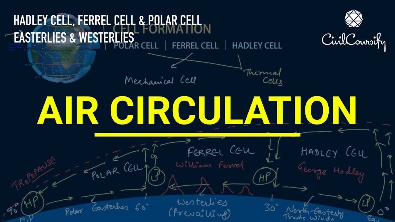
The Atmospheric circulation stands as the large-scale movement of air across our planet. Working hand in hand with ocean circulation, it functions as the primary engine by which thermal energy is redistributed over the surface of the Earth. Driven by uneven solar heating, this global system ensures that excess warmth from the tropics is channeled toward the freezing poles, maintaining the fundamental climatic balance necessary to support global life and diverse weather patterns.
The Narrative of Thermal Redistribution: Defining Atmospheric Circulation
- The Structural Logic of Latitudinal and Longitudinal Wind Belts
The global wind patterns are divided into two primary directional components: latitudinal circulation and longitudinal circulation. While latitudinal systems organize air movements into north-south repeating cells, longitudinal systems (such as the Walker Circulation) are driven by the specific placement of continents and oceans. This narrative of coordinated air masses explains why certain latitudes host lush rainforests while others contain expansive deserts.
Analyze the Mechanics of Latitudinal and Longitudinal Belts
The division between latitudinal cells and longitudinal cells arises from different physical processes. Latitudinal circulation is a direct consequence of the highest solar radiation per unit area falling near the equator. This intense solar intensity systematically decreases as latitude increases, dropping near zero at the poles. Conversely, longitudinal circulation is driven by the heat capacity of water, its absorptivity, and its mixing characteristics. Because water absorbs substantial heat without experiencing rapid temperature spikes, landmasses face much larger temperature variations than adjacent oceans, generating East-West air flows.
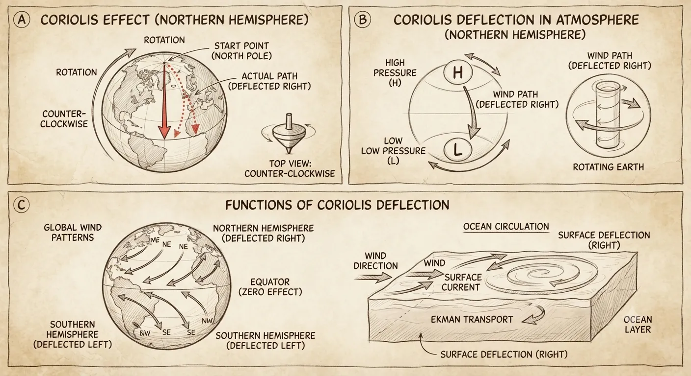
Functions of Coriolis Deflection Explore the Mechanics of the Hadley Cell
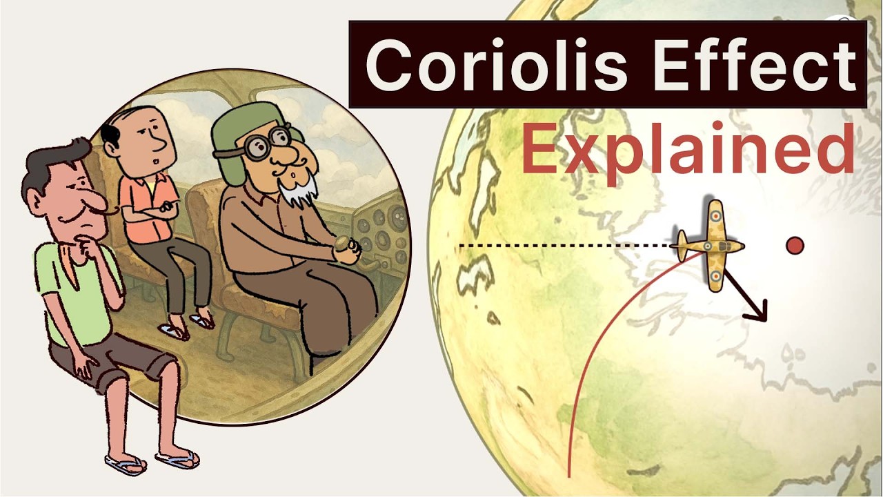
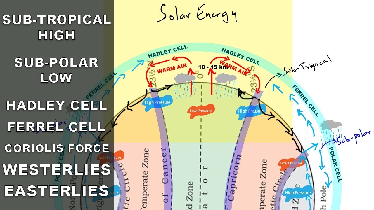
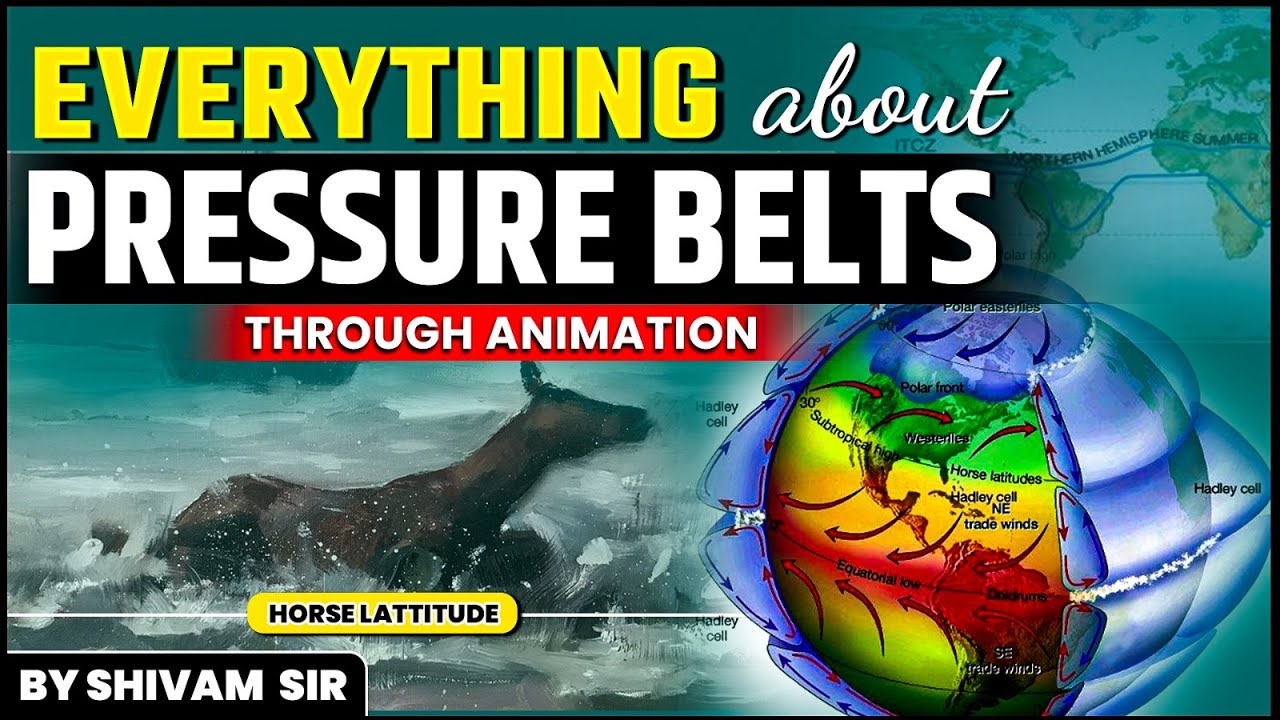
The Hadley Cell operates as the primary driver of low-latitude atmospheric dynamics. Intense solar heating at the equator forces air to warm and rise rapidly via convection, pushing it outward toward the north and south at the tropopause (the boundary separating the troposphere and stratosphere). As this air travels to approximately 30 degrees latitude, the Coriolis force deflects its path until it flows almost due east. Here, it collides with descending air from the mid-latitudes, causing both air streams to sink toward the surface. This descending air warms and dries, before returning to the equator as the steady surface winds famously known as the Trade Winds.
- (i) Equatorial heating generates strong convective updrafts that lift warm, moist air.
- (ii) Descending air currents at 30 degrees latitude create high-pressure zones characterized by dry, stable weather.
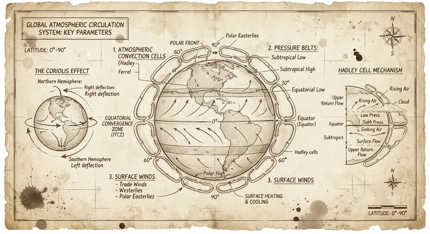
Atmospheric Circulation Framework Deep Dive into Mid-Latitudes and the Ferrel Cell
Positioned in the mid-latitudes, the Ferrel Cell functions as a weaker, intermediate circulation zone. Convective air rising near 60 degrees latitude reaches the tropopause and travels southward, deflecting west due to the Coriolis force until it meets the northward-moving air of the Hadley Cell. These colliding currents sink near 30 degrees latitude, marking the high-pressure, arid region known as the Horse Latitudes, home to famous dry deserts like the Sahara and the Mojave/Sonora. On the surface, the air returning toward high latitudes is deflected eastward, forming the warm, heat-carrying winds called the Westerlies.
- (i) The primary global circulation is driven by the hot equator (Hadley) and cold poles (Polar), leaving the Ferrel cell as a passive intermediate zone.
- (ii) Weather systems in this zone are driven by the polar jet stream (at the Ferrel-Polar boundary) and the tropical jet stream (at the Ferrel-Hadley boundary).
- (iii) Migrating convective instabilities cause these jet streams to follow irregular, wavy paths, driving cold and warm fronts across mid-latitudes.
Chronicle of the Polar Cell and High-Latitude Deserts
The Polar Cell is the simplest of the three latitudinal cells to conceptualize. Air rising from the relatively warmer 60-degree latitude zone travels toward the poles. Upon reaching these extreme latitudes, the air becomes incredibly cold and dense, causing it to converge with other high-latitude winds and sink directly over the polar regions. This perpetual downward movement of cold, dry air creates hyper-arid, cold deserts at both the North and South poles.

Aspects of Planetary Pressure Belts
Evaluate the Walker Circulation and the ENSO Phenomenon
While latitudinal cells span North-South directions, the Walker Circulation is a critical horizontal loop in the Southern Hemisphere. It is driven by surface pressure and temperature variations across the eastern and western tropical Pacific Ocean.
Assessing Upwelling, Marine Ecosystems, and El Niño Disruptions
Under normal conditions, a robust pressure gradient from east to west drives winds from the Eastern Pacific (along the coast of Peru and Chile) toward the Western Pacific (Australia and New Guinea). This movement pushes warm surface water westward, forcing cold, nutrient-rich water from the deep ocean to rise along the South American coast—a process called upwelling. The cold water supports huge blooms of Phytoplankton, which feed marine life and sea bird populations. These birds produce nutrient-rich Guano, sustaining a world-class fishing industry. This same circulation brings heavy rain and precipitation to Australia and the Western Pacific.
Important Historical Verification: Note that previous drafts or outside summaries listing "www.lotusarise.com" are watermarks from the source material and have been omitted from the core definitions here to preserve a clean, academic narrative.
However, when the Trade Winds weaken, the warm water accumulated in the western Pacific slowly drifts backward toward South America, replacing the cool Peruvian current. This warm water anomaly off the coast of Peru is known as El Niño. It is coupled with atmospheric pressure changes across the Pacific and Australia, a joint feedback loop known as the Southern Oscillation. Together, they form the El Niño-Southern Oscillation (ENSO), which causes dramatic global weather anomalies, bringing heavy floods to the arid South American coast while triggering devastating droughts in Australia and India, alongside floods in China.
Analyze Seasonal Shifts in Global Pressure Belts
The global system of high and low pressure is not static; it migrates dynamically throughout the year following the apparent seasonal path of the sun.
July and January Thermal Deviations across Hemispheres
During the Northern Hemisphere summer in July, the sun shifts northward, pulling the thermal equator (the band of highest global temperature) north of the geographical equator. Consequently, all major global pressure belts migrate slightly north of their annual averages. In January, the winter season reverses these dynamics, pushing the pressure belts south. Because the Southern Hemisphere is dominated by vast oceans rather than landmasses, the physical shift of these belts is less pronounced there. Furthermore, land-sea thermal contrasts cause continents to develop high-pressure centers in winter (due to rapid cooling) and low-pressure centers in summer (due to rapid heating), while the oceans experience the exact opposite behavior.
Summary
Global atmospheric circulation is a beautifully balanced, interconnected machine that redistributes thermal energy through three distinct latitudinal cells (Hadley, Ferrel, and Polar) and longitudinal loops like the Walker Circulation. From driving the wet monsoons of Asia to creating the hyper-arid deserts of the Horse Latitudes and the poles, this complex movement of air shapes the biosphere. Understanding the delicate balance of this system—and how shifts like ENSO can disrupt global food chains and weather—remains essential for climatology and meteorological forecasting.
Quick Revision Points for Students
Reviewing the core empirical and physical facts ensures full retention for examinations.
- (i) The Hadley Cell is powered by equatorial solar heating, driving air upward and depositing it back down near 30 degrees latitude as dry air.
- (ii) The Ferrel Cell is a weaker, intermediate zone where westerly winds transport heat, while the Polar Cell generates cold deserts at both poles.
- (iii) The Walker Circulation is an East-West ocean-air loop over the Pacific; its collapse initiates the destructive warm-water El Niño (ENSO) phase.
- (iv) Pressure belts shift north in July and south in January, showing less movement in the Southern Hemisphere due to the moderating effect of ocean water.
Frequently Asked Questions (FAQ)
Q1: Why are major deserts located around 30 degrees latitude in both hemispheres?
A1: At 30 degrees latitude (the Horse Latitudes), dry air descending from the convergence of the Hadley and Ferrel cells warms and compresses, inhibiting cloud formation and producing arid climates.Q2: How does Walker Circulation benefit marine life and fisheries in South America?
A2: Strong trade winds push warm water west, causing cold, nutrient-dense deep water to rise (upwelling) along the Peruvian coast. This supports abundant Phytoplankton, feeding seabirds that produce Guano, and supporting a highly productive fishing industry.Q3: Why are seasonal pressure belt shifts less noticeable in the Southern Hemisphere?
A3: The Southern Hemisphere is dominated primarily by water, which has a high heat capacity. This prevents the extreme temperature changes seen on large landmasses, leading to much smaller seasonal pressure shifts.