In this guide, we explore how rocks are arranged inside the Earth's crust across India. Starting from ancient history back in , scientists have developed special timelines to track how our planet changed over time. Understanding key scientific terms like geological structure helps us learn how mountains rise, how plains form, and how land stays stable over millions of years.
🎯 In this chapter, you will understand:
- How rocks are stacked and arranged inside the Earth's outer crust.
- What the Geological Time Scale is and who helped create it.
- The major land divisions: Peninsular India and Extra Peninsular India.
- The three giant historical events that shaped India's rocks and rivers.
💡 Why this topic matters: The rocks under our feet tell the story of Earth's past, including how mountains like the Himalayas formed and why rivers build rich soil for farming.
🧠 Core Idea: Deep movements inside the Earth stack rock layers into distinct shapes and features, dividing India into unique geographical regions built over massive spans of time.
Geological Structure of India
When we talk about the geological structure of India, we are looking closely at how giant rocks are arranged, folded, and stacked inside the Earth's outer crust. Imagine building blocks piled on top of one another over millions of years! This whole process happens because of big, powerful movements deep inside the Earth. Sometimes, these deep Earth forces push and squeeze the land, while at other times, the Earth stays very still and quiet for long stretches of time. Learning about geological structure also tells us about special rock shapes and unique formations, such as the famous Gondwana structure which holds rich mineral layers.
Rock System Arrangements
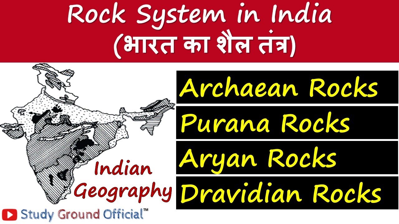
To help us visualize how all these different rocks fit together across the country, scientists use maps and visual diagrams showing the rock systems of India.
- (i) Rocks stack in deep layers created by crustal forces.
- (ii) Peaceful periods allow rocks to settle smoothly without shifting.
Gondwana Rock Features
The Gondwana rock arrangement is a unique type of rock structure found in India that carries important clues about ancient land movements.
- (a) Formed during periods when land shifted slowly.
- (b) Contains distinctive layers of ancient sediment.
- (c) Displays special rock shapes and features.
- (d) Helps explain the arrangement of minerals deep underground.
Geological Time Scale
Scientists rely on a clever calendar called the Geological Time Scale to organize rock layers and ancient life in order by time. Just like a history textbook uses dates to track events, this special scale helps us figure out exactly when different rocks and living creatures first appeared on Earth, how they grew and changed over long periods, and when they finally disappeared or went extinct.

- The Geological Time Scale acts like a master timeline for planet Earth.
History of Geological Time Scale
The journey to create a standard worldwide timeline took work from dedicated scientists across different centuries.
- (i) A scientist named Giovanni Ardunia created the very first version of the Geological Time Scale way back in the year .
- (ii) Later, in , an official standard version was formally established in Italy during the International Geological Congress.
- (iii) For India specifically, a scientist named T.S. Holland introduced the Indian Geological Time Scale to fit the country's unique rock history.
- (iv) This specialized timeline helps geologists match Indian rock layers with global geological eras.
Rock History and Major Sections of India
To clearly understand India's rich rock history, geologists look at where different places are located today and what happened to them long ago. The entire country is mainly divided into two big geographic sections: Peninsular India (the stable southern landmass) and Extra Peninsular India (the northern region that includes mountain ranges).
- These regions show how different parts of India formed at completely different times.
Three Major Geological Events of India
India's long geological story was shaped by three major historical events that built its physical features.

Geographical Map of India displaying Peninsular and Extra Peninsular regions. - Ancient Landmass Stability: Peninsular India has remained a solid, stable part of an ancient landmass ever since the Earth's crust first formed billions of years ago.
- Rise of the Himalayas: The mighty Himalayan mountains rose up high into the sky during a dynamic geological era called the tertiary period.
- Formation of the Northern Plains: The wide, flat Indo-Gangetic plain was formed during the Pleistocene period.
- Ongoing Sedimentation Process: Rivers are still actively adding dirt, mud, and sand to this plain today through a natural process called sedimentation in their wide floodplains.
⚡ Quick Revision Capsule: Geological Structure of India
Use this quick guide to review the core concepts, historical timelines, and major regional divisions of India's rock systems.
| Feature / Concept | Key Details & Scientific Terms | Historical Timeframe / Location |
|---|---|---|
| Geological Structure | Arrangement of rocks inside Earth's crust; includes unique setups like the Gondwana structure. | Formed via crustal movements and calm periods. |
| First Geological Time Scale | Created by scientist Giovanni Ardunia to put rock layers and fossil life in chronological order. | |
| Standard International Scale | Formally standardized during the official meeting of the International Geological Congress. | (Italy) |
| Indian Geological Time Scale | Introduced by scientist T.S. Holland specifically for India's rock systems. | Customized for the Indian Subcontinent. |
| Three Major Geological Events |
1. Peninsular crust stabilization. 2. Rise of the Himalayas during the tertiary period. 3. Plain formation in the Pleistocene period via sedimentation. |
1. Earth's crust origin. 2. Tertiary period. 3. Pleistocene period to present day. |
📝 Summary
The geological structure of India explains how rock layers were formed and organized deep inside the Earth's outer crust. Using the Geological Time Scale—first developed in and standardized globally in —geologists trace the evolution of Earth's crust. India is split into Peninsular and Extra Peninsular regions. Its land was shaped by three big milestones: the formation of an ancient stable crust in Peninsular India, the rising of the Himalayas during the tertiary period, and the building of the flat Indo-Gangetic plain during the Pleistocene period through continuous river sedimentation.
🚀 Quick Revision Points
Essential facts to review before examinations:
- (i) Geological structure refers to how rock layers are stacked and arranged underground.
- (ii) Giovanni Ardunia initiated the Geological Time Scale in ; T.S. Holland created the Indian standard.
- (iii) Peninsular India is one of the oldest and most stable rock blocks on Earth.
- (iv) Himalayas rose in the tertiary period, while plains formed in the Pleistocene period through sedimentation.
- 💡 Exam Tip: Remember the two key geological periods: the tertiary period is linked to the rise of the Himalayas, while the Pleistocene period is linked to the formation of the Indo-Gangetic plain!
❓ Frequently Asked Questions (FAQ)
Q1: What is geological structure?
A1: It is the way rocks are stacked, folded, and arranged inside the Earth's outer crust due to deep Earth movements or long periods of calm.Q2: Who created the Indian Geological Time Scale?
A2: Scientist T.S. Holland introduced the Indian Geological Time Scale to categorize India's specific rock history.Q3: How was the Indo-Gangetic plain formed?
A3: It formed during the Pleistocene period through sedimentation, where rivers continuously deposit sand, dirt, and silt onto their floodplains.