The Brahmaputra Plains, also recognized as the Assam Valley or Assam Plain, constitutes a highly dynamic physical and hydrological corridor. Extending strategically across northeastern India, this alluvial basin is carved by the Brahmaputra River System, which ranks among the largest rivers globally by volume. Understanding its structural dimensions, varying channel slopes, specific tributary actions, and monsoon-driven discharge patterns is critical for analyzing the socio-economic and environmental landscape of this vital geographic division.
Geographic Profile of the Brahmaputra Plains (Assam Valley)
- The Narrative Genesis of the Eastern Riverine Tract
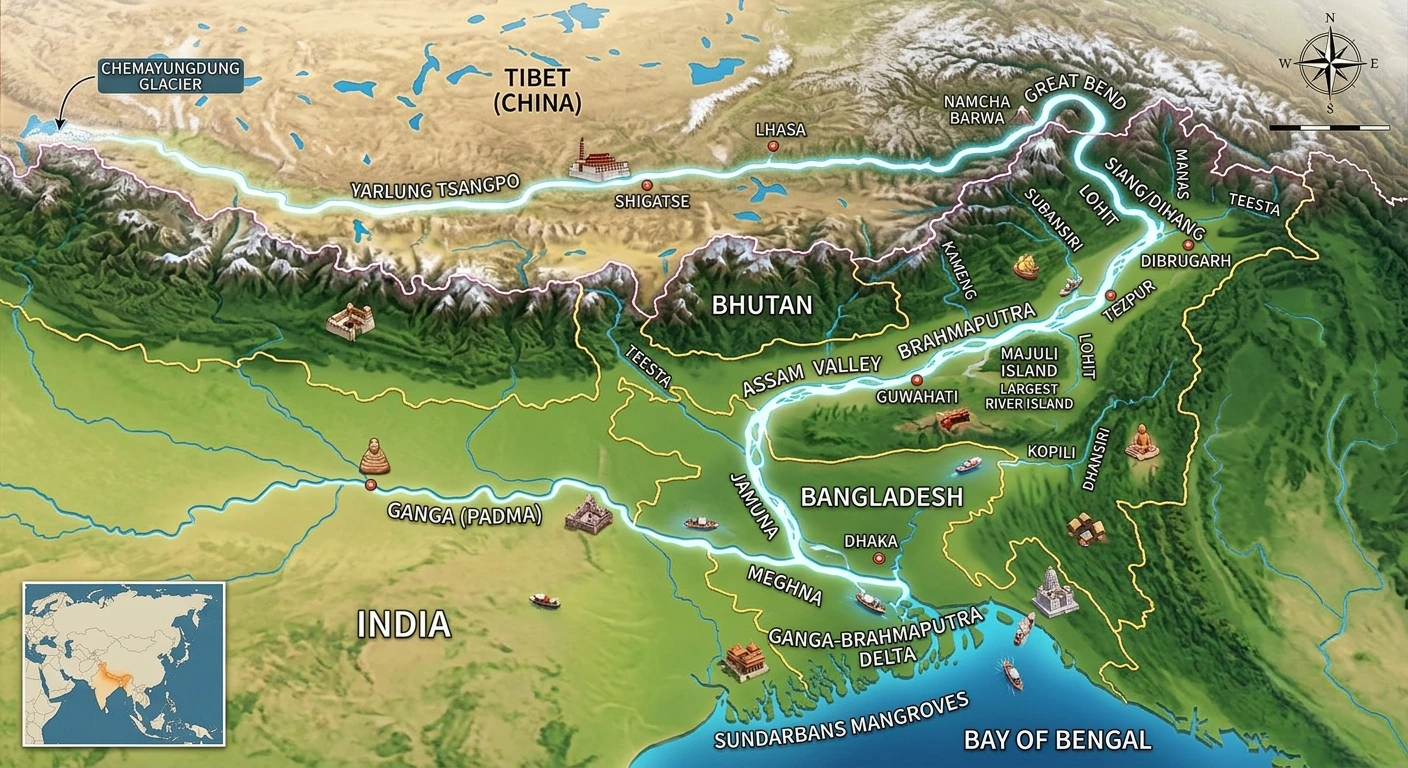
The layout of the Brahmaputra Plains unfolds across a specific spatial corridor, stretching deliberately from the Assam-Arunachal Border down to the Assam-Bangladesh Border. The terrain presents a distinct gradient, sloping systematically from East to West. Geographically, this vast plain extends precisely from Sadiya in Assam to Dhubri near Bangladesh, establishing a continuous structural path that defines the physiography of the entire Northeastern zone. The region stands out as the most fertile tract in the North Eastern region, celebrated for its unique features such as numerous tributaries, meandering river patterns, oxbow lakes, marshy lands, and large riverine islands. A prime example of ecological stewardship within this tract is Jadav Payeng, widely celebrated as the Forestman of this region. He has independently grown 550 hectares of forest in this specific ecosystem, an outstanding environmental contribution for which he has been officially awarded the prestigious Padma Shri.
Features of Brahmaputra Valley and Drainage Area Distribution
The Brahmaputra Valley maintains an average width of about 80 Km. The primary river traversing this valley, the Brahmaputra, is one of the grandest watercourses on Earth, ranking fifth globally with respect to its average discharge. Originating from the Kailash ranges of the Himalayas at an impressive elevation of 5,300 M, the river charts a long transnational course. After flowing extensively through Tibet, it enters India through Arunachal Pradesh, passes through the plains of Assam, and flows into Bangladesh before reaching its ultimate destination at the Bay of Bengal.
Explore the Catchment Data and State-Wise Drainage Area
The geographical footprint of the basin covers a vast multi-national area. The total catchment expanse of the Brahmaputra is divided as follows: 2,93,000 Sq. Km lies in Tibet; 2,40,000 Sq. Km is shared between India and Bhutan; and 47,000 Sq. Km sits within Bangladesh. Up to its final confluence inside Bangladesh, the entire basin extends over an area of 5,80,000 Sq. Km. The drainage area situated specifically inside India measures 1,94,413 Sq. Km, which represents nearly 5.9% of the total geographical area of the country. This Indian sub-basin is bounded on the north by the Himalayas, on the east by the Patkai range of hills running along the Assam-Burma border, on the south by the Assam range of hills, and on the west by the Himalayas and the ridge separating it from the Ganga sub-basin. The distribution of this drainage area across the Indian States is presented below:
State Drainage area (sq.km) Arunachal Pradesh 81,424 Assam 70,634 West Bengal 12,585 Meghalaya 11,667 Nagaland 10,803 Sikkim 7,300 Total 194,413 The most predominant soil types found within this sub-basin are red loamy soil and alluvial soil, alongside variations of sandy, loamy, clayey soils, their combinations, and laterite soils. The total culturable area of this sub-basin is estimated at roughly 12.15 M. ha, accounting for 6.2% of the total culturable area of the country.
Hydrology and Braiding Dynamics of the Main River Course
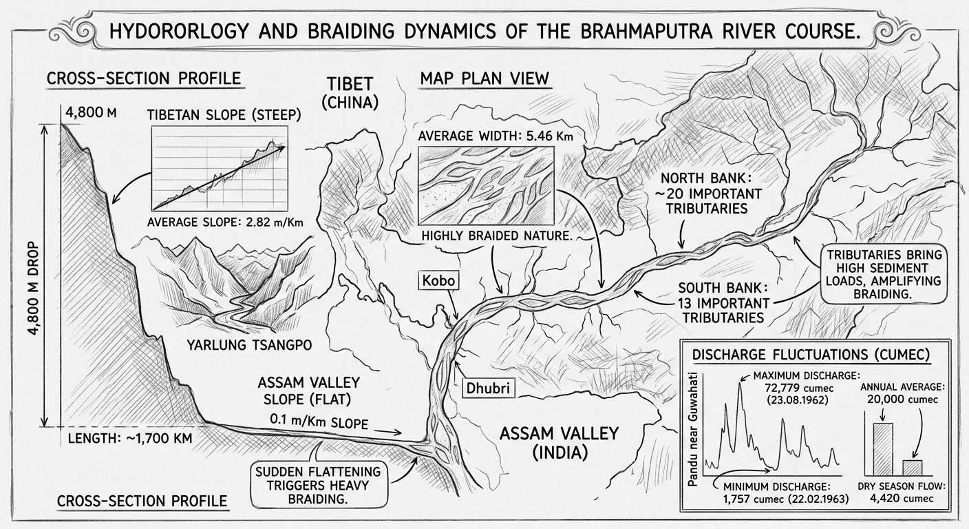
The main channel of the Brahmaputra exhibits an average width of 5.46 Km. Its discharge levels fluctuate heavily between seasons. The absolute maximum discharge at Pandu near Guwahati was recorded as 72,779 cumec on the date of 23.08.1962, whereas the minimum discharge dropped to 1,757 cumec on 22.02.1963. On a broader scale, its average annual discharge hovers around 20,000 cumec, while the average dry season flow reduces to 4,420 cumec.
Analyze the Discharge Figures and Slopes from Tibet to Assam
The dramatic change in elevation transforms the physical behavior of the river as it moves into India. The river slope remains exceptionally steep until it reaches the Indian borders, dropping about 4,800 M over a length of approximately 1,700 Km within China (Tibet), yielding an average slope of about 2.82 m/Km. However, this slope is sharply reduced to a mere 0.1 m/Km once it enters the Assam valley. This sudden flattening of the river slope forces the river to become highly braided in nature within the Assam valley. As it flows through the valley from Kobo to Dhubri, the main channel is joined by approximately 20 important tributaries on its North bank and 13 important tributaries on its South bank. The combination of these streams bringing in high sediment loads actively triggers and amplifies the heavy braiding process.
Characteristics of North and South Bank Tributaries and Flood Problems
All the tributaries sustaining the valley are entirely rain-fed and swell drastically during periods of heavy precipitation. This moisture is primarily driven by the South West monsoon, with heavy rainfall concentrated from May to September. Every tributary experiences multiple flood waves depending on the rainfall within its specific catchment. If the peak floods of individual tributaries coincide directly with the main flood crest of the Brahmaputra, it causes severe problems and massive devastation across the plains.
Distinguishing North Bank vs South Bank Tributaries
The behavioral patterns of the northern and southern bank tributaries vary significantly based on their terrain of origin:
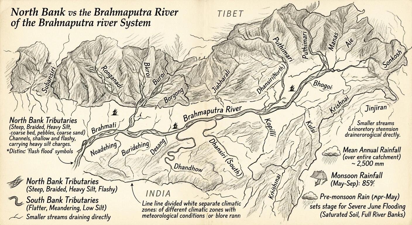
- (i) The North Bank Tributaries possess very steep slopes and shallow braided channels for considerable distances from the foothills, sometimes extending all the way to their outfall. They flow over beds composed of boulders, pebbles, and coarse sand, carrying an exceptionally heavy silt charge and demonstrating flashy, sudden floods. Key examples include the Subansiri, Ronganadi, Dikrong, Buroi, Borgong, Jiabharali, Dhansiri (North), Puthimari, Manas, Beki, Aie, and Sonkosh.
- (ii) The South Bank Tributaries display comparatively flatter grades and deep meandering channels nearly from the foothills onward, carrying a low silt charge in comparison. Key examples include the Noadehing, Buridehing, Desang, Dikhow, Bhogdoi, Dhansiri (South), Kopilli, Kulsi, Krishnai, Dhdhnoi, and Jinjiran.
In addition to these major systems, multiple smaller streams drain directly into the main river channel. The meteorological conditions between the catchments in Tibet and India differ significantly as they sit in separate climatic zones. The mean annual rainfall calculated over the entire catchment (including Tibet and Bhutan) is roughly 2,500 mm, with 85% of it occurring during the monsoon months from May to September. Additionally, the valley receives substantial rainfall during April and May due to pre-monsoon thunderstorm activities, which sets the stage for severe flooding during heavy rains in June when the soil is already fully saturated and the river banks are at full stage.
Summary
The Brahmaputra River Basin and Plains form a unique geographical tract. This region transitions from steep Himalayan drops into a highly flat, braided 80 Km wide valley. Fed by a high volume of monsoon rainfall (amounting to an annual mean of 2,500 mm), its networks of steep, silt-heavy North bank tributaries and flatter, meandering South bank tributaries define the region's physical geography, creating a highly fertile alluvial system that remains prone to severe, interconnected flood cycles.
Quick Revision Points for Students
Reviewing the core empirical and geographical facts ensures full retention for examinations.
- (i) The valley spans an average width of 80 Km, sloping gently from East to West between Sadiya and Dhubri.
- (ii) The total basin area is 5,80,000 Sq. Km, with India containing 1,94,413 Sq. Km (roughly 5.9% of the country's geographical area).
- (iii) The river slope drops from 2.82 m/Km in Tibet to just 0.1 m/Km in the Assam valley, causing its characteristically braided channel nature.
- (iv) Monsoon rainfall accounts for 85% of the annual precipitation, leading to severe flood waves when tributary discharges coincide with the main river.
Frequently Asked Questions (FAQ)
Q1: Why does the Brahmaputra River become braided in the Assam Valley?
A1: The river slope drops drastically from an average of 2.82 m/Km in Tibet to 0.1 m/Km in the Assam valley. This sudden flattening, combined with high sediment loads brought by 20 North bank and 13 South bank tributaries, activates its braided nature.Q2: What are the main differences between the North bank and South bank tributaries?
A2: North bank tributaries feature steep slopes, shallow braided channels, boulder/pebble beds, heavy silt charges, and flashy floods. South bank tributaries have flatter grades, deep meandering channels, and lower silt loads.Q3: What historical discharge extremes have been recorded for the Brahmaputra River?
A3: A maximum peak discharge of 72,779 cumec was recorded at Pandu near Guwahati on 23.08.1962, while a minimum discharge of 1,757 cumec was observed on 22.02.1963.
Important links for this article includes Water Resources page of Assam Government. Click here to visit page