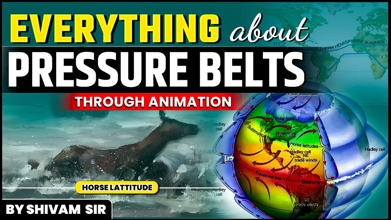
The study of Atmospheric Pressure and Global Wind Systems is very important for students learning geography and climate. It explains how air weight and air movement work together. Heat from the Sun, height above sea level, and the spin of the Earth create zones of high and low air pressure. These zones drive the general circulation of the atmosphere, which acts as Earth's natural air conditioner by spreading heat across the planet. Understanding tools like barometers, the bending power of the Coriolis force, and major global pressure belts is the secret to mastering weather and climate dynamics.
🎯 In this chapter, you will understand:
- What atmospheric pressure is and how we measure it using barometers.
- How heat, height, and Earth's spin create high and low pressure zones.
- The main forces that push and push back on winds, like the Coriolis effect.
- How global wind belts and climate patterns like El Niño affect weather everywhere.
💡 Why this topic matters: Air pressure differences create wind. Without these air movements, parts of our planet would be too hot or too cold for life to exist.
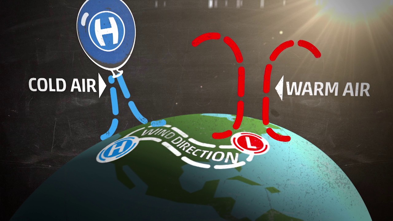
🧠 Core Idea: Heavy cold air pushes down to build high pressure, while warm light air rises up to leave low pressure. Air always travels from high pressure to low pressure, making wind!
Atmospheric Pressure, Forces, and Global Wind Circulation Dynamics: An Essential Geographical Study
Air might feel weightless when you run through it, but the vast sky above us actually pushes down on Earth with a huge amount of weight. This force is called atmospheric pressure. It is measured as force over a set space. In weather studies, scientists measure this force in units called millibars (mb). One millibar equals roughly the weight push of one gram over one square centimeter. To keep track of this changing force, weather scientists use measuring instruments called barometers.

- (i) The weight pushed down by air at any spot is known as air pressure, measured mostly in millibars.
- (ii) Scientists use tools such as the Mercury Barometer and Aneroid Barometer to check pressure. Normal air pressure at sea level averages about .

Mercury and aneroid barometer, tools used for measuring atmospheric pressure. - (iii) Small changes in air pressure, usually caused by temperature changes, start air moving and create winds.
Influencing Factors and Distribution of Atmospheric Pressure Across Earth
Areas of high pressure (H) and low pressure (L) act like engines for daily weather. They are made by a mix of heat forces and mechanical movements that shift air up, down, and across the globe.
Thermal and Dynamic Drivers of Atmospheric Pressure Systems
Heat is the main starter for pressure shifts. When air gets super warm, it expands like a party balloon and gets lighter. This light air rises and leaves behind a zone of low pressure. But when air gets very cold, it shrinks, gets heavy, and sinks down to create a zone of high pressure. We can easily see this happen in real life: hot places near the Equator have warm low-pressure zones, while icy polar regions have heavy high-pressure zones.
- (i) Thermal Factors: Heating makes air expand and become lighter (low pressure). Cooling makes air contract and become heavy (high pressure).
- (ii) Dynamic Factors: Physical movements like the pressure gradient (how fast pressure changes between two spots) and the spinning effect of Earth, called the Coriolis force, shape worldwide pressure belts.
Understanding the Pressure Gradient and the Role of Isobars
The pressure gradient is like an invisible hill that decides how fast wind will blow. It measures how quickly air pressure changes over a flat distance. On weather maps, lines called isobars connect points that have the exact same air pressure reading. Reading these lines helps us predict how strong winds will be.

Definition of pressure gradient in meteorology, showing how pressure differences affect wind flow. - (a) Steep Gradient: Isobars that are squeezed closely together mean a steep slope and strong, fast winds.
- (b) Gentle Gradient: Isobars spaced far apart mean a gentle slope and soft, slow winds.

Pressure gradient on isobars, demonstrating the change in pressure across regions.
Vertical and Horizontal Distribution of Pressure in the Atmosphere
Air pressure is not identical everywhere. It changes quickly as you climb higher or travel across regions. Going up into the sky, pressure drops fast because there is less air resting above your head. Air near the ground is squished tight and weighs more, while upper atmospheric layers are thin. Across the ground, pressure shifts because Sun warmth hits different locations unevenly.
- (i) Vertical Distribution: Pressure always goes down as you climb higher, though changes in temperature, water moisture, and gravity alter the exact rate. A rising barometer reading usually promises clear and stable weather, while a falling reading points to stormy skies and clouds.

Vertical distribution of pressure in the atmosphere, depicting the variation of pressure at different altitudes. 
Non-linear vertical distribution of pressure, showing complex variations in atmospheric pressure. - (ii) Horizontal Distribution: Side-to-side pressure shifts happen across Earth due to three key factors:

Horizontal distribution of pressure, illustrating how pressure varies across the Earth's surface. - Air Temperature: Strong sunshine creates low pressure near the Equator as hot air rises, while freezing poles create heavy high pressure as cold air sinks.
- Earth's Rotation: The spinning globe dynamically creates subpolar low-pressure belts and subtropical high-pressure belts by curving moving air.
- Water Vapor: Damp air full of moisture is actually lighter than dry air, so humid air creates lower pressure.
- (i) Vertical Distribution: Pressure always goes down as you climb higher, though changes in temperature, water moisture, and gravity alter the exact rate. A rising barometer reading usually promises clear and stable weather, while a falling reading points to stormy skies and clouds.
Forces Influencing Wind Movement: The Pressure Gradient and Coriolis Effect
Wind is just air traveling from one place to another. How fast it blows and which direction it turns depends on four basic forces pushing and pulling on it all at once.

The Pressure Gradient Force: The Engine of Wind Speed
This is the main force that starts air moving in the first place. It pushes air straight across isobar lines, driving it out from high-pressure spots toward low-pressure spots. The bigger the pressure difference, the stronger this push gets.
The Coriolis Force: The Deflector of Wind Direction
Because planet Earth spins on its axis, moving objects like air currents get bent sideways instead of moving in a straight line. This curving power is called the Coriolis force.

Direction of the Coriolis force, showing how the force influences movement in different hemispheres. - (i) Northern Hemisphere (NH): Moving winds turn toward their right.
- (ii) Southern Hemisphere (SH): Moving winds turn toward their left.
- (iii) This deflection force is strongest at the North and South Poles, but drops to zero right at the Equator. This is why major storms like tropical cyclones rarely form directly along the Equator.
- (iv) This bending motion helps make high-altitude geostrophic winds that flow parallel to isobar lines. It also shapes circular storms called cyclonic circulation (air spinning into low pressure) and anticyclonic circulation (air spinning out from high pressure).

Illustration of the Coriolis force on ocean currents and atmospheric streams, showing its effect on motion. 
Effect of the Coriolis force on winds, demonstrating how Earth's rotation affects wind direction.
Frictional and Gravitational Forces Modifying Air Flow
While pressure push and Coriolis bending guide upper atmospheric winds, surface friction slows air down, and gravity anchors air to Earth.
- (a) Frictional Force: Rough land surfaces drag against air to slow it down. This friction is strongest in the lower atmosphere up to about high. Over smooth sea oceans, friction is tiny so winds blow faster.
- (b) Gravitational Force: Earth's gravitational pull tugs air downward toward the ground, holding our whole atmospheric blanket in place.
Global Pressure Belts and Atmospheric Circulation Cells: The Framework of Climate
Earth's atmosphere acts like a massive heat loop divided into seven broad global pressure belts that send air circulating around the world.

The Four Major Global Pressure Zones
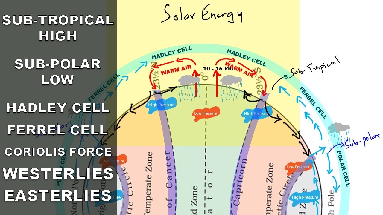
Across the globe, air rises and sinks in four primary pressure patterns.

Low and high-pressure areas, showing the zones of atmospheric pressure variations. - (i) Equatorial Low Pressure Belt (0°–5° N/S): Soaked in strong sunshine, hot air rises up continuously to build a low-pressure ring. Sailors call this gentle, quiet region the doldrums.
- (ii) Sub-tropical High Pressure Belts (around 30° N/S): Here, cooled air sinks down from upper sky loops to build high-pressure belts. Called the Horse Latitudes, winds spread outward from here as Trade Winds toward the Equator and Westerlies toward the poles.
- (iii) Sub-polar Low Pressure Belts (60°–70° N/S): Warm middle-latitude air collides with icy polar air here, forcing air upward to form low-pressure stormy ocean belts.
- (iv) Polar High Pressure Belts (70°–90° N/S): Super cold air rests over icy polar caps, creating heavy, sinking high-pressure caps.
The Hadley, Ferrel, and Polar Circulation Cells
Three giant air loops called circulation cells sit in each hemisphere to carry warm air away from the tropics and bring cool air back.
- (a) Hadley Cell (Tropics): Warm air rises at the Equator, travels high overhead toward the poles, cools off, and sinks down around 30° latitude. The returning surface airflow is known as the Trade Winds.
- (b) Ferrel Cell (Mid-latitudes): Situated between 30° and 60° latitude, this middle loop is driven by the neighboring air cells. Its surface winds are the regular Westerlies.
- (c) Polar Cell (Poles): Freezing air drops down at the poles and streams along the ground as Polar Easterlies, rising again when it reaches the subpolar low zones.
Seasonal, Local Winds, Air Masses, and Weather Systems
Smaller weather patterns operate alongside these global circulation loops:
- Seasonal Winds: The regular Monsoon brings dramatic seasonal wind reversals across South Asia when land temperatures shift between summer and winter.
- Local Winds: These include short-distance airflow like coastal land breezes and sea breezes, as well as slope winds like daytime valley breezes and nighttime mountain winds.
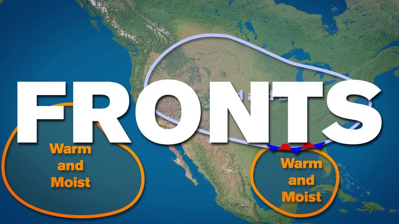
- Air Masses and Fronts: Huge bodies of air with uniform temperature and dampness are called air masses. When two different air masses bump into each other, their meeting boundary is called a front.
- Cyclones and Storms: Low-pressure circular storms include warm ocean tropical cyclones and larger mid-latitude cyclones, along with short, sharp storms like thunderstorms and destructive tornadoes.
The Walker Circulation, ENSO, and Global Climate Teleconnections
Across the tropical Pacific Ocean, an east-to-west air circulation loop called the Walker circulation shapes ocean climate. When this loop shifts out of its normal rhythm, it triggers a major climate pattern known as the El Niño Southern Oscillation (ENSO).
- (i) Normal Walker Circulation: Warm air rises near Australia to bring rain, while cool air sinks along South America. This brings up deep, cold ocean water full of marine nutrients along South American shores.
- (ii) El Niño Events: When trade winds weaken, warm ocean water slides east toward South America. This disrupts nutrient currents, bringing unusually heavy rains to South America and severe dry droughts to Australia and India.
⚡ Quick Revision Capsule: Global Pressure and Wind Systems
Here is a simple summary breakdown of Earth's key pressure zones and air circulation patterns:
| Pressure Zone | Latitude Location | Key Characteristics & Winds |
|---|---|---|
| Equatorial Low | 0° – 5° N/S | Hot rising air, quiet calm winds called doldrums. |
| Subtropical High | 30° N/S | Sinking heavy air, known as Horse Latitudes; feeds Trade Winds. |
| Subpolar Low | 60° – 70° N/S | Meeting ground of warm and cold air; heavy stormy weather. |
| Polar High | 70° – 90° N/S | Icy cold sinking air; sends out dry Polar Easterlies. |
| ENSO / El Niño | Tropical Pacific | Shifting trade winds that cause droughts in India and heavy rain in South America. |
📝 Summary
Understanding atmospheric pressure and global wind patterns gives us the key to explaining daily weather and climate. From checking pressure readings with barometers to watching how the Earth's rotation curves winds via the Coriolis force, we can see how heat spreads around our planet. The three giant wind loops—the Hadley Cell, Ferrel Cell, and Polar Cell—work continuously to carry heat from hot tropical oceans to frozen poles. Recognizing these pressure patterns helps students understand storms, monsoon rains, and global weather events like ENSO during competitive geography examinations.
🚀 Quick Revision Points
Essential facts to review before examinations:
- (i) Atmospheric pressure averages at sea level and is measured with a barometer.
- (ii) Warm air rises to leave low pressure, while cold heavy air sinks to build high pressure.
- (iii) The Coriolis force turns wind right in the Northern Hemisphere and left in the Southern Hemisphere.
- (iv) Global wind loops include the tropical Hadley Cell, mid-latitude Ferrel Cell, and cold Polar Cell.
- 💡 Exam Tip: Remember that Coriolis deflection is zero at the Equator and strongest at the Poles. Isobars drawn close together on a map always signal fast, strong winds!
❓ Frequently Asked Questions (FAQ)
Q1: What is atmospheric pressure?
A1: Atmospheric pressure is the weight push of the air column pressing down on Earth's surface.Q2: How does the Coriolis force affect wind direction?
A2: It bends moving air to the right in the Northern Hemisphere and to the left in the Southern Hemisphere due to Earth's spin.Q3: What happens during an El Niño event?
A3: Trade winds weaken across the Pacific Ocean, shifting warm water east. This causes flooding rains in South America and severe dry droughts in regions like India and Australia.