Embark on a geographical journey exploring the dynamic processes of Precipitation, Evaporation, and Condensation, which collectively drive the Earth's vital water cycle. This intricate atmospheric mechanism, varying in intensity and form across the globe, is crucial for understanding weather phenomena and climate patterns. For students preparing for geography and environmental science examinations, mastering the concepts of humidity, cloud formation, and the three main types of rainfall (Convectional, Orographic, and Cyclonic) is indispensable for achieving top marks in physical geography fundamentals.
🎯 In this chapter, you will understand:
- How water constantly moves between the ground and sky in the water cycle.
- The difference between absolute and relative humidity, and what dew point means.
- How dew, frost, fog, smog, and different cloud types form in our atmosphere.
- Why it rains, how rain is categorized into three types, and how rainfall is spread across the world.
💡 Why this topic matters: Water keeps every living thing on Earth alive. Knowing how water turns into invisible gas, forms clouds, and falls back down as rain helps us understand daily weather, farming, and changing climate patterns.
🧠 Core Idea: Heat from the Sun turns water into gas, which rises, cools down into cloud droplets, and returns to Earth as rain, snow, or hail in an endless cycle.
Understanding the Water Cycle: Evaporation, Condensation, and Precipitation in the Atmosphere
The atmosphere acts as a giant moving storage room for moisture. It constantly shifts water between large oceans, the land, and the air above us. Even though invisible water vapour makes up only zero to four percent of the total air by volume, it works like a powerful engine that drives almost all weather phenomena.

- (i) Water stays in the air in three different forms: gaseous (water vapour), liquid (rain drops and cloud droplets), and solid (snowflakes and ice crystals).
- (ii) Moisture gets into the air mainly from big lakes and oceans through evaporation, and from plant leaves through a process called transpiration.
- (iii) The endless water cycle repeats four simple steps: evaporation, transpiration, condensation, and precipitation. This keeps water moving around our planet forever.

Exploring Humidity: Absolute, Relative, and the Dew Point Concept
Humidity is simply the measure of how much water vapour is hidden in the air. It tells weather experts whether the air feels dry or sticky, and if rain is likely to fall on your neighborhood.
Absolute Humidity: Measurement of Actual Water Content
Absolute humidity measures the true, real weight of water vapour inside a specific box of air. We usually weigh it in grams per cubic meter (g/m3). It tells us the exact amount of water present regardless of how hot or cold the air is. However, warm air has the ability to hold much more water vapour than cold air.

Absolute Humidity: Conceptual diagram showing the amount of water vapor in the air and its measurement as absolute humidity. - (i) It is defined as the weight of water vapour in a certain volume of air.
- (ii) This number changes only if we add or remove actual moisture from that air.
Relative Humidity, Saturation, and the Critical Dew Point
Relative humidity (RH) is a percentage that compares how much moisture is currently in the air to the maximum amount the air could possibly hold at its current temperature. High relative humidity means the air is almost full or near its saturation point, so clouds and rain can easily form. RH is usually higher over oceans because water is constantly evaporating, and lowest over dry continents and deserts. When air becomes completely full of moisture, we say it is saturated, and the exact temperature where this happens is called the dew point.

Relative Humidity: Explanation of relative humidity, its relationship with air temperature, and its role in weather conditions. - (a) Formula: (Actual Humidity ÷ Saturated Humidity) × 100.
- (b) The dew point is the exact temperature where cooling air becomes 100% full of moisture and starts making water drops.
Evaporation and Condensation: The Dual Processes of Phase Change
Evaporation and condensation are two opposite team players that shift water between Earth's surface and the sky using heat energy.
Evaporation: The Liquid-to-Gas Transformation Driven by Heat
Evaporation happens when liquid water absorbs energy and turns into invisible water vapour gas. The special heat energy needed to change liquid to gas without changing its temperature is called the latent heat of vapourization. High temperatures make water evaporate faster because warm air can swallow more vapour. Blowing wind also speeds up evaporation by blowing away moist air and bringing in dry air over the water surface.

Changing States of Water: Diagram showing transitions between solid, liquid, and gaseous states through processes like melting, evaporation, and condensation. - (i) Turning liquid into gas requires absorbing heat energy from the surrounding environment.
- (ii) Warm weather, dry air, and strong winds make water dry up and evaporate very quickly.
Condensation: The Gas-to-Liquid Reversion and Hygroscopic Nuclei
Condensation is the exact opposite process where water vapour cools down and turns back into liquid drops. If air cools down extremely fast below freezing (), vapour turns straight into solid ice crystals through sublimation or deposition. Water vapour needs tiny floating floating specs—called hygroscopic condensation nuclei (like dust, smoke, or sea salt)—to grab onto so droplets can form. This happens when air reaches or drops below its dew point due to:
- (a) The air cooling down to its dew point temperature.
- (b) Air expanding while losing heat at the same time.
- (c) Adding extra moisture to air until it can't hold any more.
Diverse Forms of Condensation: Dew, Frost, Fog, and Smog Formation
Depending on where condensation takes place and how cold the air is, water takes on different everyday forms like dew, frost, fog, or smog.
Ground-Level Condensation: Dew and Frost
On calm nights, ground objects cool down quickly. Dew forms as tiny water drops on cool grass blades or car windows when air temperature stays above freezing (above ). On the other hand, Frost forms when temperatures drop below freezing (below ), causing water vapour to freeze directly into beautiful white ice crystals without ever becoming liquid water.

Forms of Condensation: Explanation of condensation forms such as dew, frost, fog, and clouds, and the conditions necessary for their development. - (i) Dew: Water drops on ground objects when dew point is higher than .
- (ii) Frost: Ice crystals on cold surfaces when dew point is lower than .
Atmospheric Condensation: Fog, Mist, and Urban Smog
When moist air near the ground cools down very quickly, it forms Fog or Mist. Think of fog as a cloud sitting right on the ground that makes it hard to see far ahead. Mist is lighter and holds bigger, wetter water droplets. In busy cities with factory air, fog mixes with factory smoke to create dirty Smog, which harms human breathing and lowers visibility.
- (a) Fog can make visibility drop to almost zero on roads and runways.
- (b) Smog combines smoke pollution and fog droplets, creating unhealthy air for city residents.
Cloud Formation and Classification: The Sky Sculptures of Water
Clouds are huge floating collections of millions of tiny water droplets or ice crystals up in the sky, formed when moist air rises high and cools down.
Major Cloud Types Based on Form and Altitude
Scientists classify clouds by their height, shape, thickness, and color. The four main basic cloud shapes are Cirrus, Cumulus, Stratus, and Nimbus.

Common Types of Clouds: Representation of cloud types including cirrus, cumulus, and stratus, highlighting their distinct features and weather implications. - (i) Cirrus: High, thin, feathery white clouds (8,000 to 12,000 meters up) that usually mean sunny, pleasant weather.
- (ii) Cumulus: Fluffy, cotton-like clouds (4,000 to 7,000 meters up) with flat bottoms, built by warm rising air.
- (iii) Stratus: Flat, blanket-like gray layers that cover the whole sky like a blanket.
- (iv) Nimbus: Dark, heavy, thick clouds found low in the sky that carry heavy rain drops.
Compound Cloud Classification by Height and Vertical Extent
We also group clouds by how high up they float: High clouds (like Cirrus, Cirrostratus, Cirrocumulus), Middle clouds (like Altostratus, Altocumulus), and Low clouds (like Stratocumulus, Nimbostratus). Towering storm clouds like Cumulonimbus stretch vertically from low to very high altitudes, bringing severe thunderstorms, lightning, and hail.
- High Clouds: Made almost entirely of tiny frozen ice crystals because it is super cold high up.
- Nimbostratus: Dark low clouds that bring steady, long-lasting rain or continuous snow.
- Cumulonimbus: Giant thunderstorm clouds that bring violent rainstorms, lightning, and loud thunder.
Precipitation: The Release of Atmospheric Moisture and Its Forms
Precipitation is the grand finale of condensation—the moment heavy water droplets fall out of clouds and return home to Earth's surface.
The Forms of Precipitation: Rain, Snow, Sleet, and Hailstones
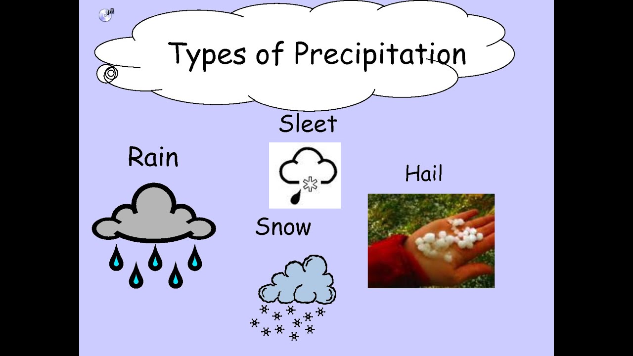
The type of precipitation that lands on your head depends on how cold the air is between the cloud and the ground. Rainfall falls as liquid drops when air temperatures stay above freezing (). Snowfall happens when freezing air ( or lower) turns moisture into soft, flaked ice crystals. Sleet is frozen raindrops or small ice pellets created when rain freezes as it falls through a cold layer near the ground. Hailstones are hard balls of ice built inside strong, violent thunderstorm clouds (Cumulonimbus) that toss ice up and down before it crashes to the ground.

Forms of Precipitation: Illustration of various forms of precipitation, including rain, snow, sleet, and hail, and their occurrence. - (a) Precipitation completes the loop of the Earth's natural water cycle.
- (b) Hailstones are layered balls of ice made in turbulent, powerful storm clouds.
Classification of Rainfall: Convectional, Orographic, and Cyclonic
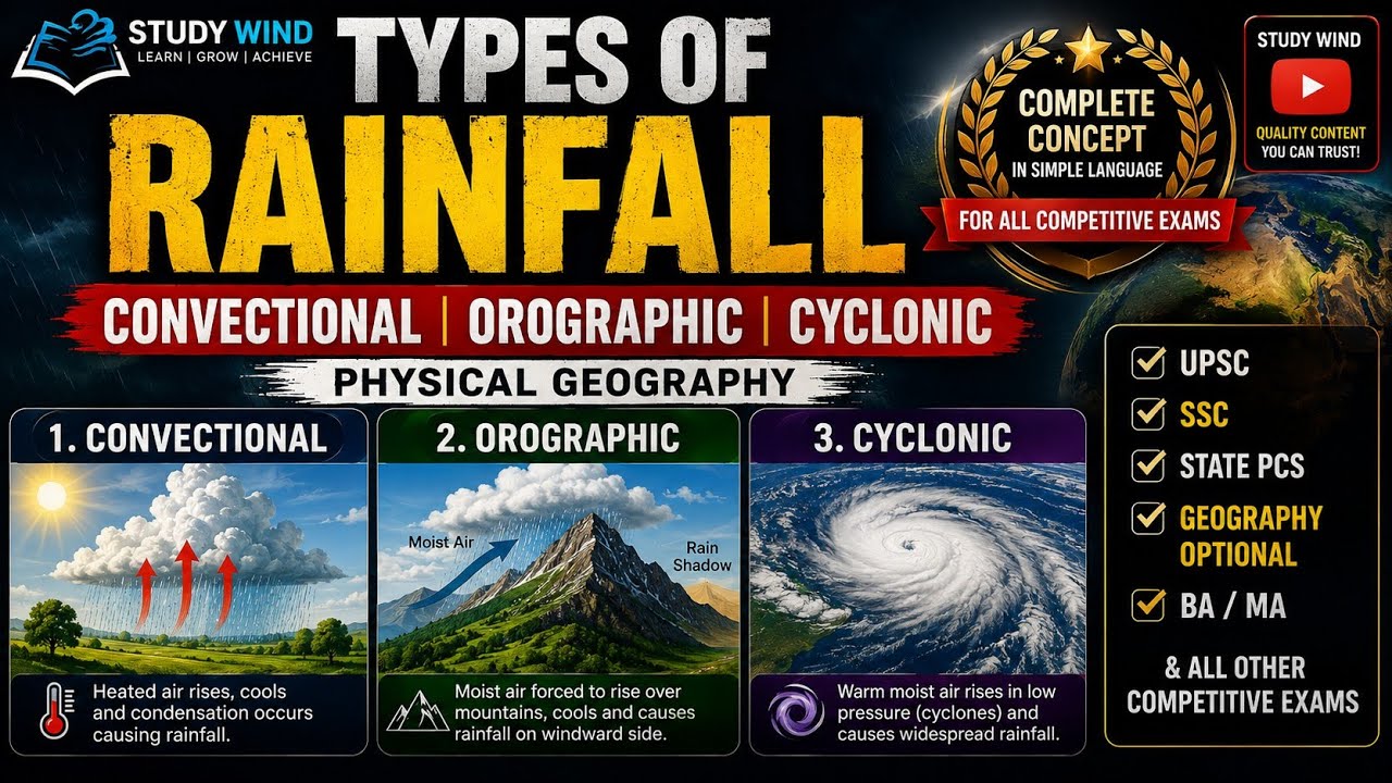
Rain is divided into three main types based on what pushes the warm air upward so it can cool down and release water drops.
Convectional Rainfall: Heat-Driven Vertical Movement
Convectional rain occurs when the strong hot sun heats up the land. Hot ground warms up the air right above it, making the air lighter so it shoots straight up like a hot air balloon. As it rises high, it expands, cools, forms fluffy cumulus clouds, and pours down heavy rain. This type of rain is short, heavy, and comes with thunder and lightning during hot afternoons, especially in warm equatorial places.

Types of Rainfall: Diagram explaining convectional, orographic, and cyclonic rainfall with their formation processes and examples. - (i) Process: Hot land heats air → Air climbs straight up → Air cools down → Heavy rain falls.
- (ii) Result: Short, intense downpours with thunder during hot afternoons.
Orographic (Relief) Rainfall: Forced Ascent over Mountains
Orographic rainfall (or relief rain) happens when moist wind hits a big mountain wall. The mountain forces the wind to climb upward. As air moves up the mountain, it cools, forms clouds, and dumps heavy rain on the side facing the wind—the windward side. After passing over the top, the drier air sinks down the other side, warming up and leaving that side dry. This dry, protected side is called the rain-shadow area.
- (a) Windward side: Receives lots of rain because rising air cools down quickly.
- (b) Leeward side: Stays very dry and is called a rain-shadow area.
Cyclonic (Frontal) Rainfall: Due to Air Mass Convergence
Cyclonic rainfall (or frontal rain) occurs when a warm, light air mass meets a cold, heavy air mass. The lighter warm air is forced to slide up and over the cold air. As the warm air rises above the cold air, it cools, forms wide cloud sheets, and produces steady rain over large regions.
- (i) Process: Warm air slides over cold air → Warm air rises and cools → Steady rain falls over large areas.
Global Patterns and Distribution of Rainfall: Major Regimes
Rainfall is not spread evenly across our planet. How much rain a place gets depends on its location on Earth, distance from oceans, and nearby mountain ranges.
Factors Influencing World Rainfall Distribution
In general, places near the hot equator get the most rain, while rainfall decreases as you travel toward the cold North and South Poles. Places near sea coasts get far more rain than land deep inside big continents. Also, mountains running along sea coasts catch moist sea winds, causing heavy rain on coastlines while leaving interior land behind them dry.

World Distribution of Rainfall: Map showing global patterns of precipitation, identifying regions with varying levels of rainfall. - (i) Equator to Pole Drop: Rain is heaviest near the equator and light near the poles.
- (ii) Coasts vs. Interiors: Coastal lands stay wet while continental centers stay drier.
- (iii) Wind Belts: Westerly winds bring rain to the west coasts of mid-latitude lands between 45° and 65° latitude.
Major Precipitation Regimes Categorized by Annual Amount
Geographers divide the world into four main rain zones based on total yearly rainfall:
- Heavy Rainfall (More than 200 cm per year): Found in the rainy equatorial belt, windward mountain sides, and Asian monsoon lands.
- Moderate Rainfall (100 to 200 cm per year): Found in inland continental plains and coastal mid-latitude regions.
- Low Rainfall (50 to 100 cm per year): Found in central tropical regions and eastern inland areas.
- Very Low Rainfall (Less than 50 cm per year): Found in dry rain-shadow zones, hot desert interiors, and freezing polar lands.
Seasonal Distribution and Its Impact on Climate
Some regions, such as the equatorial zone and cool temperate coastal lands, get rain steadily all year round. Other areas get almost all their rain during one specific season (like monsoon summer rains), which shapes how local farmers grow crops.
- (i) Steady year-round rainfall supports thick, evergreen green forests and steady farming water.
⚡ Quick Revision Capsule: Water Cycle & Atmospheric Processes
Use this handy reference table to quickly review core concepts, definitions, and atmospheric phenomena before your exam.
| Atmospheric Process | Core Definition | Key Features & Key Examples |
|---|---|---|
| Evaporation | Water changes from liquid into gas (water vapour). | Requires latent heat; sped up by high heat, dry air, and strong winds. |
| Absolute Humidity | Actual mass of vapour in a volume of air (g/m3). | Changes only when actual moisture amount changes in air. |
| Relative Humidity | Percentage ratio of current moisture versus max capacity. | Highest over oceans; reaches 100% saturation at the dew point. |
| Dew & Frost | Ground-level condensation on cold surfaces. | Dew forms liquid above ; frost forms ice crystals below . |
| Clouds & Fog | Suspended water droplets on hygroscopic nuclei. | Fog is a ground cloud; cloud types include Cirrus, Cumulus, Stratus, and Nimbus. |
📝 Summary
The Earth's hydrological cycle continuously recycles water between oceans, land, and the sky through evaporation, condensation, and precipitation. Heat from the Sun evaporates water into water vapour, which rises and cools to its dew point. Condensation creates dew, frost, fog, smog, and various clouds. Eventually, when water droplets become heavy enough, they fall back down as rain, snow, sleet, or hail. Rainfall is shaped by convection, mountains, and fronts, distributing water across different climate zones around the globe throughout as documented in classic studies like Fundamentals of Physical Geography.
🚀 Quick Revision Points
Essential facts to review before examinations:
- (i) Evaporation transforms liquid water into gas by absorbing heat energy.
- (ii) Relative humidity reaches 100% when air cools down to its dew point.
- (iii) Orographic rainfall creates wet windward mountain slopes and dry leeward rain-shadow zones.
- (iv) Cumulonimbus clouds bring heavy thunderstorm downpours, lightning, and hailstones.
- 💡 Exam Tip: When answering questions about rainfall, always explain the rising mechanism (convection, mountain barrier, or weather front) and draw a simple windward vs. rain-shadow mountain diagram for extra marks!
❓ Frequently Asked Questions (FAQ)
Q1: What is the main difference between absolute humidity and relative humidity?
A1: Absolute humidity measures the exact weight of water vapour in a volume of air, whereas relative humidity is a percentage showing how full the air is compared to its maximum capacity at that temperature.Q2: How does frost form instead of dew on cold nights?
A2: Dew forms as liquid droplets when air cools down above freezing (). Frost forms as delicate ice crystals when air cools down below freezing point (), causing gas to turn directly into ice.Q3: What causes a rain-shadow region to stay dry?
A3: Moist air is forced to climb up the windward side of a mountain, where it cools and drops its rain. As the air crosses over to the leeward side, it descends, warms up, and holds onto its remaining moisture without raining, creating a dry rain-shadow area.