
The Himalayan Mountain System represents one of the most remarkable results of plate tectonic activity, where the Indian Plate crashed into the Eurasian Plate. This massive, slow-motion crash created a huge variety of landforms across Asia — stretching all the way from the high Tibetan Plateau down to the flat, fertile Indo-Gangetic Basin. Learning how these mountains formed, how they are built, and why they matter is essential for geography learners and competitive examination preparation.
🎯 In this chapter, you will understand:
- How plate collisions created the Himalayas, the Tibetan Plateau, and major structural zones.
- The key features of tectonic boundaries like the Indus–Tsangpo Suture Zone, Main Central Thrust, and Main Boundary Fault.
- The physical differences between the Tethyan, Greater, Lesser, and Shiwalik mountain ranges.
- How river deposits formed the productive Indo-Gangetic Basin at the base of the mountains.
💡 Why this topic matters: Understanding Himalayan geography explains Asia's climate patterns, river systems, earthquake zones, and agricultural lands.
🧠 Core Idea: The Himalayas are dynamic young fold mountains created by continental collision, structured in parallel ranges separated by major tectonic fault lines.
Formation and Structure of the Himalayan Ranges: A Geological Overview
The story of the vast high altitude lands starts with immense tectonic pressure generated during mountain-building events known as orogeny.
Although the elevated Tibetan Plateau is not strictly part of the main Himalayan mountain chain, it plays a central role in shaping the region's physical features and weather systems.
- (i) It is widely nicknamed the “Roof of the World” because it sits at such an extraordinarily high average altitude.
- (ii) Formed indirectly when tectonic plates smashed together, it acts as a massive wall that alters global wind flow and drives monsoon rains.
- (iii) The plateau stops freezing northern arctic winds from pushing into the Indian subcontinent, which keeps regional weather warmer and heavily influences rainfall.
Indus–Tsangpo Suture Zone (ITSZ): The Line of Collision
The Indus–Tsangpo Suture Zone marks the exact line on the ground where the drifting Indian Plate originally hit the Eurasian Plate millions of years ago.
Geological Characteristics of the ITSZ
This long fault line extends roughly across Asia, reaching from the deep Indus Gorge in the west to the Tsangpo Gorge in the east, serving as a clear record of heavy Earth crust squeezing.
- (i) Because the pressure here was so intense during collision, solid underground rock layers were crushed and pulverized into fine bits.
- (ii) The area mainly contains ancient metamorphic rock layers along with old rock formations from the .
- (iii) Famous rivers like the Indus and the Tsangpo flow right along this structural break, carving out steep, dramatic valleys.
Tethyan Himalayas: The First Uplift
The elevated Tethyan Himalayas represent the very first stage where land squeezed upward out of an ancient ocean basin called the Tethyan Geosyncline.
Formation and Composition
This region rises up to an average height of about and stays tightly squeezed against the Higher Himalayas without any wide valley separating them.
- (i) The range is made up mostly of folded sediment layers that once sat under ocean water, alongside changed metamorphic rocks.
- (ii) It clearly displays how strong pushing forces bent and crumpled rock layers into tight folds.
- (iii) Geological studies show that this area was the earliest part of the entire Himalayan network to rise above sea level.
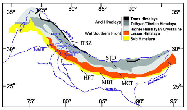
Cross-section and terrain view of the Tethyan Himalayan rock layers.
Greater Himalayas: The Lofty Backbone
The imposing Greater Himalayas, historically called the Himadri Range, form the highest, most towering central ridge of the mountain system.
Key Structural and Physical Features
Spanning an impressive length of over between peak landmarks from Namcha Barwa in the east to Nanga Parbat in the west, this chain holds many of the highest mountain peaks on Earth.
- (i) The mountains maintain an average altitude of 6000 m, with prominent individual summits rising well past 7000 m.
- (ii) The landscape is defined by steep, vertical cliffs, deep river channels called gorges, and smooth upward-curving ridge shapes.
- (iii) The interior core is made of a massive, hard igneous rock mass known as a granitic core (batholith), surrounded by altered metamorphic and layered sedimentary rocks.

Towering snow-capped peaks and deep granite-based structures of the Himadri Range.
Main Central Thrust (MCT): The Tectonic Divide
The Main Central Thrust is an exceptionally important fault line in the Earth's crust that divides the higher Greater Himalayas from the lower Lesser Himalayas.
Characteristics and Valleys of MCT
This major crack line is where massive sections of rock were shoved over one another, creating fractured ground and forming distinct mountain valleys.
- (i) It functions as a squeezed valley boundary filled with ground-up, broken rock pieces.
- (ii) Famous settlements sit along this zone, including the Kathmandu, Kashmiri, Kulu, and Kangra valleys.
- (iii) Some valleys run straight across the mountains like Kulu, while others like Kangra and Manali run parallel; because the fault is active, these regions experience frequent earthquakes.

Map depicting structural thrust lines including the Main Central Thrust across the Himalayas.
Lesser Himalayas: The Middle Range
The central Lesser Himalayas serve as a middle stepping-stone range located between the giant peaks of the Himadri and the lower foothill chains.
Physical and Structural Characteristics
Running for approximately with a typical height averaging around , this range exhibits a highly complex mixture of rock formations.
- (i) The ridges line up almost perfectly parallel to the main northern Greater Himalayan chain.
- (ii) It features notable parallel chains such as the Pir Panjal and Dhaula Dhar, along with cross-cutting ridges like Mussourie and Nagtiba.
- (iii) People call this chain the Mahabharatha Range across Nepal, while in eastern areas like Arunachal Pradesh it is broken into the Dafla–Miri–Abor Hills.

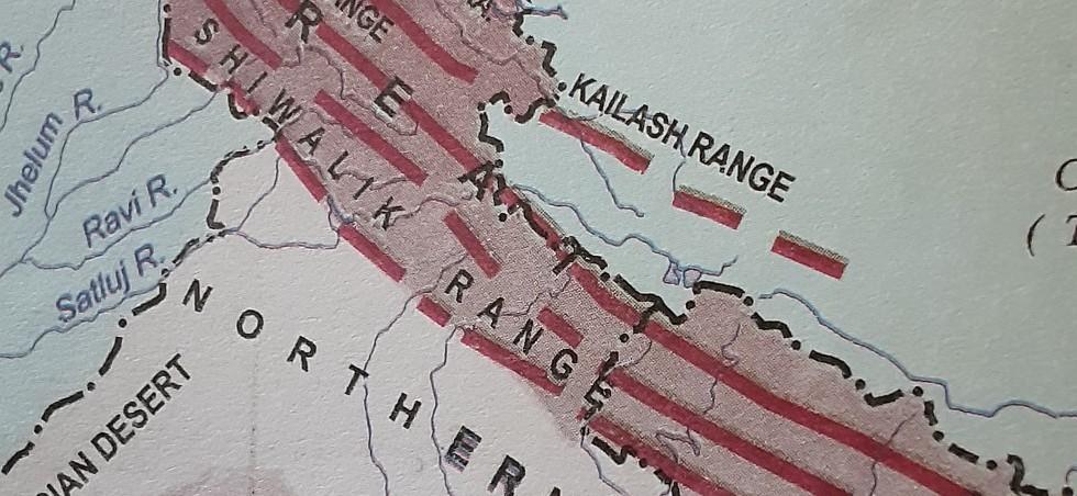
Geographical distribution of the Lesser Himalayan mountain ridges. 
Comparative map layout of the parallel Himalayan range systems.
Main Boundary Fault (MBF): The Zone of Transition
The deep Main Boundary Fault separates the middle Lesser Himalayas from the lower outer Shiwalik Hills, creating another major structural boundary.
Features and Doons
While not going as deep into the Earth as the MCT line, this fault area features broad flat-bottom valleys filled with ancient mud and lake beds termed lacustrine deposits.
- (i) Well-known local valley examples formed here include Dehra Dun and Patli Dun.
- (ii) Local communities call these flat longitudinal valleys Doons across western and central regions, whereas in the eastern sectors they are called Duars.
- (iii) Geologists classify these faulting structures as wide-angle reverse faults created by strong side-to-side pushing forces.
Shiwaliks: The Outer Foothills
The outer Shiwalik Range makes up the southernmost foothills of the mountain system, built almost entirely from loose river mud and gravel deposits called fluvial deposits.
Formation and Characteristics
Standing at a modest average elevation ranging between and , the Shiwalik hills were built over time as big mountain rivers dropped mud into a wide sinking basin.
- (i) The hills are famous for steep-sided ridge shapes known as hogback topography, dropping abruptly down to meet the flat Gangetic Plains.
- (ii) These outer hills go by local names like the Churiaghat Hills in Nepal and the Mishmi–Abor–Dafla Hills further east in Assam.
- (iii) As you move closer to the main flow of the River Ganges, these outer ridges gradually smooth out and disappear into flat land.
The outer Shiwalik foothills consisting of river-deposited sediments.
Himalayan Frontal Fault (HFF): The Final Compression Line
The Himalayan Frontal Fault forms the precise boundary line where the lowest mountain foothills end and the flat Gangetic Basin begins.
Features and Significance
This broad-angled fault plane represents the final compressional boundary produced by mountain-building forces pushing southward.
- (i) It marks the southernmost boundary line where active tectonic squeezing from the Himalayas can be detected.
- (ii) It plays a crucial role in forming flat step-like landforms called river terraces and sculpting the flat plains right next to the hills.
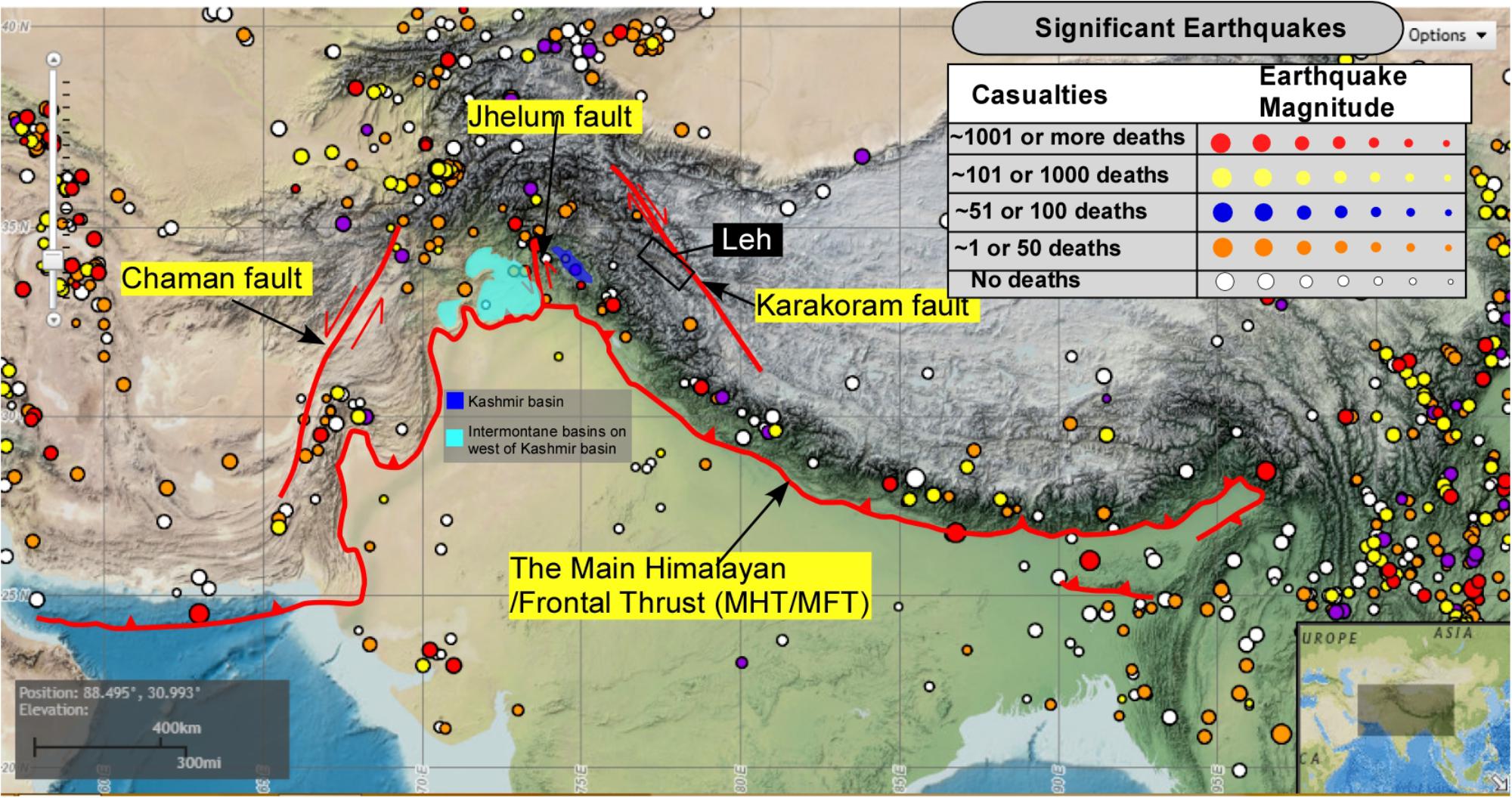
Diagram showcasing the Himalayan Frontal Fault dividing foothills from flat plains.
Indo-Gangetic Basin: The Himalayan Foredeep
The wide Indo-Gangetic Basin is a vast, flat plain created at the foot of the mountains through thousands of years of river sediment deposition.
Formation and Importance
This huge lowland area sits right between the high Himalayas to the north and the old Peninsular Plateau to the south, forming India's most productive farming land.
- (i) It was completely filled over time by rich mud brought down by huge river networks like the Ganges, Indus, and Brahmaputra systems.
- (ii) Packed with deep, fertile alluvial soils, it supports massive amounts of agriculture and feeds millions of people.
- (iii) Historically, these fertile, well-watered plains served as the direct birthplace for great historical civilizations and cultural development across South Asia.
⚡ Quick Revision Capsule: Himalayan Tectonic Zones
A quick comparison overview of the distinct geological zones and structural divisions across the Himalayan mountain system:
| Zone / Region | Key Structural Features | Geological Significance |
|---|---|---|
| Tibetan Plateau | Extensive high-altitude plateau north of the main mountain axis. | Acts as a massive atmospheric barrier influencing global climates and monsoons. |
| Indus–Tsangpo Suture Zone (ITSZ) | Crushed rock belt stretching over . | Marks the exact collision boundary between the Indian and Eurasian tectonic plates. |
| Tethyan Himalayas | Elevated sedimentary layers rising up to . | Represents the earliest marine sediment upliftment from the ancient Tethyan Geosyncline. |
| Greater Himalayas (Himadri) | Highest chain averaging elevation with a granitic batholith core. | Forms the highest mountain backbone containing the world's loftiest peaks. |
| Main Central Thrust (MCT) | Major compression fault zone separating Himadri from the Lesser Himalayas. | Houses famous valleys like Kathmandu and Kashmir; highly prone to earthquakes. |
| Lesser Himalayas (Middle) | Parallel ranges averaging elevation including Pir Panjal and Dhaula Dhar. | Acts as a intermediate transitional mountain zone with complex structural folds. |
| Main Boundary Fault (MBF) | Reverse fault line dividing Lesser Himalayas from outer foothills. | Features flat lake-bed valleys called Doons (e.g., Dehra Dun) and Duars. |
| Shiwalik Range | Outer foothills () composed of river sediments. | Displays sharp hogback topography formed by accumulated mountain erosion debris. |
| Indo-Gangetic Basin | Flat alluvial lowland created by major river systems. | Serves as the fertile agricultural foredeep cradle for South Asian civilizations. |
📝 Summary
The entire Himalayan Mountain System — stretching seamlessly from the high Tibetan Plateau down to the rich Indo-Gangetic Basin — provides a classic real-world example of powerful plate tectonics altering the surface of our planet over . Understanding how these mountain layers shifted, cracked, and built up gives learners essential knowledge about geographical features, earthquake risks, climate patterns, and soil distribution across South Asia.
🚀 Quick Revision Points
Essential facts to review before examinations:
- (i) The Himalayas were created by the tectonic collision of the Indian Plate and the Eurasian Plate.
- (ii) The Indus–Tsangpo Suture Zone marks the precise boundary line where both plates met.
- (iii) The Greater Himalayas house a hard granitic core and contain the highest mountain summits.
- (iv) Flat-bottomed longitudinal valleys in the MBF zone are locally named Doons in the west and Duars in the east as documented in geographical studies like Geomorphology of India.
- 💡 Exam Tip: Memorize the order of tectonic boundary thrusts from north to south: ITSZ → MCT → MBF → HFF. This sequence is frequently tested in geography examinations!
❓ Frequently Asked Questions (FAQ)
Q1: What tectonic plates collided to form the Himalayas?
A1: The Himalayas were formed when the Indian Plate moved northward and collided into the Eurasian Plate, crumpling the intervening ocean floor upward.Q2: What is the difference between Doons and Duars?
A2: Both are longitudinal valleys formed along the Main Boundary Fault filled with lake sediments. They are called Doons (like Dehra Dun) in the western Himalayas and Duars in the eastern region.Q3: What role does the Main Central Thrust (MCT) play in Himalayan geology?
A3: The Main Central Thrust is a major fault plane separating the Greater Himalayas from the Lesser Himalayas, creating crushed rock zones and holding important valleys like Kashmir and Kathmandu as described in structural geology literature like Tectonics of the Himalayas.
