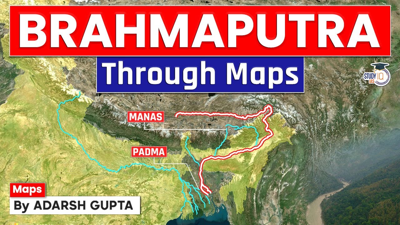
The Brahmaputra Plains, also recognized as the Assam Valley or Assam Plain, forms a constantly changing land and water corridor in northeastern India. This broad alluvial basin—a flat area created by layers of river silt—is shaped by the Brahmaputra River System, which is one of the largest river networks on Earth by water volume. Learning about its physical size, changing river slopes, specific tributary behaviors, and heavy monsoon water flow is key to understanding the environment and daily life of this important region.
🎯 In this chapter, you will understand:
- The geographical extent and landscape features of the Brahmaputra Plains from Sadiya to Dhubri.
- The national and state-wise distribution of the Brahmaputra river catchment area.
- How sudden slope changes transform the river from a fast stream into a wide, braided system.
- The key structural differences between the northern and southern tributaries that feed into the main river.
💡 Why this topic matters: The Brahmaputra River System controls the water resources, soil fertility, and recurring seasonal flood challenges of northeastern India, making it a critical subject in physical geography.
🧠 Core Idea: High Himalayan rainfall and sudden terrain flattening convert the powerful Brahmaputra River into a broad, braided waterway filled with river islands and unique sediment dynamics.
📌 Geographic Profile of the Brahmaputra Plains (Assam Valley)
The overall land area of the Brahmaputra Plains spreads across a clear natural corridor, stretching from the Assam-Arunachal Border in the east down to the Assam-Bangladesh Border in the west. The land naturally slants gently downward from East to West. Geographically, this huge plain starts at Sadiya in Assam and ends near Dhubri near Bangladesh, creating one continuous landform that shapes the physical landscape of the entire Northeastern region of India. This plain is well known as the most fertile stretch of land in Northeastern India. It is famous for special river features like numerous tributaries (smaller rivers flowing into a main river), meandering river patterns (curving river bends), oxbow lakes (U-shaped lakes formed when a river loop is cut off), marshy lands, and giant riverine islands (islands formed inside a river). A wonderful example of caring for this local nature is Jadav Payeng, who is widely known as the Forestman of this region. Working on his own, he planted and grew a vast forest covering 550 hectares inside this very ecosystem. For his incredible contribution to nature, he was officially honored with the prestigious Padma Shri award.
Features of Brahmaputra Valley and Drainage Area Distribution
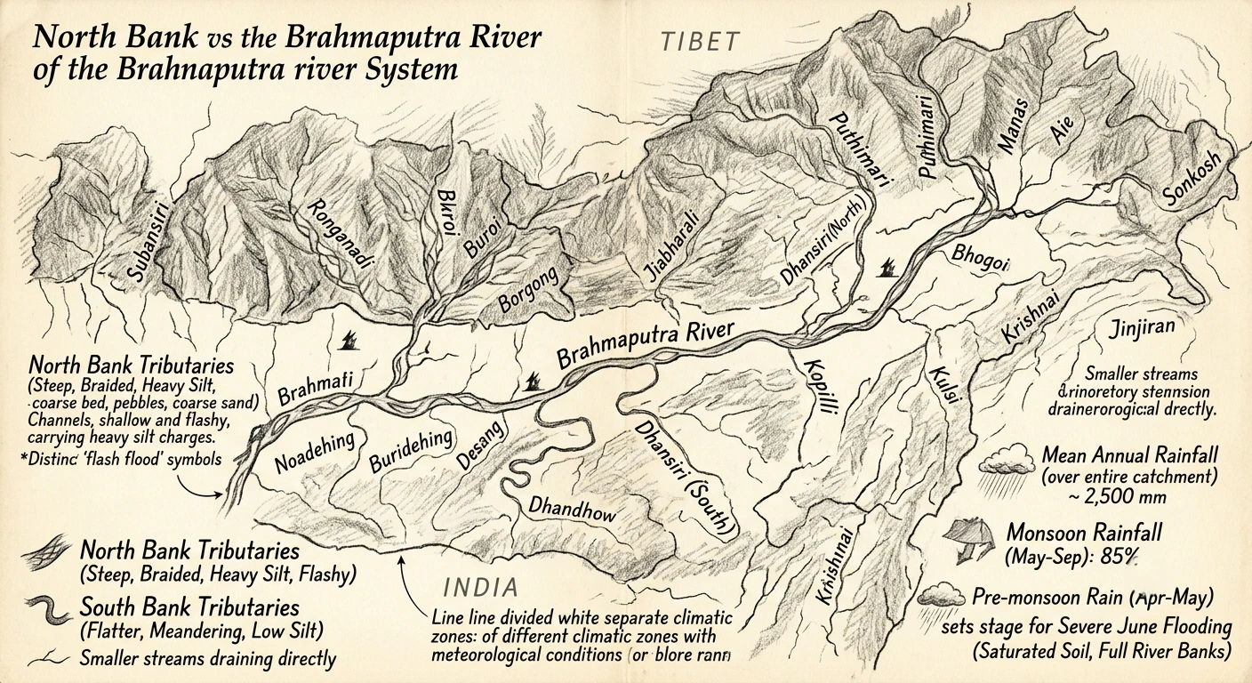
The Brahmaputra Valley maintains an average width of roughly 80 Km across its length. The main river running through this valley, the Brahmaputra, ranks as the fifth largest river globally based on its average volume of flowing water. Starting high up in the Kailash ranges of the Himalayas at a towering altitude of 5,300 M, the river flows across multiple countries. After winding through Tibet, it enters India through Arunachal Pradesh, moves through the flat valley of Assam, passes into Bangladesh, and finally empties into the Bay of Bengal.
Explore the Catchment Data and State-Wise Drainage Area
The total area of land that drains into the river system, known as the river basin, stretches across multiple nations. The entire catchment area of the Brahmaputra covers 5,80,000 Sq. Km up to its final merging point inside Bangladesh. This overall footprint is shared internationally: 2,93,000 Sq. Km sits in Tibet; 2,40,000 Sq. Km is shared between India and Bhutan; and 47,000 Sq. Km lies within Bangladesh. Looking strictly inside India, the river basin covers 194,413 Sq. Km, which makes up about 5.9% of the total land surface of India. This Indian section is bounded by natural high grounds: the Himalayas sit to the north, the Patkai range of hills along the Assam-Burma border lies to the east, the Assam range of hills bounds it from the south, and the Himalayas together with a land ridge separate it from the Ganga river basin to the west. The soil across this basin consists mainly of red loamy soil and alluvial soil, alongside mixtures of sandy, loamy, clayey soils, and laterite soils. The total farmable or culturable land inside this sub-basin is estimated at roughly 12.15 M. ha, which represents 6.2% of all culturable land in India.
📌 Hydrology and Braiding Dynamics of the Main River Course
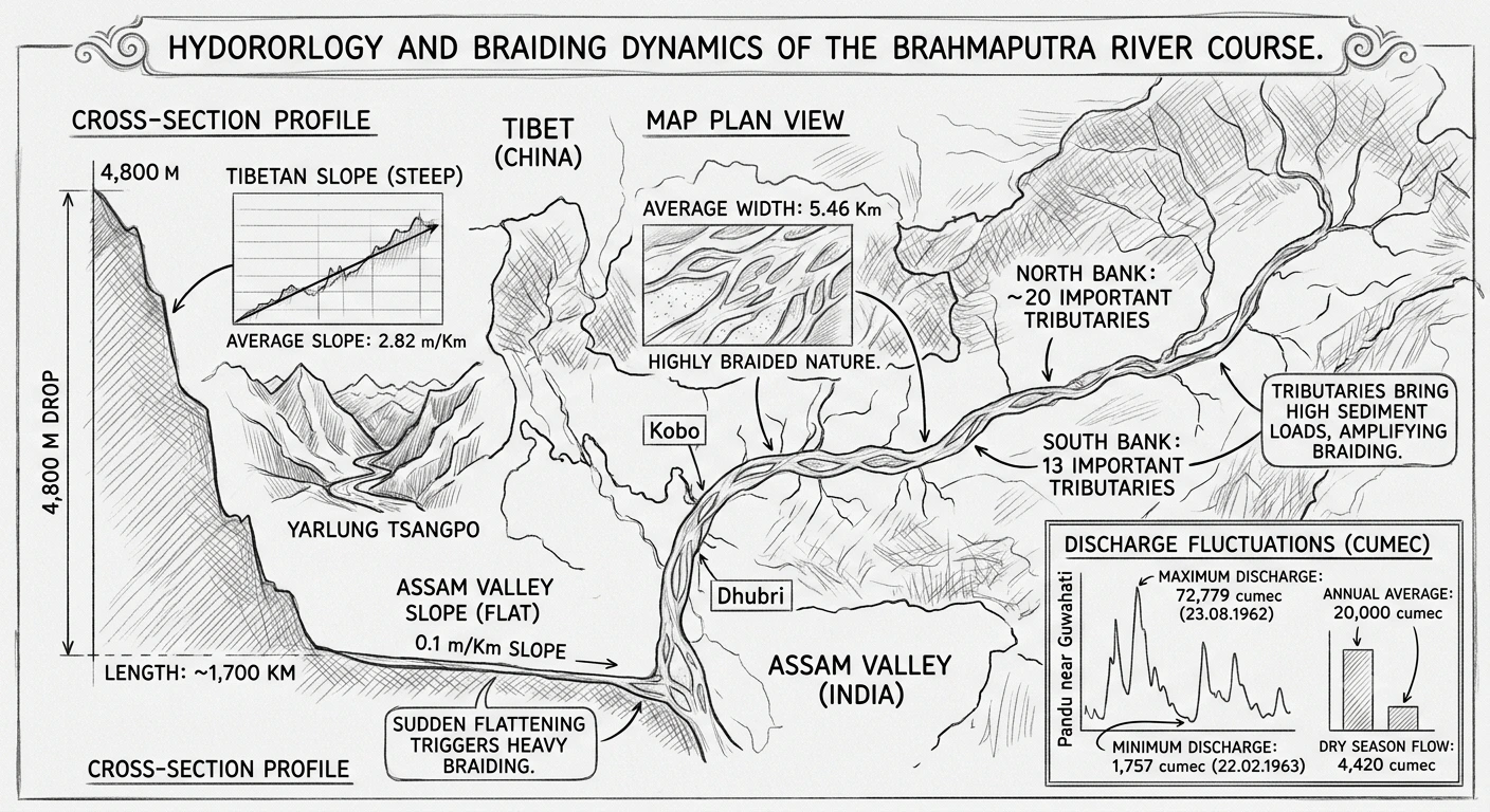
The main stream of the Brahmaputra has a broad average channel width of 5.46 Km. The amount of water passing through it changes greatly between the dry months and the heavy rain seasons. At Pandu near Guwahati, the highest ever flood flow (maximum discharge) was measured at 72,779 cumec (cubic meters per second) on . On the other hand, the lowest water level (minimum discharge) dropped to just 1,757 cumec on . Throughout a normal year, its average flow sits around 20,000 cumec, while during dry months, the flow drops to an average of 4,420 cumec.
Analyze the Discharge Figures and Slopes from Tibet to Assam
The extreme shift in mountain height changes how the river flows when entering India. The river bed drops very steeply while flowing inside China (Tibet), falling about 4,800 M over a distance of nearly 1,700 Km, creating a steep average slope of 2.82 m/Km. However, as soon as the river enters the Assam valley, this slope flattens out dramatically to only 0.1 m/Km. Because the ground suddenly flattens, the fast-moving water slows down and loses force. This causes the river to split into multiple crisscrossing channels separated by sandbars, creating a classic braided river pattern. As it flows down the valley from Kobo to Dhubri, the main stream is joined by 20 important tributaries coming from the North bank and 13 important tributaries from the South bank. These incoming side rivers dump massive loads of heavy sand and mud into the main channel, actively driving and worsening this continuous river braiding process.
📌 Characteristics of North and South Bank Tributaries and Flood Problems
All the feeder rivers filling the valley depend entirely on rainfall and expand rapidly during heavy storms. Most of this water comes from the South West monsoon, which brings heavy rain concentrated between and . Each tributary experiences its own flood surges based on local rainfall in its mountain origin. When peak flood water from these side rivers hits the main channel at the exact same time as the Brahmaputra's own peak water crest, it creates massive, devastating floods across the surrounding plains.
Distinguishing North Bank vs South Bank Tributaries
The behavior and physical traits of the northern and southern tributaries differ greatly due to the unique mountain terrain where they originate:
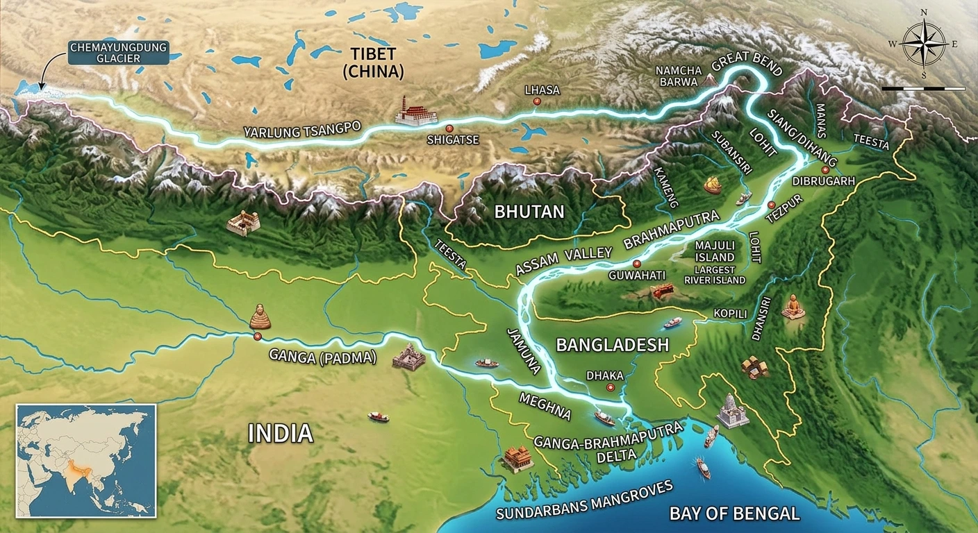
- (i) North Bank Tributaries: These rivers come down steep mountain slopes and run through shallow, split channels over long distances starting right from the foot of the hills. They flow over river beds filled with boulders, pebbles, and coarse sand. Because of their fast, steep flow, they carry massive amounts of heavy silt and cause sudden, unpredictable floods. Key examples include the Subansiri, Ronganadi, Dikrong, Buroi, Borgong, Jiabharali, Dhansiri (North), Puthimari, Manas, Beki, Aie, and Sonkosh.
- (ii) South Bank Tributaries: These rivers flow down much flatter ground and form deep, winding (meandering) single channels starting almost right from the foothills. As a result, they carry far less mud and silt. Key examples include the Noadehing, Buridehing, Desang, Dikhow, Bhogdoi, Dhansiri (South), Kopilli, Kulsi, Krishnai, Dhdhnoi, and Jinjiran.
Beside these main systems, many smaller streams flow directly into the main river channel. Weather conditions vary between the mountain origins in Tibet and the plains of India because they sit in different climate zones. The average annual rainfall measured across the entire basin (including Tibet and Bhutan) is about 2,500 mm, with 85% of this water pouring down during the monsoon months from to . Furthermore, pre-monsoon thunderstorms hit the valley in and , soaking the ground completely and filling the river banks so that heavy rains in instantly trigger extreme flooding.
⚡ Quick Revision Capsule: Brahmaputra Basin State-Wise Drainage Area
The total area of the Brahmaputra drainage basin located within India measures 194,413 Sq. Km, which is distributed across six northeastern states as detailed below:
| State Name | Drainage Area (Sq. Km) | Share Characteristics |
|---|---|---|
| Arunachal Pradesh | 81,424 | Largest state share; entry point of main river from Tibet. |
| Assam | 70,634 | Contains the core 80 Km wide main valley and braided channels. |
| West Bengal | 12,585 | Includes northern sub-tributaries like the Teesta and Sonkosh basins. |
| Meghalaya | 11,667 | Feeds major southern bank tributaries like the Kopilli and Kulsi. |
| Nagaland | 10,803 | Drains eastern hill ranges into the Dhansiri (South) system. |
| Sikkim | 7,300 | High mountain catchment feeding glacial melt water into tributaries. |
📝 Summary
The Brahmaputra River Basin and Plains form a distinct geographic landform in northeastern India. The river drops dramatically from high Himalayan mountains in Tibet down into a flat, 80 Km wide valley in Assam. Driven by powerful monsoon seasons that bring an annual average rainfall of 2,500 mm between and , the river system relies on a vast network of steep, silt-heavy North bank tributaries and flatter, winding South bank tributaries. Together, these rivers create an exceptionally fertile plain that faces recurring, intense seasonal flooding whenever peak river surges combine.
🚀 Quick Revision Points
Essential facts to review before examinations:
- (i) The valley stretches horizontally across an average width of 80 Km, sloping downwards from East to West between Sadiya and Dhubri.
- (ii) The total multi-national basin covers 5,80,000 Sq. Km, with India holding 194,413 Sq. Km (representing about 5.9% of India's overall land mass).
- (iii) The slope of the river drops from 2.82 m/Km in Tibet down to just 0.1 m/Km in Assam, triggering its broad braided river shape.
- (iv) Seasonal monsoon rains deliver 85% of annual precipitation, creating major flood threats when tributary peak flows align with the main river.
- 💡 Exam Tip: Pay special attention to the stark contrast between North and South bank tributaries regarding slope steepness, channel depth, and silt capacity when answering regional hydrology questions.
❓ Frequently Asked Questions (FAQ)
Q1: Why does the Brahmaputra River become braided in the Assam Valley?
A1: The river slope drops rapidly from an average of 2.82 m/Km in Tibet down to 0.1 m/Km inside the Assam valley. This sharp loss of speed, paired with huge amounts of heavy mud and sand brought in by 20 North bank and 13 South bank tributaries, forces the water to split into crisscrossing channels.Q2: What are the main differences between the North bank and South bank tributaries?
A2: North bank tributaries have steep slopes, shallow braided beds, coarse boulder bottoms, carry heavy mud loads, and cause sudden flash floods. South bank tributaries have flatter slopes, deeper winding beds, and carry far less silt sediment.Q3: What historical discharge extremes have been recorded for the Brahmaputra River?
A3: The highest recorded peak flow (maximum discharge) reached 72,779 cumec at Pandu near Guwahati on , while the lowest recorded flow (minimum discharge) dropped to 1,757 cumec on .
Important links for this article includes Water Resources page of Assam Government. Click here to visit page