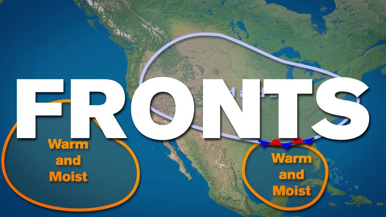
The study of Air Masses and Frontogenesis stands as a cornerstone of modern meteorology, functioning as a vital tool used by climatologists to ensure accurate weather prediction. Historically, understanding their significance reached a peak during the with the development of dynamic forecasting. It served a dual purpose: managing disaster preparedness by tracking severe storms while securing a guaranteed observational record of atmospheric circulation. By tracking how these air systems keep their temperature and moisture profiles over long distances, this meteorological framework gives us the predictive stability needed for national agricultural planning and aviation safety during changing seasons.
🎯 In this chapter, you will understand:
- How huge air bodies form uniform temperature and humidity traits over vast source regions.
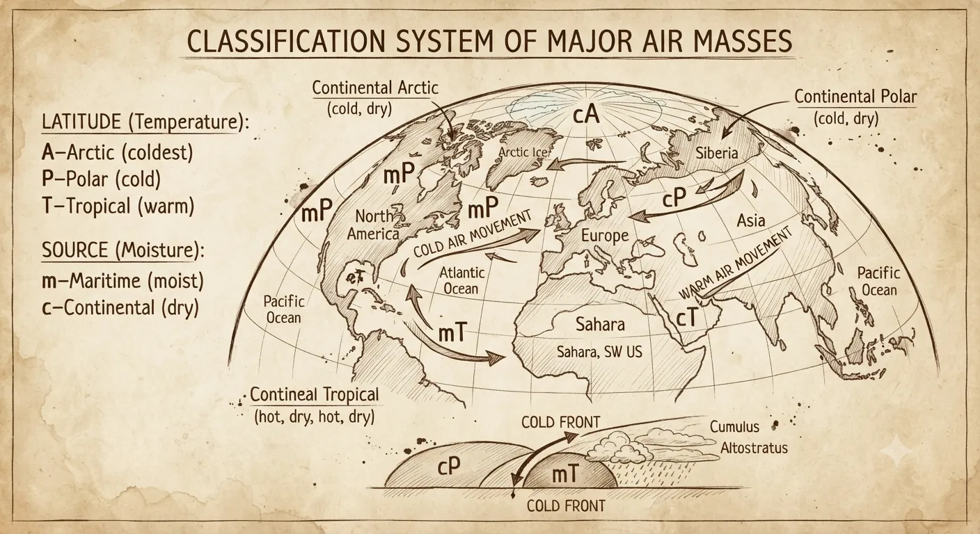
- The physical classification system that separates continental and maritime air masses.
- The process of frontogenesis where opposing thermal currents meet to build frontal boundaries.
- How frontal lifting triggers cloud development, rainfall patterns, and global energy balance.
💡 Why this topic matters: Understanding atmospheric boundaries explains how localized weather changes suddenly and how the planet redistributes surplus heat from equator to poles.
🧠 Core Idea: Huge pools of air take on the climate traits of their home surfaces, and when these different air pools bump into each other, they form weather fronts that generate clouds and storms.
The Narrative of Atmospheric Stability: Defining Air Masses
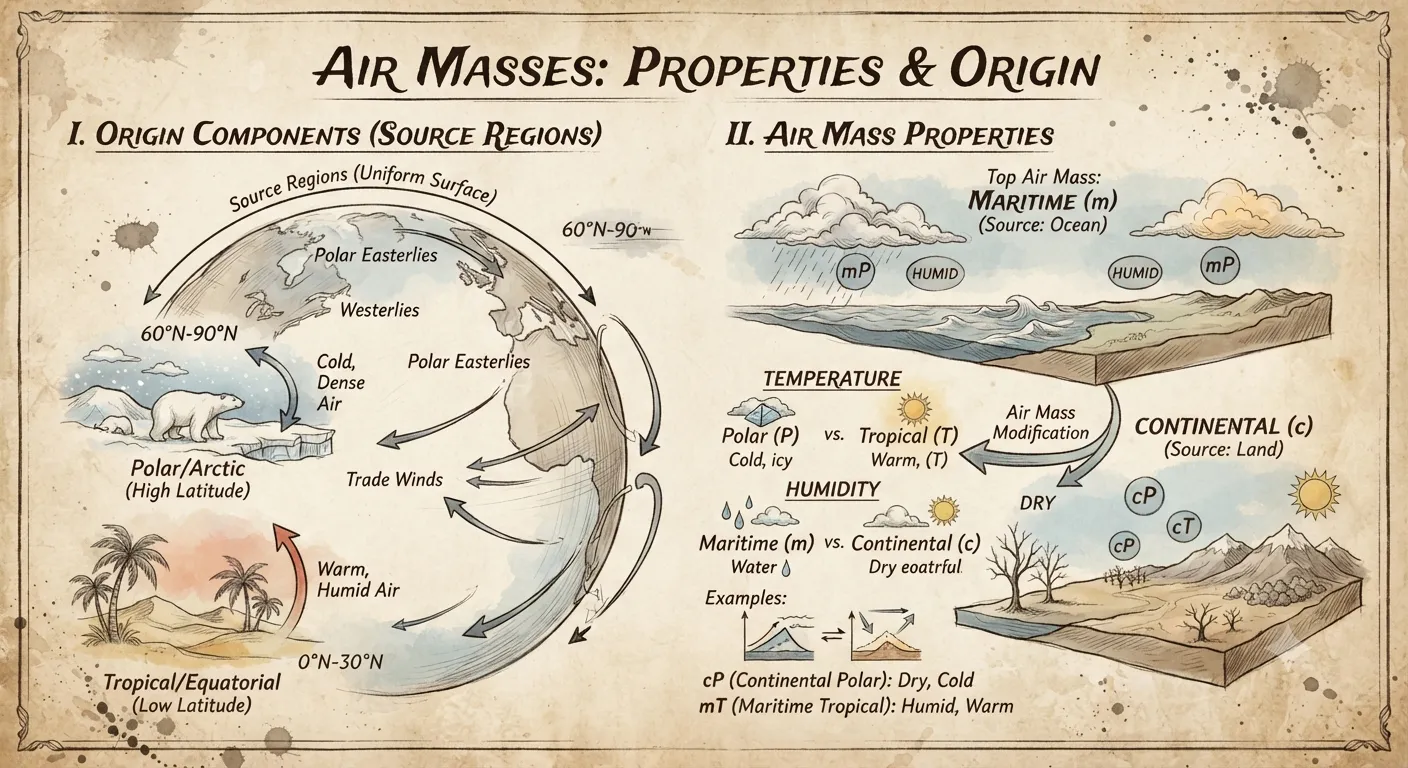
In atmospheric science, an air mass acts like a giant blanket of air with similar weather conditions throughout its entire body. Unlike quick local winds, these giant air volumes sit over a surface for days to soak up matching warm or cold, wet or dry traits.
Analyze the Definition and Core Classifications of Air Masses
In simple terms, an air mass is a huge volume of air that has roughly the same temperature and humidity throughout. When it rests over a large area, it acts as a regulatory valve that helps manage heat distribution across the globe.
Explore the Mechanics of Source Regions and Properties
Under the climatological mandate, an air mass must match the ground or ocean traits of where it formed. These geographic origin areas are called source regions, and they include maritime environments over oceans and continental surfaces over land. For instance, when a high-pressure system sits still over a dry desert, it builds warm, dry air that creates a powerful drying effect downwind. This movement influences mid-latitude weather by carrying cold polar air toward temperate zones.
- (i) Maritime boundaries provide an immediate source of moisture for precipitation events.
- (ii) Continental source blocks ensure extended dry spells for underlying territories.
- (iii) Tropical source locations drive warm air poles, regulating global temperature balance.
- (iv) Polar source landscapes generate dense, chilling air layers that drop regional thermometers.
Deep Dive into Frontogenesis and Frontal Boundaries
The active zones where different air masses meet are places of intense dynamic regulation. Nature uses frontogenesis—the creation and strengthening of weather fronts—to move heat and kinetic energy across the globe without upsetting planetary energy balance.
Chronicle of Frontal Classifications and Meteorological Behaviors
The life cycle of weather fronts shows how converging winds interact. When cold fronts push forward, they slide under warm air like a wedge and force it upward rapidly. When warm fronts move in, the light warm air gently climbs over the colder air ahead. After winds shift speed and pressures drop, an system creates an occluded front where cold air traps warm air up off the ground.
- (i) Cold Fronts occur when heavy, cold air wedges beneath warm zones, triggering storms.
- (ii) Warm Fronts establish steady, long-lasting cloud layers as light air rises gradually.
- (iii) Stationary Fronts develop when stalling wind currents keep opposing air masses deadlocked.
- (iv) Occluded Fronts materialize when fast cold sectors overtake slow warm boundaries completely.
According to physical rules, a sharp rise in temperature difference across a short distance is needed for active frontogenesis. This process works alongside the high-altitude jet stream, giving us the rules used in modern weather forecasting.
Aspects of Air Masses Important Data Verification Notice: Older geography textbooks that draw weather fronts as permanent fixed lines on a map are outdated. Under modern tracking standards, front boundaries are dynamic, constantly changing transition zones that adjust based on wind speed and ground friction.
Evaluate the Strategic Impact on Weather and Climate Systems
The main job of frontogenesis is the systematic balancing of heat and energy in the sky. By controlling how light and heavy air currents collide, the atmosphere keeps firm control over storm generation.
Assessing Temperature Variations, Cloud Formation, and Precipitation
The impact of frontogenesis happens in three main steps. First, it pushes warm air upward until it cools to its dew point for moisture condensation. Second, it drives cloud generation by lifting moist air into unstable sky layers. Third, it helps create low-pressure cyclonic storm development so the planet can shift extra heat from tropical zones to colder polar regions at predictable time intervals. When strong temperature contrasts occur, the jet stream speeds up frontogenesis to sweep away excess heat energy and balance global air pressure.
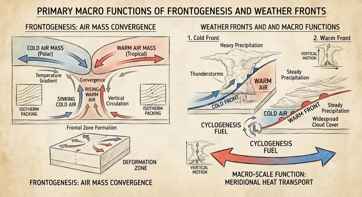
Functions of Frontogenesis
⚡ Quick Revision Capsule: Air Masses and Frontogenesis
This reference capsule compares the key features of major air masses and frontal structures across atmospheric systems.
| System Type | Core Physical Trait | Primary Weather Impact |
|---|---|---|
| Continental Polar (cP) | Cold and dry air formed over frozen land masses | Brings clear skies, low temperatures, and crisp atmospheric conditions |
| Maritime Tropical (mT) | Warm and humid air formed over warm ocean waters | Supplies heavy moisture leading to clouds, muggy weather, and rainfall |
| Cold Front | Dense cold air rapidly wedges under warm air | Triggers steep air movement, gusty winds, severe thunderstorms, and sudden temperature drops |
| Warm Front | Light warm air gently glides over retreating cold air | Produces broad cloud decks and long periods of light to moderate precipitation |
| Occluded Front | Fast cold front completely overtakes a slower warm front | Cuts off warm air at the surface, signaling mature cyclonic storm decay |
📝 Summary
The ongoing interaction between Air Masses and Frontogenesis forms a fundamental pillar of global climate structure. From early formation over ocean and land source regions to the final occluded phase in mature low-pressure storms, these atmospheric mechanisms balance heat movement with global moisture patterns. While they bring short-term stormy weather, this transfer maintains a stable equilibrium for long-term plant and animal life across all climate zones.
🚀 Quick Revision Points
Essential facts to review before examinations:
- (i) An air mass gains uniform temperature and humidity traits by sitting over a matching ocean or land surface.
- (ii) The process of frontogenesis strengthens frontal boundaries where temperature differences and converging winds meet.
- (iii) Transition states along frontal boundaries create unique cloud and rain patterns due to density differences.
- (iv) Modern meteorology uses satellite networks and thermal data to track these fronts in digital prediction models.
- 💡 Exam Tip: When answering exam questions on frontogenesis, always highlight that cold fronts feature steep slopes with short intense storms, whereas warm fronts feature gradual slopes with widespread, steady rainfall.
❓ Frequently Asked Questions (FAQ)
Q1: What are the primary criteria for a region to qualify as a source region?
A1: The area must be very large, have a uniform land or water surface, and feature light wind conditions so the air can sit long enough to adopt the temperature and moisture traits of that surface.Q2: How does frontogenesis differ from frontolysis during a storm's lifecycle?
A2: Frontogenesis is the creation or strengthening of a frontal boundary when air currents push together, whereas frontolysis is the weakening and disappearing of that boundary as temperature differences fade away.Q3: Where do maritime polar masses form compared to continental tropical ones?
A3: Maritime polar masses form over cold high-latitude oceans and bring chilly, damp air. In contrast, continental tropical masses form over hot low-latitude deserts and bring hot, dry weather.