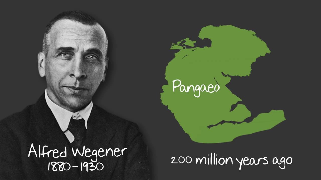
The Continental Drift Theory, created by the famous scientist Alfred Wegener in , completely changed how we understand our planet's geological history. Long ago, people believed that continents were fixed in one place forever. Wegener challenged this idea by explaining that all landmasses were once joined together into one gigantic supercontinent named Pangaea. This fundamental idea is backed up by fascinating proof, such as matching land shapes across oceans and similar fossil discoveries. Learning this story is super helpful for students preparing for UPSC and school Geography tests because it sets up the foundation for understanding the modern Plate Tectonics Theory.
🎯 In this chapter, you will understand:
- How the single ancient supercontinent broken apart into modern continents over millions of years.
- The major pieces of geological, glacial, and fossil evidence that prove continents were connected.
- The early explanations for continental movement versus modern discovery of mantle convection currents.
- How mapping the ocean floor helped explain underwater mountain ridges, deep trenches, and volcanic activity belts.
💡 Why this topic matters: It reveals how our world's maps took shape and helps us understand natural events like earthquakes and volcanoes.
🧠 Core Idea: Continents are not stuck in place; they move slowly over huge stretches of time across Earth's surface.
📌 Alfred Wegener's Continental Drift Theory: Origins, Evidence, and Geological Context (1912-1930s)
The story of how land moves across our planet began when scientists looked closely at world maps and noticed something extraordinary.
The Story of Pangaea: How Our Continents Began Their Journey.
The idea of continental drift came to life when Alfred Wegener noticed how perfectly the coastlines of continents on opposite sides of the ocean seemed to fit together. He officially shared his theory in , describing a dynamic Earth where giant landmasses slowly travel across vast stretches of time.
- (i) The giant story starts about . At that time, all of Earth's land was bunched together into one huge single supercontinent that Wegener named Pangaea, which literally means "all earth."
- (ii) This massive single piece of land, Pangaea, was completely surrounded by one enormous world ocean called Panthalassa, a word that means "all water."
- (iii) The big breakup began around . Pangaea cracked into two smaller giant continents: Laurasia in the northern half and Gondwanaland in the southern half. Over millions of years, these two masses split up even more to form the modern continents we see on maps today.

Theory of continental drift, explaining the historical movement of continents and the breakup of the supercontinent Pangaea.
📌 Compelling Geological and Biological Evidence Supporting Continental Drift
Wegener gathered several strong facts to support his idea. He turned what sounded like a crazy story into a serious scientific explanation by showing that separated continents carry matching clues from their shared past.
The Jigsaw Puzzle Fit and Matching Geological Formations
One of the easiest and clearest proofs for continental drift is how coastlines across the Atlantic Ocean match like puzzle pieces, supported by matching ages of ancient rocks.
- (i) The Matching of Continents (Jig-Saw Fit): The east coast of South America and the west coast of Africa fit together almost like two pieces of a puzzle. In , a scientist named Bullard used a computer to line up the deeper edges of these continents along the 1,000-fathom line underwater. The computer showed an almost flawless fit between them.
- (ii) Rocks of Same Age Across Oceans: Tests that measure the age of rocks show incredible matches across oceans. For example, a belt of ancient rock that is 2,000 million years old in Brazil aligns perfectly with a matching rock formation in Western Africa. Also, marine sediments from the along both coasts show that the ocean separating them did not exist before that time period.
Tillite (Glacial) Deposits and Placer Gold Continuity
The location of specific rocks and valuable mineral deposits proves that today's distant continents once shared the exact same climate zones and land connections.
- (a) Tillite (Glacial Deposits):Tillite is a special sedimentary rock made from compacted debris left behind by ancient glaciers. Massive layers of tillite found in India match identical rock layers in Africa, Madagascar, Antarctica, Australia, and the Falkland Islands. Because these rocks are spread across warm areas today, it proves these lands were once grouped near the cold South Pole in a shared glacial history.
- (b) Placer Deposits: Rich placer gold deposits found on the coast of Ghana have no local gold-bearing rocks nearby. However, the exact gold veins that created this gold are located across the ocean in Brazil. This proves that Ghana and Brazil were once side-by-side, allowing gold from Brazilian mountains to wash onto African land before they drifted apart.
Biogeographical Puzzle: Distribution of Fossils Across Separated Continents
Finding matching ancient animal and plant fossils on landmasses separated by huge oceans gives us some of the clearest proof that Pangaea really existed.

Fossil evidence supporting the theory of continental drift, showing similar species found across separated continents, providing clues about past connections. - (i) Identical species of land creatures and freshwater plants, which could never swim across vast salty oceans, are found as fossils on far-apart continents today.
- (ii) Lemurs: Fossils and living populations of these animals are found in India, Madagascar, and Africa. This led scientists to realize these places were once linked as one contiguous piece of land, sometimes referred to as Lemuria.
- (iii) Mesosaurus: Fossils of this tiny, freshwater-dwelling reptile are found only in two specific spots: the Karoo System of South Africa and the Irati Formation of Brazil. Today, these two spots are separated by 4,800 km of deep ocean water. Since this small creature could not swim across an ocean, the land must have been connected.

📌 The Driving Forces: Wegener's Hypothesis vs. Modern Geophysical Insights
Although Wegener had strong evidence showing that continents had moved, he struggled to explain the exact power source that pushed giant landmasses across the Earth. Scientists later solved this mystery after World War II.
Wegener's Polar-Fleeing and Tidal Forces
Alfred Wegener suggested two main forces to explain how heavy continents traveled across the globe over millions of years, but both were later proven to be too weak.
- (a) Polar-Fleeing Force: This idea was tied to the spinning action of the Earth. As Earth rotates, it creates a centrifugal force that makes the planet bulge around the equator. Wegener thought this outward bulge pushed continents away from the icy poles toward the equator.
- (b) Tidal Force: This involved the combined gravitational pull of the Moon and the Sun, which pulls on ocean waters to create tides. Wegener believed that over millions of years, this gentle tugging slowly dragged landmasses across the ocean. However, physics experts showed that both Polar-Fleeing and Tidal forces are far too weak to move giant landmasses.
Post-Drift Breakthroughs: Convectional Currents and Ocean Floor Mapping
In the decades following Wegener's death, new technology provided the real explanation for continental movement, paving the way for modern plate tectonics.
- (i) Convectional Current Theory: In the , a scientist named Arthur Holmes introduced a groundbreaking idea. He explained that radioactive elements deep inside Earth create immense heat inside the mantle layer. This heat causes rock material to slowly warm up, rise, cool down, and sink—creating massive circular convection currents. These moving currents act like conveyor belts that drag continents floating above them.
- (ii) Mapping of the Ocean Floor: After , scientists used sonar equipment to map the sea bottom. They discovered that the ocean floor is not flat at all. They found enormous submerged mountain chains called mid-oceanic ridges and extremely deep valleys called oceanic trenches. Surprisingly, rock tests proved that ocean floors are much younger than continents, and rocks matching on both sides of a mid-ocean ridge are identical in age and mineral makeup.
The Dynamic Configuration of the Ocean Floor Topography
Detailed seafloor maps revealed that the ocean bottom has three main physical zones that guide geological activity and continental movements.
- (a) Continental Margins: These are transitional zones connecting land masses to deep ocean floors. They consist of shallow coastal waters called the Continental shelf, a steep downward drop named the Continental slope, a gentle seabed rise called the Continental rise, and deep oceanic trenches where old crust gets pushed down and melted.
- (b) Abyssal Plains: These are vast, extremely flat plains lying deep underwater between continental edges and mid-ocean ridges. They are covered in thick layers of fine mud and sediment carried far from land.
- (c) Mid-Oceanic Ridges: Forming the longest mountain ranges on Earth, these connected underwater chains feature a central split valley called a rift system along their peaks. This central rift experiences continuous underwater volcanic eruptions, constantly churning out fresh ocean crust.
The Ring of Fire: Distribution of Earthquakes and Volcanoes
Plotting earthquake locations and active volcanoes on world maps reveals clear line patterns that highlight the edges of drifting crustal plates.

Distribution of earthquakes and volcanoes, highlighting the zones of seismic activity that correspond with plate boundaries. - (i) Earthquakes line up directly along underwater mountain ridges in the Atlantic and Indian Oceans, showing where the seabed is spreading apart.
- (ii) Shallow-focus earthquakes occur mostly along mid-oceanic ridges where plates pull apart. In contrast, deep-focus earthquakes happen in areas where plates collide, such as the Alpine-Himalayan belt and around the Pacific Ocean.
- (iii) Volcanic eruptions follow the exact same lines. A huge concentration of active volcanoes encircles the Pacific Ocean, earning this intense zone of crustal activity the famous name: the Ring of Fire.

⚡ Quick Revision Capsule: Continental Drift & Ocean Floor Mapping
This table summarizes key milestones, scientists, and geological proof associated with the movement of Earth's landmasses and seafloor features.
| Key Concept / Event | Scientist / Timeframe | Core Significance & Evidence |
|---|---|---|
| Continental Drift Hypothesis | Alfred Wegener () | Proposed that all continents were joined in a single landmass named Pangaea surrounded by Panthalassa. |
| Jigsaw Coastline Fit | Bullard () | Computer-matched continental edges along the 1,000-fathom line with remarkable precision. |
| Fossil Evidence | Discovered across distant landmasses | Identical fossils like Mesosaurus and freshwater plants found in matching strata in Brazil and South Africa. |
| Convection Current Theory | Arthur Holmes () | Explained that heat from radioactive material in the mantle drives thermal currents that push continents. |
| Pacific Ring of Fire | Post- Seafloor Mapping | High concentration of earthquakes and volcanoes outlining active plate boundaries around the Pacific Ocean. |
📝 Summary
The Continental Drift Theory created by Alfred Wegener in serves as a foundational milestone in Earth Science. By observing how landmasses fit together like puzzle pieces, examining rock formations across oceans, and identifying matching fossils like Mesosaurus, Wegener proved that landmasses move over geological timescales. Although his original explanations involving tidal and centrifugal forces were insufficient, later breakthroughs in the regarding mantle convection currents and post-war seafloor mapping provided the missing physical mechanism. Today, these discoveries form the core framework of Plate Tectonics.
🚀 Quick Revision Points
Essential facts to review before examinations:
- (i) Pangaea was the original single supercontinent that broke into Laurasia and Gondwanaland around .
- (ii) Tillite rocks prove that distant regions like India, Australia, and South America once shared an ancient glacial climate near the South Pole.
- (iii) Mantle heat from radioactive decay drives convection currents, acting as the primary engine for crustal movement.
- (iv) Ocean crust is significantly younger than continental crust and continuously forms anew at mid-oceanic ridges.
- 💡 Exam Tip: When answering exam questions about drift proof, always cite specific examples like the Mesosaurus fossil distribution, 2,000-million-year-old rock belts matching between Brazil and Ghana, and Bullard's computer matching along the 1,000-fathom line.
❓ Frequently Asked Questions (FAQ)
Q1: What was Pangaea and when did it break apart?
A1: Pangaea was a supercontinent containing all of Earth's land. It began breaking apart roughly .Q2: Why was Wegener's theory initially rejected by many scientists?
A2: Wegener proposed that tidal forces and polar-fleeing forces moved continents, but physicists proved these forces were far too weak to move heavy landmasses.Q3: What real force actually moves the Earth's continents today?
A3: Earth's continents move due to thermal convection currents inside the mantle, driven by heat from radioactive decay as explained by Arthur Holmes in the .