Embark on a simple geological journey into the Earth’s hidden deep spaces, where powerful endogenic forces (internal energy pushes) shape our whole world. This detailed guide explores the Interior of the Earth, how earthquakes move using P-waves and S-waves, and how volcanoes make spectacular volcanic landforms. Learning about the Earth's crust, mantle, and core through seismic activity (ground shaking tests) and indirect clues is very important for geography students in and beyond, helping everyone understand big events like tsunamis and natural rocks.
🎯 In this chapter, you will understand:
- How scientists learn about the deep Earth using direct samples and indirect clues like shaking waves.
- How earthquakes happen and how primary waves (P-waves) and secondary waves (S-waves) move through solids and liquids.
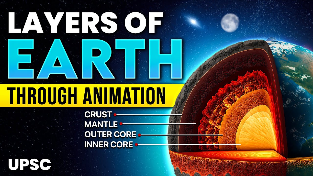
- The three main layers of our planet: the brittle crust, the hot flowing mantle, and the heavy metal core.
- The different kinds of volcanoes and the underground rock formations created when molten magma cools down.
💡 Why this topic matters: It helps us predict dangerous natural events like land sliding or earthquakes and explains how the very ground under our feet was formed.
🧠 Core Idea: We cannot dig to the center of the Earth, so we listen to ground vibrations and look at hot rocks to build a complete map of our layered planet.
📌 The Interior of the Earth, Earthquakes, and Volcanoes: A Comprehensive Geoscience Guide
Trying to understand what is deep inside the Earth is a big puzzle because humans cannot dig down very far. Our knowledge is built by carefully studying indirect clues to paint a simple picture of the inside of our planet.
Unraveling the Mystery: The Earth's Interior Through Indirect Evidence
The shape of the surface of the Earth comes from two things: outside forces like rain or wind (exogenic processes) and inside forces like underground heat pushes (endogenic processes).
- (i) Since digging straight down to the center is impossible, we look at clues like heat, squeezing weight, rock weight, and earthquake wave patterns.
- (ii) Knowing how the inside works helps us understand local land shapes and stay safe from natural disasters like shifting ground shaking.
📌 Sources of Information About the Earth's Interior: Direct and Indirect Insights
The distance from the surface to the center of the Earth is about . Scientists use two ways to learn about it: direct pieces of rock and clever indirect physics rules.
Direct Access: Surface Rocks, Deep Mining, and Exploration Drilling Projects
Direct sources give us real physical pieces of rock from the upper top parts of the Earth.
- (i) Surface Rocks and Mining: Rocks on the ground and deep gold mines in South Africa (going down to ) give us real rock samples. However, miners must stop because it gets extremely hot deeper down.
- (ii) Scientific Drilling Initiatives: Ocean drilling projects try to drill deep holes into the sea floor. The deepest drill hole in the world is at Kola in the Arctic Ocean, reaching down.
- (iii) Volcanic Eruptions: Liquid hot rock called magma comes out of volcanoes as lava, giving us real material from deep down, though we do not know its exact starting depth.
Indirect Inference: Temperature, Pressure, Meteors, and Seismic Activity
Most of what we know about the very deep inside comes from measuring physical changes that happen as you go down.
- (a) Temperature, Pressure, and Density: Heat, squeezing force, and rock weight all increase as you go deeper. Scientists calculate these changes to guess what the rock layers are like.
- (b) Meteors: Rocks that fall from space were made at the same time as planets, so studying space rocks tells us what our own planet is made of.
- (c) Gravitation and Gravity Anomalies: The pull of gravity (g) is slightly stronger at the poles and weaker at the equator because the planet is not a perfect sphere. Differences in local gravity, called a gravity anomaly, show us where heavy rocks are hidden under the ground.
- (d) Magnetic Field and Seismic Activity: Magnetic tests show where metals sit in the ground. The study of earthquake vibrations (seismology) is the most reliable clue we have for mapping the deep inner layers.
📌 Earthquakes: Mechanism, P and S Waves, and the Shadow Zone Phenomenon
An earthquake is a sudden, violent shaking of the ground. It happens when stored energy is suddenly released deep inside the planet, making energy waves travel through the Earth.
The Story of Earth Shaking: Focus, Epicentre, and Fault Lines
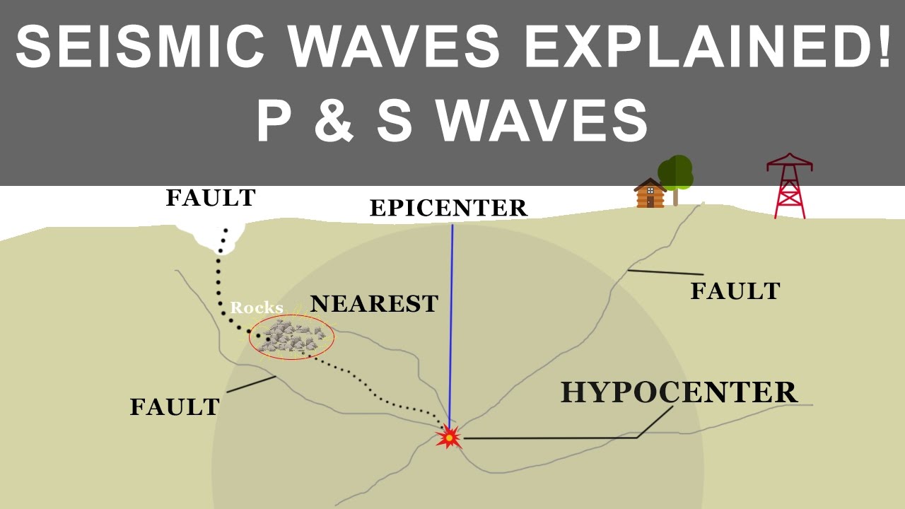
Shaking starts when rocks along a subterranean crack, called a fault, snap and slip past each other after being stuck together by friction.
- (i) Energy Release: Rocks push against each other along a fault line. When the push gets stronger than the friction holding them, they slide suddenly and send out energy waves.
- (ii) Key Terminology: The exact spot deep underground where the snap happens is called the focus (or hypocentre). The point on the surface directly above the focus is called the epicentre.
- (iii) Depth Limit: Almost all natural earthquakes happen in the top rigid outer layer called the lithosphere, usually within of the surface.
Earthquake Waves: The Journey of Seismic Energy
Vibrations are measured by a machine called a seismograph. Shaking energy travels in two main kinds of waves.

Earthquake waves showing how energy moves through the solid and liquid parts of Earth. - (a) Body Waves: These waves travel through the deep inside of the Earth.
- P-Waves (Primary Waves): The fastest waves that travel through solids, liquids, and gases. They push and pull rocks back and forth in the same direction the wave travels.
- S-Waves (Secondary Waves): Slower waves that can only travel through solid rock. They shake rocks sideways, creating up-and-down motion.
- (b) Surface Waves: These move along the top surface of the ground. They are the slowest waves, but they cause the most damage to buildings and roads.
- (c) Velocity Principle: Seismic waves move much faster when passing through thick, dense rock than through soft or liquid material.

Damaged Aman Setu at Uri, showing how powerful shaking can destroy strong structures. - (a) Body Waves: These waves travel through the deep inside of the Earth.
The Seismic Shadow Zone: A Window into Earth's Core
Certain places on Earth do not receive earthquake waves during a quake. These blind spots are called shadow zones, and they prove that the Earth has distinct inner layers.
- (i) P-Waves Shadow Zone: Primary waves bend when they hit different layers. This leaves a blank zone between 105° and 145° away from the epicentre where no P-waves show up.

P-waves shadow zone diagram, showing how bending waves leave a blank spot on the surface. - (ii) S-Waves Shadow Zone: Because S-waves cannot move through liquid, they cannot pass through the liquid outer core at all. This creates a huge blank shadow zone covering over 40% of the globe, proving the outer core is liquid.

S-waves shadow zone diagram, proving that the outer core is made of liquid metal.
- (i) P-Waves Shadow Zone: Primary waves bend when they hit different layers. This leaves a blank zone between 105° and 145° away from the epicentre where no P-waves show up.
Classifying, Measuring, and Impact of Seismic Events
Earthquakes happen for different reasons, and scientists measure their energy and damage using special numbered scales.
- (a) Tectonic Earthquakes: The most common type, caused by rocks sliding along fault lines. Other types include volcanic quakes, mine collapse quakes, chemical explosion quakes, and reservoir-induced quakes near big dams.
- (b) Measurement Scales: Energy size (magnitude) is measured on the Richter Scale (0–10). Visible structural damage (intensity) is measured on the Mercalli Scale (I–XII).
- (c) Hazardous Effects: Shaking can cause ground cracking, land mudslides, soil turning to liquid mud (liquefaction), fires, and falling buildings. Strong sea quakes can also trigger massive water waves called a tsunami.

Destruction caused by tidal waves and tsunamis along coastal places.
⚡ Quick Revision Capsule: Earth's Layers and Seismic Waves
A quick comparison of Earth's internal zones and wave types for easy revision.
| Layer / Feature | Physical State & Depth | Key Characteristics |
|---|---|---|
| Earth Crust | Solid rock ( ocean, land) | Brittle outer skin where we live; divided into ocean and continental sections. |
| Mantle & Asthenosphere | Solid to semi-fluid (down to ) | Upper soft layer is the asthenosphere, the main source of molten lava. |
| Earth Core (NIFE) | Liquid outer, solid inner () | Made of heavy metals (nickel and iron); outer part stops S-waves completely. |
| Primary Waves (P-Waves) | Fastest seismic wave type | Travels through solids, liquids, and gases via push-pull compression. |
| Secondary Waves (S-Waves) | Slower body wave type | Travels only through solid matter; blocked by liquid core regions. |
📌 Structure of the Earth: The Layered Interior—Crust, Mantle, and Core
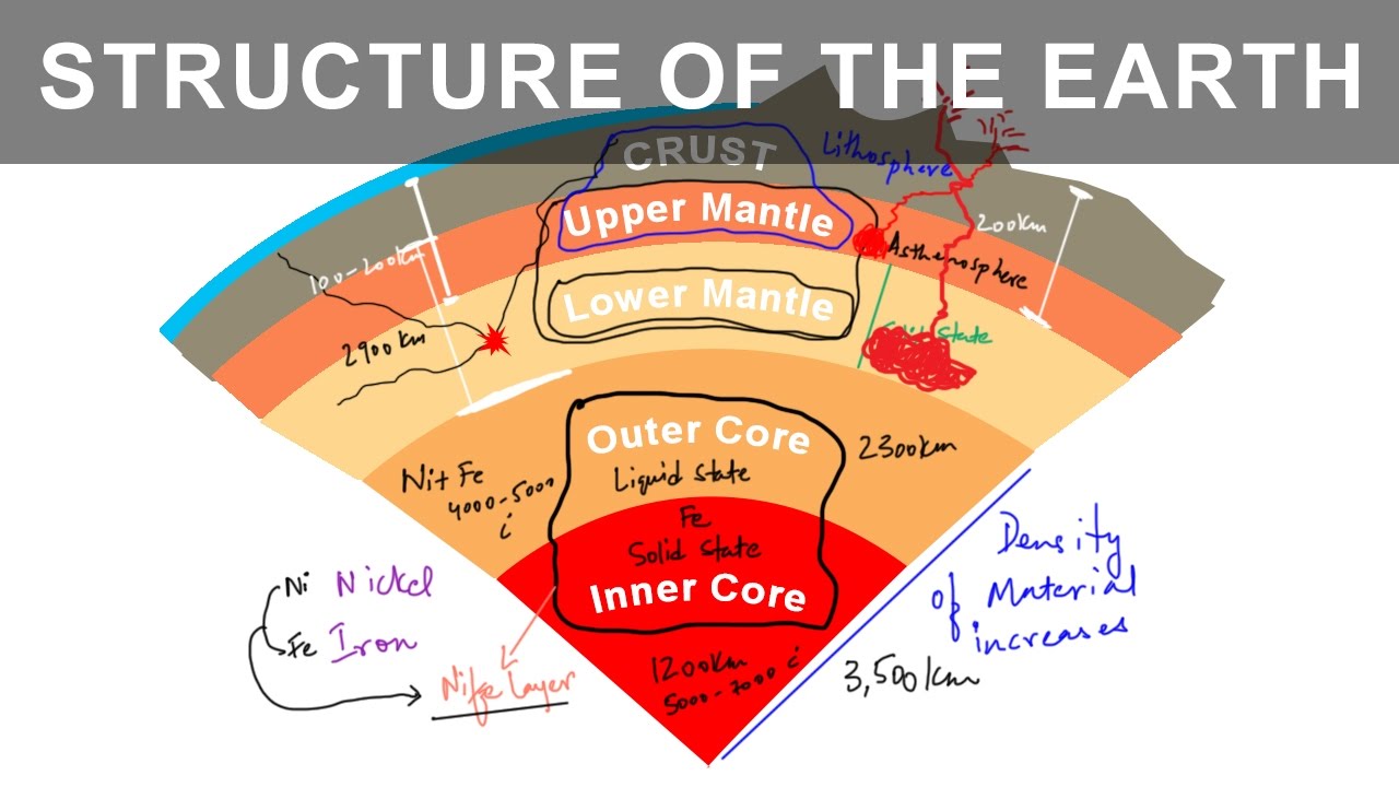
By studying how seismic waves travel, scientists found that Earth has three main concentric layers: the outer crust, the middle mantle, and the central core.

The Crust: The Brittle Outermost Layer
The crust is the thin, hard outer shell of the Earth.
- (i) Oceanic vs. Continental: The ocean floor crust (oceanic crust) is thin, about thick. Land crust (continental crust) is much thicker, averaging , and can be up to thick under high mountains like the Himalayas.
The Mantle: From Moho's Discontinuity to the Magma Source
Starting below the crust boundary (Moho's Discontinuity) down to , the mantle is the biggest middle layer of the Earth.
- (a) Upper Mantle (Asthenosphere): The soft upper part going down to is called the asthenosphere (meaning weak sphere). This runny rock zone feeds hot magma to erupting volcanoes.
- (b) Lithosphere: The hard top layer combining the entire crust and the very top solid mantle. Its thickness is between and .
- (c) Lower Mantle: The deeper mantle section below the weak asthenosphere that stays in a firm, solid state under heavy weight.
The Core: The Nickel and Iron Heart of the Planet (NIFE)
The core sits deep below at the center of the Earth and is made of heavy metal elements.
- (i) Composition: The core is mainly made of heavy elements like nickel (Ni) and iron (Fe), so geologists call it the nife layer.
- (ii) State of Matter: The outer core is hot melted liquid (blocking S-waves), while the central inner core is squeezed into a solid ball by extreme pressure.
📌 Volcanoes: Eruptive Mechanisms, Structural Types, and Intrusive Landforms
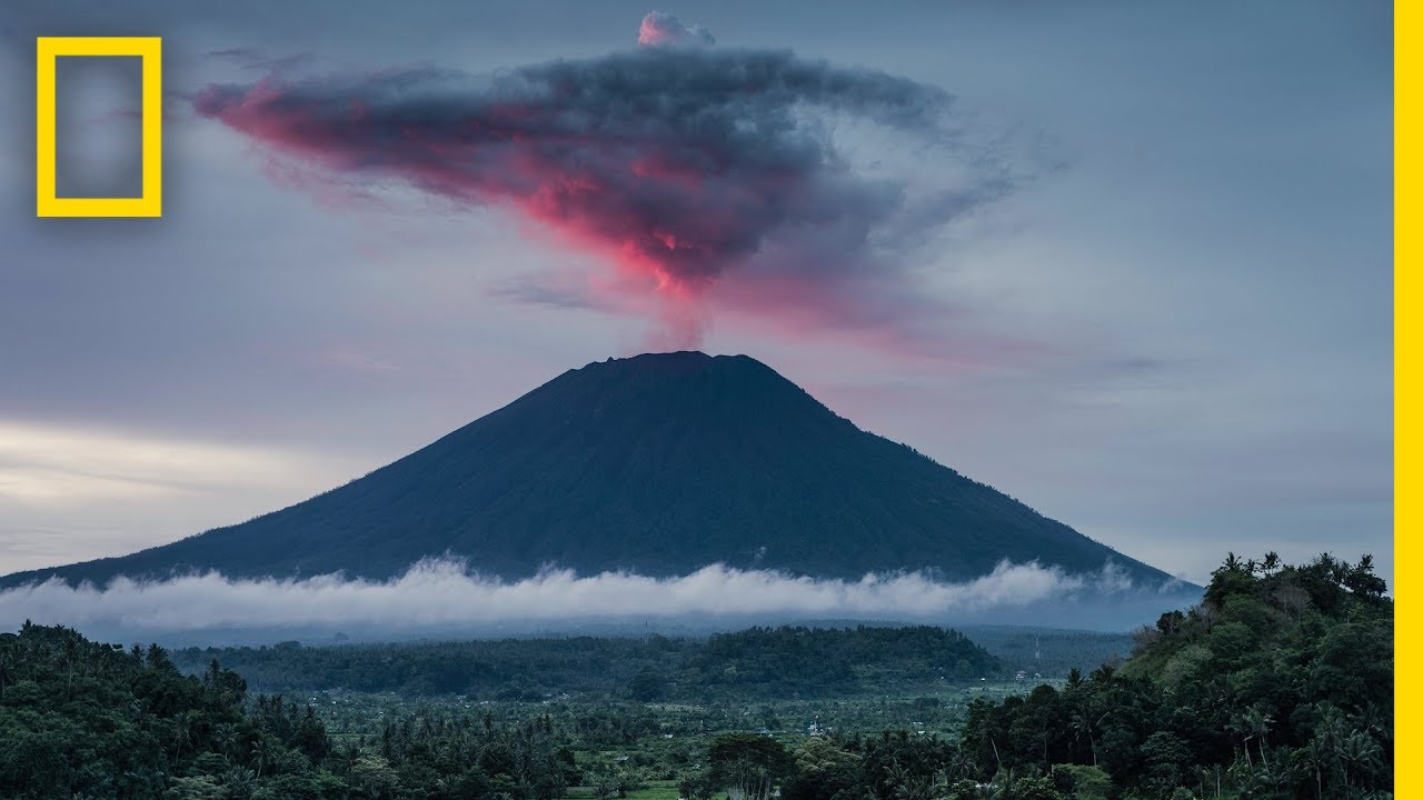
A volcano is a vent or opening in the ground where melted rock, gases, and dust shoot out from inside the Earth.
The Volcano: From Magma Source to Surface Eruption
Underground melted rock is called magma. When it comes out onto the surface, it is called lava.

Cinder cone volcano, built up by piles of ash and rock fragments around the opening. - (i) Eruptive Materials: Volcanoes blast out liquid lava, hot rock bombs, broken rock fragments (pyroclastic debris), ash, and gases like sulfur and nitrogen.
- (ii) Active Status: An active volcano is one that has erupted recently and stays connected to live liquid rock underground.
Classifying Volcanic Structures: Shield, Composite, and Explosive Types
Volcanoes come in different shapes depending on how runny or thick their lava is when it erupts.
- (a) Shield Volcanoes: The largest wide volcanoes made of runny dark lava called basalt. The lava flows far before cooling, forming a flat wide dome. The Hawaiian volcanoes are famous examples.

Shield volcano, showing a low wide dome shape from runny lava flows. - (b) Composite Volcanoes: These have thick, sticky lava and explode violently. They build steep cone mountains made of alternating layers of ash and hardened lava.

Composite volcano, showing steep cone layers made of ash and cooled lava. - (c) Caldera and Flood Basalt Provinces: A caldera is a super explosive volcano that collapses inward into a huge crater pit after erupting. Flood basalt areas, like the Deccan Traps in India, happened when vast seas of runny lava spread out across giant land areas.
- (a) Shield Volcanoes: The largest wide volcanoes made of runny dark lava called basalt. The lava flows far before cooling, forming a flat wide dome. The Hawaiian volcanoes are famous examples.
Volcanic Landforms: Extrusive and Intrusive Geological Structures
When magma cools on top of the ground, it forms extrusive landforms. When magma cools inside cracks under the ground, it hardens into intrusive igneous rocks.

Volcanic landforms, showing underground magma shapes like batholiths, sills, and dykes. - (i) Batholiths: Giant dome-shaped underground rock bodies formed when huge underground magma chambers cool down into hard granite. They only show up on top after top soil erodes away over time.
- (ii) Lacoliths, Lopoliths, and Phacoliths: Dome-shaped underground rocks with flat bottoms are called lacoliths. Saucer-shaped dips are lopoliths, and wave-shaped rock fits in folded rock layers are phacoliths.
- (iii) Sills and Dykes: Horizontal flat sheets of cooled underground rock are called sills. Vertical wall-like sheets that cut straight across rock cracks are called dykes, commonly seen in the Deccan region of Maharashtra.
📝 Summary
Learning about the Earth's interior and volcanoes gives us the main key to understanding physical geography. Earthquake waves like P-waves and S-waves help us picture the hidden crust, mantle, and core layers. Recognizing how liquid magma builds surface volcanic cones or hardens underground into shapes like dykes and batholiths makes it simple to understand how our planet continuously changes over .
🚀 Quick Revision Points
Essential facts to review before examinations:
- (i) Deepest drill hole in the world is at Kola ( depth).
- (ii) P-waves move fastest and go through solids, liquids, and gases.
- (iii) S-waves travel only through solids, creating a big liquid core shadow zone.
- (iv) The asthenosphere is the soft upper mantle layer supplying magma to volcanoes.
- 💡 Exam Tip: Remember that Richter scale measures earthquake energy (magnitude) from 0-10, while Mercalli scale measures visible damage (intensity) from I-XII.
❓ Frequently Asked Questions (FAQ)
Q1: Why can S-waves not pass through the outer core?
A1: Secondary waves (S-waves) can only move through solid rock. Because the outer core is made of liquid metal, S-waves get completely blocked, creating a large shadow zone.Q2: What is the main difference between magma and lava?
A2: Melted liquid rock beneath the surface is called magma. Once it breaks through a volcano vent and flows onto the surface, it is called lava.Q3: What is a dyke in volcanic landforms?
A3: A dyke is a vertical, wall-like underground rock formation created when magma forces its way up through vertical rock cracks and hardens beneath the surface.