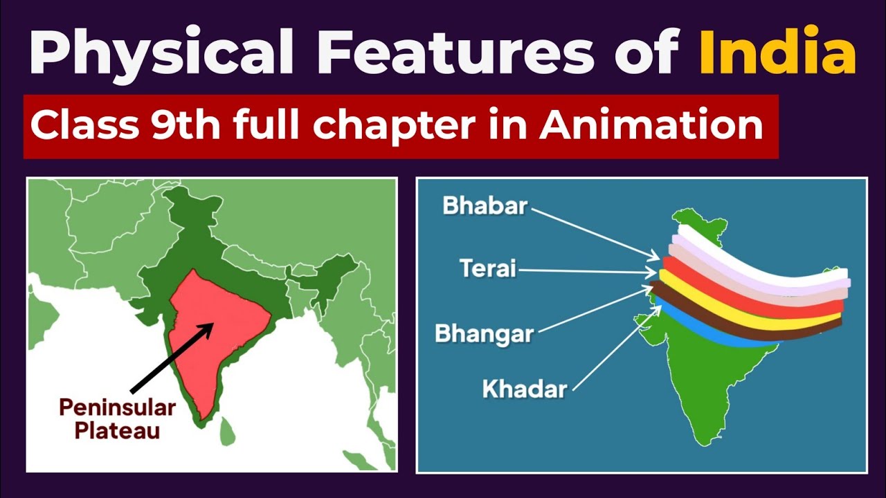
The formation of the Himalayas is a classic story of plate tectonics — the Indian Plate colliding with the Eurasian Plate, beginning about . This ongoing Indian-Eurasian collision and the successive phases of Himalayan orogenesis (from to recent times) created the Greater, Lesser and Shiwalik ranges and sculpted the Indo-Gangetic Plain, making this topic essential for students preparing for geography and geology exams.
🎯 In this chapter, you will understand:
- How the crash between the Indian Plate and the Eurasian Plate lifted huge landmasses.
- The six distinct steps in history that built these giant mountain ranges over millions of years.
- The main structural divisions, including the Tibetan Plateau, Himadri, Himachal, and Shiwalik hills.
- The major fault lines (ITSZ, MCT, MBF, HFF) and how they created fertile plains and valleys.
💡 Why this topic matters: It reveals how moving plates under Earth's surface can build the tallest peaks on Earth, control weather systems like monsoons, and build rich river valleys where millions of people live today.
🧠 Core Idea: When two giant pieces of heavy land smash into each other without sliding under, the land in between gets squished and pushed high up into the air, turning old sea floors into mountain peaks.
Formation of the Himalayas — Indian-Eurasian Plate Collision & Six Phases of Orogenesis (40–50 million years onwards)
The Himalayas were formed by the prolonged collision between the Indian Plate and the Eurasian Plate, producing uplift, folding, thrusting and a sequence of six distinct geological phases.
Let us begin by exploring how this magnificent story started and understand how every movement beneath Earth's crust helped build these vast mountain ranges.
- (i) The collision began in earnest around and continues today, raising peaks and causing frequent tremors and earthquakes.
- (ii) Because both continental plates had similar rock densities, subduction (one sinking deep under another) did not happen — instead, the rocks squished together, doubled up in thickness, and pushed high upwards.
- (iii) The result: three parallel Himalayan ranges (Greater, Lesser, Shiwalik) and associated features like the Indo-Gangetic plain and the vast Tibetan Plateau.
Formation Overview — Collision, Compression & Uplift
A brief summary: the northward movement of the Indian Plate squeezed the seabed sediments of the old Tethys Sea, folded them like cloth, and created deep cracks called thrust faults — starting a chain reaction that went on for millions of years.
Collision Impact and Mechanism
Our story starts with two giant landmasses meeting each other. Because the Indian and Eurasian plates were equally heavy, the normal rule where an ocean floor sinks below a continent did not apply here. Instead, the edges crumpled and grew very thick. The land shortened horizontally and doubled in thickness under Tibet, while mud and sand layers were squeezed up into sharp mountain peaks. This ongoing crush explains why these mountains are still growing taller every year and why seismic activity happens so often.
- (i) Both plates had similar rock density, which prevented typical subduction.
- (ii) Deep compression and pushing generated huge cracks and nappes (large stacked sheets of rock).
- (iii) The ongoing northward movement of India at about keeps pushing the peaks higher today.
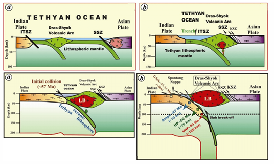
- (iv) Here is an illustration showing how ocean floors sink (subduction) and how continental crashes differ:

Diagram of standard subduction before continental collision took over.
Himalayas: Origin from the Tethys Geosyncline
Imagine an ancient ocean named the Tethys Sea sitting between two giant continents called Laurasia in the north and Gondwanaland in the south during the . Rivers dumped mountain loads of sand and mud into this sea over millions of years. When the Indian landmass drifted northward, it squeezed these ocean sediments together like an accordion, lifting them high to build the Himalayas. In fact, sea fossils and limestone from that old seabed are found today on top of the highest mountain tops!
- (i) The Tethys Sea collected thick layers of river mud and sea sand over millions of years.
- (ii) India's journey northward squished these layers, making them fold and break upward.
- (iii) Mount Everest's peak is made of ancient ocean floor limestone, proving its undersea past.

Step-by-step visual of how the ancient sea floor turned into high mountain peaks.
Tectonic Background — Plate Positions & Paleogeography
During the (), all Earth's land was joined in one giant supercontinent called Pangaea. Later, Pangaea broke into Laurasia in the north and Gondwanaland in the south. India was originally part of Gondwanaland. By the , India broke away and traveled north across the Indian Ocean, sliding over volcanic hot spots and closing the gap of the Tethys ocean in front of it.
- (i) Permian (): Pangaea existed as one big piece, then split into Laurasia and Gondwanaland.
- (ii) India split off from Gondwanaland and moved north across the Indian Ocean, squeezing the Tethys Sea in its path.
- (iii) Fast plate movement and volcanic hot spots set the stage for the building of these huge ranges.
Landform & Regional Consequences
As these tall mountains grew, they gave birth to giant rivers. These rivers rushed down, carved deep valleys, and dropped fresh mud across the flat lands south of the mountains — building the vast, fertile Indo-Gangetic Plain. The rising height of the land also lifted the huge Tibetan Plateau, changing global wind patterns and creating the famous South Asian monsoon rains that nourish the region today.
- (i) Uplift created three main parallel mountain walls: Greater, Lesser, and Shiwalik ranges.
- (ii) Mountain rivers carried soil down to construct the flat Indo-Gangetic plain.
- (iii) The rising of the high Tibetan Plateau created a massive climate wall that guides the monsoon rains.
Phases of Himalayan Formation — Six Distinct Phases
The story of these mountains happened in six major chapters or pulses. Each pulse pushed up different sections of the mountain ranges over millions of years.
Phase 1 – (Cretaceous): Initial Northward Drift and Squeezing of Tethys
In this opening chapter, India was located far down in the southern half of the globe (between ). It sped northward at a fast rate of about . This fast movement started pressing against the western edge of the Tethys Sea, beginning the very first squishing of sea sediments.
- (i) India moved quickly northward while passing over active volcanic hot spots.
- (ii) This speedy movement started shrinking the Tethys Sea and started early pressure in the crust.
Phase 2 – : Beginning of Himalayan Orogenesis & ITSZ Formation
The land crash gathered strength as the Indian Plate moved northeast and bumped into ancient rocks. This created the Indus–Tsangpo Suture Zone (ITSZ), which acts like a giant geological seam where the Indian and Asian landmasses joined together. The land under Tibet doubled in thickness, while low sinking areas called foredeeps formed to the south to catch eroded sand and mud.
- (i) Squeezing against old northern rocks started major folding of Earth's crust.
- (ii) The ITSZ seam formed as a permanent tectonic scar where the two continents locked together.
- (iii) Crustal doubling lifted the high Tibetan Plateau while deep basins opened to the south.
Phase 3 – Drass Volcanic Arc (Oligocene Period)
During the , melting crust triggered underwater volcanic eruptions inside the shrinking sea gap, creating the Drass volcanic chain. At the same time, the Indian Plate twisted slightly counter-clockwise. This twisting eased pressure in the west but squeezed the eastern sea sediments harder, raising the early Tethyan Himalayas.
- (i) Volcanic eruptions along the seafloor built up the Drass volcanic rocks.
- (ii) The slight twisting of India shifted compression forces from west to east.
- (iii) This phase marked the first clear rise of the Tethyan Himalayan belt above sea level.
Map showing the Drass Volcanic Arc during the third phase of mountain building.
Phase 4 – : Major Thrusting and Rise of the Greater Himalayas
Compression reached a powerful peak during this period. A giant subterranean crack called the Main Central Thrust (MCT) developed, snapping the crust and lifting the mighty Greater Himalayas (Himadri). This event pushed up hard granite and metamorphic rocks to form the highest mountain core in the world, changing the paths of ancient rivers.
- (i) Extreme pressure built up inside the Earth until the crust snapped along a major fault line.
- (ii) The Main Central Thrust (MCT) acted as the main elevator that lifted the Greater Himalayas.
- (iii) This rise formed the highest snow-capped peaks and redirected major river channels.
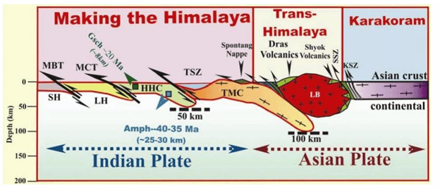
Diagram illustrating the push along the Main Central Thrust that built the Greater Himalayas.
Phase 5 – (Miocene): Rise of the Lesser Himalayas
During the , new river sediments collected in the southern basin. Fresh underground pressure squished and folded these deposits, lifting them up to form the Lesser Himalayas (Himachal Range). A second giant fault line called the Main Boundary Thrust (MBT) formed, separating these middle mountains from the high Greater Himalayas above them.
- (i) Accumulated river mud and rock layers were folded up into middle-height mountain ranges.
- (ii) The Main Boundary Thrust (MBT) formed as a clear dividing line between the high and middle ranges.
- (iii) This stage created famous hill-station ridges and complex mountain valleys.
Phase 6 – Rise of the Shiwalik Ranges (Latest Phase)
In the final chapter, young rivers flowing off the new mountains dropped huge amounts of mud, gravel, and sand at the foot of the hills. Ongoing pushing along the Himalayan Frontal Fault (HFF) crumpled these fresh river sediments into the Shiwalik Hills — the youngest, lowest, and outermost foothills of the Himalayas.
- (i) Mountain rivers dropped millions of tons of mud and gravel at the base of the range.
- (ii) Recent squeezing along the Himalayan Frontal Fault (HFF) lifted these river deposits into outer hills.
- (iii) The Shiwaliks are geologically young, fragile, and still prone to landslides and erosion today.
Phases Illustration
Here is a complete diagram showing all six phases together to help you trace how each push happened over geological time.
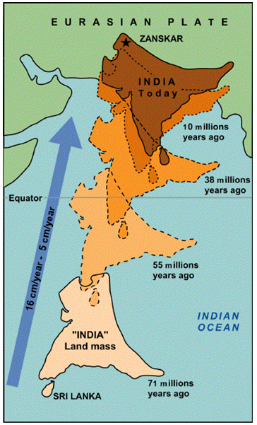
Summary map illustrating the six geological stages of Himalayan uplift.
Summary & Exam Relevance — Why This Topic Matters
The story of how the Himalayas formed links plate movements, the closing of the ancient Tethys Sea, major structural fault lines (MCT, MBT, HFF), and modern features like the fertile Indo-Gangetic Plain and monsoon weather. Keep this time progression in mind: (speeding north) → (first crash and ITSZ seam) → (raising Himadri, Himachal, and Shiwaliks step-by-step). Because the Indian landmass is still creeping north at about , the story remains active today!
The Himalayan Mountain System represents one of the most remarkable results of plate tectonic activity, where the Indian Plate collided with the Eurasian Plate. This complex geological evolution has given rise to a diverse series of ranges — from the lofty Tibetan Plateau to the fertile Indo-Gangetic Basin. Understanding their formation, structure, and significance is crucial for geography students and competitive exam preparation.
Formation and Structure of the Himalayan Ranges: A Geological Overview
Let us now explore each structural division of the Himalayas from north to south, examining their unique rocks, heights, and special features.
The Tibetan Plateau: The Elevated Hinterland
The story of the Tibetan Plateau begins with the huge underground pressure created during the mountain-building crash. Even though it sits behind the main Himalayan wall, this elevated plateau is deeply connected to the regional geology and weather.
- (i) It is famous worldwide as the “Roof of the World” because of its vast size and extreme height.
- (ii) Formed when the land doubled in thickness during the plate crash, it helps guide monsoon winds across Asia.
- (iii) Its high frozen surface blocks freezing arctic winds from blowing south into India, keeping South Asia warmer.
Indus–Tsangpo Suture Zone (ITSZ): The Line of Collision
The Indus–Tsangpo Suture Zone is the exact collision seam where the Indian Plate locked onto the Eurasian Plate.
Geological Characteristics of the ITSZ
This long crack stretches nearly from the Indus Gorge in the west to the Tsangpo Gorge in the east, marking the main tectonic joint between continents.
- (i) The rocks along this boundary are crushed and pulverized from extreme sideways pressure.
- (ii) It contains ancient ocean floor rocks from the alongside deeply altered metamorphic layers.
- (iii) Major rivers like the Indus and Tsangpo (Brahmaputra) flow right along this crack, carving deep valleys.
Tethyan Himalayas: The First Uplift
The Tethyan Himalayas represent the very first slice of ancient sea floor raised up from the Tethyan Geosyncline.
Formation and Composition
This range sits at an average elevation of about and lies pressed directly against the Greater Himalayas without any big valley dividing them.
- (i) It is made mainly of submarine sedimentary rocks and squeezed metamorphic rocks full of marine fossils.
- (ii) It displays intense folding caused by early sideways squishing.
- (iii) It marks the earliest mountain land raised out of the ancient sea.
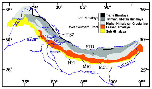
Diagram showcasing the elevated Tethyan Himalayan zone.
Greater Himalayas: The Lofty Backbone
The Greater Himalayas, also known as the Himadri Range, form the highest, snowiest, and most majestic central core of the entire mountain wall.
Key Structural and Physical Features
Stretching continuously for over from Nanga Parbat in the west to Namcha Barwa in the east, this range holds the tallest mountain peaks on Earth.
- (i) The average elevation exceeds 6000 m, with many famous peaks soaring past 7000 m and 8000 m.
- (ii) It features deep gorges, steep cliff faces, and smooth, symmetrical curves on both sides.
- (iii) It contains a strong granitic core (batholith) wrapped in tough metamorphic and sedimentary rock layers.

Visual landscape view of the snow-bound Greater Himalayas (Himadri).
Main Central Thrust (MCT): The Tectonic Divide
The Main Central Thrust is an important fault line that marks the boundary between the Greater Himalayas and the Lesser Himalayas.
Characteristics and Valleys of MCT
Along this massive fault line, deep rocks were thrust upward over surface layers, creating scenic valleys and cracked geological terrain.
- (i) It forms a major compression valley zone filled with crushed and sheared rock layers.
- (ii) Famous valleys like Kathmandu, Kashmir, Kulu, and Kangra sit near this structural boundary.
- (iii) Some valleys cut across the range (like Kulu), while others run parallel (like Kangra); active fault movements make them prone to earthquakes.

Tectonic map depicting major fault boundaries: MCT, MBT, and HFF.
Lesser Himalayas: The Middle Range
The Lesser Himalayas, or Himachal Range, act as a middle step between the tall snow peaks of Himadri and the lower outer hills.
Physical and Structural Characteristics
Running for about with an average height of around , this range features folded rocks and forest-covered ridges.
- (i) It runs parallel to the Greater Himalayas on their southern side.
- (ii) It includes famous parallel ridges like Pir Panjal and Dhaula Dhar, as well as cross-ranges like Mussoorie and Nagtiba.
- (iii) It is called the Mahabharata Range in Nepal and continues as the Dafla, Miri, Abor, and Mishmi Hills in eastern India.

Map of the Lesser Himalayan belt showing major mountain ranges. 
Overview diagram displaying all three main parallel belts.
Main Boundary Fault (MBF): The Zone of Transition
The Main Boundary Fault (or Main Boundary Thrust) forms the border between the Lesser Himalayas and the outer Shiwalik Hills.
Features and Doons
Although not as deep as the MCT, the MBF contains broad flat-bottomed valleys filled with ancient lake sediments called lacustrine deposits.
- (i) Famous examples of these flat valleys include Dehra Dun, Patli Dun, and Kotli Dun.
- (ii) These flat valleys are called Doons in the western and central Himalayas and Duars in the eastern region.
- (iii) Geologically, they are classified as wide-angle reverse thrust faults caused by sideways compression.
Shiwaliks: The Outer Foothills
The Shiwalik Range forms the southernmost outer boundary of the Himalayas and is built almost entirely of river mud and sand deposits.
Formation and Characteristics
Standing at a modest height between , the Shiwaliks were built from river-borne sand and gravel that accumulated in the southern basin before being crumpled upward.
- (i) They are famous for hogback topography (steep narrow ridges) and end abruptly where the flat plains begin.
- (ii) They are known locally as the Churia Hills in Nepal and the Dafla-Miri-Abor Hills in Assam.
- (iii) These outer hills gradually disappear near where the Ganges River enters the plains.
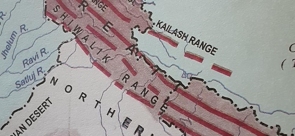
Landscape photograph showing the low outer Shiwalik foothills.
Himalayan Frontal Fault (HFF): The Final Compression Line
The Himalayan Frontal Fault marks the outer structural boundary where the mountain foothills meet the flat Gangetic Basin.
Features and Significance
This wide-angle fault line represents the most recent boundary line created by mountain-building forces.
- (i) It forms the southernmost line where Himalayan rock structures end and flat river plains begin.
- (ii) It plays an active role in forming river step terraces and land features right along the edge of the plains.
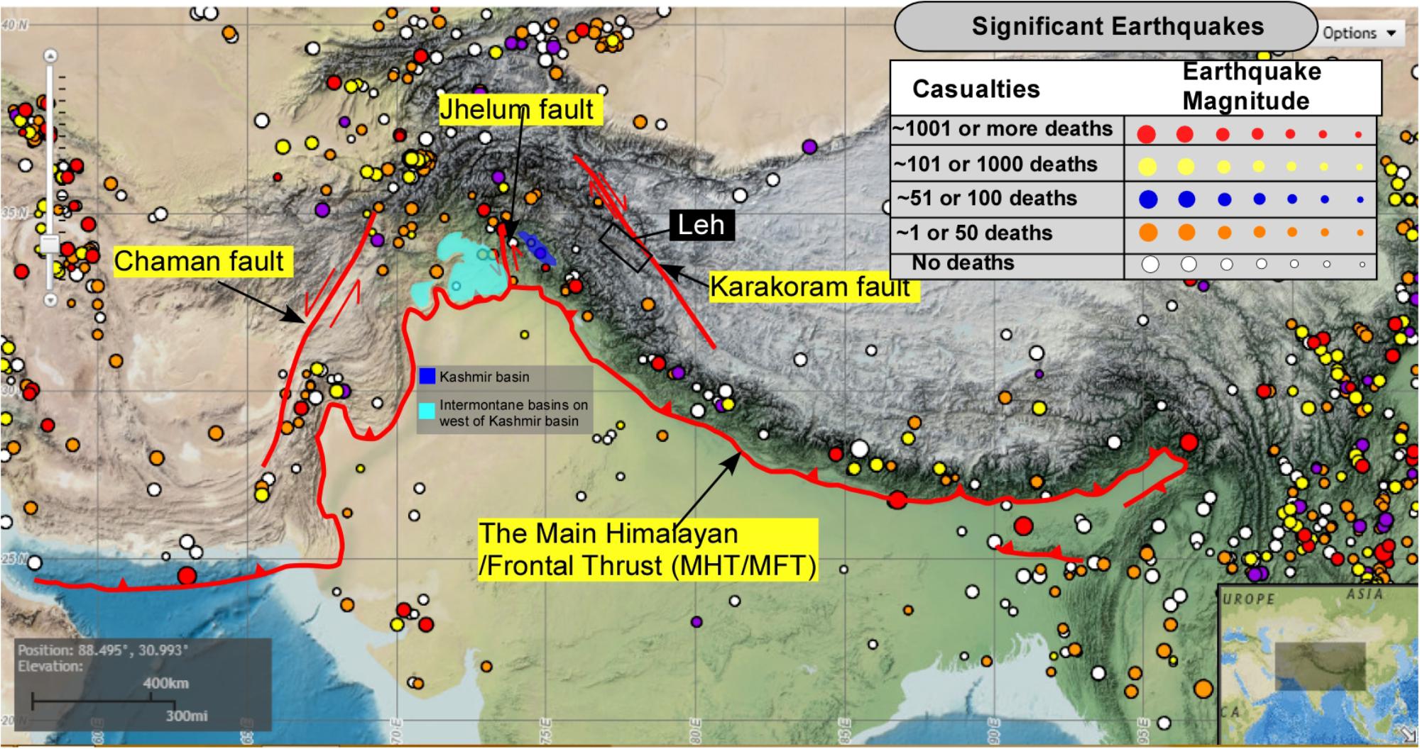
Cross-section of the Himalayan Frontal Fault at the plains edge.
Indo-Gangetic Basin: The Himalayan Foredeep
The Indo-Gangetic Basin is a broad, fertile river plain built at the foot of the mountains through millions of years of river deposit dumping.
Formation and Importance
This broad lowland sits sandwiched between the Himalayas in the north and the ancient Peninsular Plateau in the south, forming India's most fertile farming land.
- (i) It was built up by deep layers of mud dropped by the Indus, Ganga, and Brahmaputra river systems.
- (ii) It is packed with rich alluvial soils that nourish intensive farming and support hundreds of millions of people.
- (iii) It has served as the cradle for ancient civilizations and cultural growth in South Asia across history.
Summary: Geological Evolution and Student Significance
The entire Himalayan Mountain System — from the elevated Tibetan Plateau down to the flat Indo-Gangetic Basin — provides a living demonstration of plate tectonics and Earth's dynamic crust. Understanding how each zone formed gives students a clear, connected picture for geography, geology, and environmental science studies.
⚡ Quick Revision Capsule: Himalayan Zones & Thrusts
Use this summary table to quickly revise the main zones, fault lines, rock types, and key features of the Himalayas before exams:
| Himalayan Zone / Boundary | Geological / Fault Marker | Key Features & Rock Types |
|---|---|---|
| Tibetan Plateau | Hinterland Zone | Known as "Roof of the World"; lifts atmospheric winds and impacts weather. |
| ITSZ (Indus-Tsangpo Suture) | Plate Collision Seam | Suture seam with crushed Paleozoic and ocean rocks where continents joined. |
| Tethyan Himalayas | First Uplift Zone | Contains marine fossil limestone and sedimentary rocks from the old sea floor. |
| Greater Himalayas (Himadri) | Main Central Thrust (MCT) | Tallest peaks (>6000 m average); granite core with tough metamorphic rocks. |
| Lesser Himalayas (Himachal) | Main Boundary Fault (MBF) | Middle mountains (Pir Panjal, Dhaula Dhar); separated from Shiwaliks by MBF. |
| Shiwalik Hills | Himalayan Frontal Fault (HFF) | Youngest foothills (800–1200 m); made of loose river mud and gravel deposits. |
| Indo-Gangetic Basin | Foredeep Alluvial Plain | Fertile river basin created by alluvium from the Indus, Ganga, and Brahmaputra. |
📝 Summary
The Himalayas were formed through a continuous continental crash between the Indian Plate and the Eurasian Plate that started around . Squeezing the old seabed of the Tethys Sea across , this process created four distinct belts (Tethyan, Greater, Lesser, and Shiwalik) separated by giant structural fault lines (ITSZ, MCT, MBF, HFF) and built the fertile Indo-Gangetic Plain at its base.
🚀 Quick Revision Points
Essential facts to review before examinations:
- (i) The Indian Plate collided with Eurasia around , closing the ancient Tethys Sea.
- (ii) Because both plates had similar continental density, land folded upward instead of sinking into a subduction trench.
- (iii) The four major fault lines from north to south are ITSZ, MCT, MBT, and HFF.
- (iv) Flat-bottomed valleys created along the Main Boundary Fault are called Doons (e.g., Dehra Dun) in the west and Duars in the east.
- 💡 Exam Tip: When drawing diagrams in exams, label the structural zones from north to south in correct sequence: Tibetan Plateau → ITSZ → Tethyan Himalayas → MCT → Greater Himalayas → MBT → Lesser Himalayas → HFF → Shiwaliks → Indo-Gangetic Plain.
❓ Frequently Asked Questions (FAQ)
Q1: Why do marine fossils exist on top of Mount Everest?
A1: Because the rocks forming the summit of Everest were originally sediment layers deposited on the floor of the ancient Tethys Sea before being squeezed and pushed high into the sky during continental collision.Q2: What is the Main Central Thrust (MCT)?
A2: The Main Central Thrust is a major subterranean fault line that cracked Earth's crust during Phase 4 of mountain building, lifting up the granite-rich Greater Himalayas.Q3: What are "Doons" and how did they form?
A3: Doons (like Dehra Dun) are flat longitudinal valleys that formed along the Main Boundary Fault between the Lesser Himalayas and the Shiwalik Hills, where temporary lakes collected river mud and gravel.