The Peninsular Plateau of India is an ancient, raised landform that contains many smaller elevated landforms called plateaus along with flat plains. Regions like the Chotanagpur Plateau and the massive Deccan Plateau show how nature shaped India over millions of years through volcanoes, river erosion, and movements of the earth's crust.
🎯 In this chapter, you will understand:
- How central plateaus like Baghelkhand and Rohtas divide river waters and shape the land.
- Why the Chotanagpur Plateau is rich in rocks like basalt and valuable mineral resources like coal.
- The structure of the huge Deccan Plateau, including its lava-made step-like landforms known as Deccan Traps.
- The unique geographical and historical features of regions like Bastar, Chhattisgarh Plain, and Dandakaranya.
💡 Why this topic matters: India's plateaus hold crucial natural resources such as coal, rich black soil for farming, and major river systems that support millions of people.
🧠 Core Idea: Elevated, flat-topped tablelands across India have distinct rock types, river pathways, and heights that divide different geographic zones.
Baghelkhand Plateau
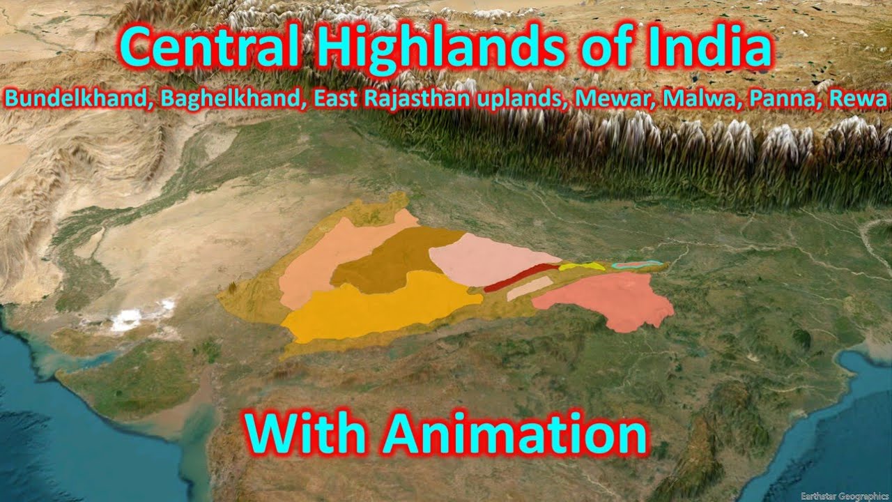
The Baghelkhand Plateau is a key central landform located north of the Maikal Range.
Location and Composition
This plateau features varied rocks and acts as an important water divider between major northern and southern river basins.
- (i) It sits directly north of the Maikal Range and is bounded by the Son River on its northern side.
- (ii) On the western side, it is made of limestone and sandstone, while its eastern side consists mostly of granite.
Baghelkhand Landscape Details
The middle portion of this region splits river drainage paths across the landscape.
- (a) The central part serves as a natural water divide separating the Son river system in the north from the Mahanadi river system in the south.
- (b) The land is uneven, with general heights ranging from to above sea level.
- (c) Prominent structures like Bharner and Kaimur sit close to the main trough axis.
- (d) The flat layers of rock, or horizontal strata, show that the ground has stayed mostly calm without major earth movements over time.

Rohtas Plateau
The Rohtas Plateau is an elevated tableland that forms an important section of eastern central India.
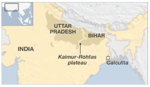
- Also known locally as the Kaimur Plateau, this region lies in the south-western part of the state of Bihar.
- It spans around 800 square miles (2,100 km²) and forms an uneven, rolling tableland. At Rohtasgarh, it reaches a height of () above sea level.
Surrounding Geography
This area forms the eastern end of a continuous chain of step-down plateaus along the Kaimur Range.
- (i) The Panna Plateau starts on the far western end of this chain.
- (ii) The land steps down to the Bhander Plateau next.
- (iii) It continues into the Rewa Plateau.
- (iv) The sequence ends with the Rohtas Plateau in the east.
Bhander Plateau
The Bhander Plateau is an important connective landscape lying inside the state of Madhya Pradesh.
- It covers a large area of 10,000 square kilometers within central India.
Bhander Geographical Links
This region links three major geographical divisions of the Indian subcontinent together.
- (i) It sits as a structural part of the Vindhya Range.
- (ii) It joins the Deccan Plateau to the south with the northern Indo-Gangetic Plains and the eastern Chota Nagpur Plateau.
- (iii) It forms part of the descending Kaimur chain between the western Panna Plateau and the eastern Rohtas Plateau.
Chotanagpur Plateau
The Chotanagpur Plateau forms the north-eastern extension of the main Peninsular landmass of India.
- It lies mostly within Jharkhand, as well as northern Chhattisgarh and the Purulia district of West Bengal.
Major Rivers and Regions
A network of rivers flows outwards from this central region in all directions, creating a distinct pattern.
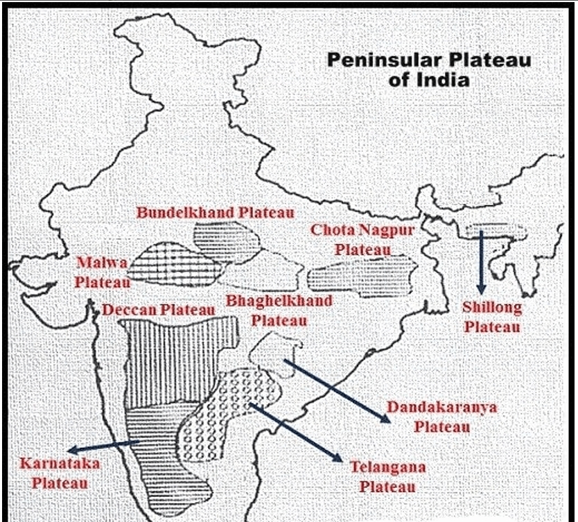
Chotanagpur Plateau image in map - Average Elevation: Reaches an average height of above sea level and is made mainly of ancient Gondwana rocks.
- Drainage Pattern: Multiple streams spread outward in a radial drainage pattern. Key rivers include the Damodar, Subarnarekha, North Koel, South Koel, and Barakar.
- Damodar Valley Coal Fields: The Damodar River flows eastwards through a deep rift valley in the center of the plateau, holding rich Gondwana coal deposits that produce much of India's coal.
- Hazaribagh, Ranchi, and Rajmahal: North of the river sits the Hazaribagh Plateau (), featuring worn-down plains (peneplain) and isolated hills. To the south lies the rolling Ranchi Plateau (), interrupted by hard rock mounds called monadnocks. The eastern border features the basalt lava-covered Rajmahal Hills ( average height).
Meghalaya Plateau
The Meghalaya Plateau, also known as the Shillong Plateau, is an eastern detached outpost of the main Peninsular Plateau.
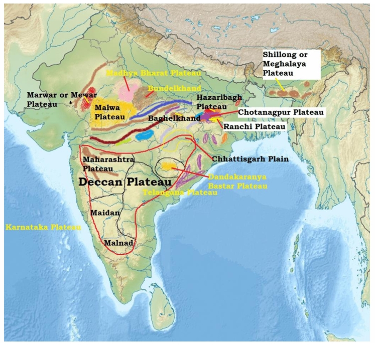
- This land stretches east beyond the Rajmahal Hills but is separated from the main block by the Garo-Rajmahal Gap (or Malda Gap), created when land sank downwards (down-faulting) and was later filled by river silt from the Ganga and Brahmaputra.
Major Regions
Made of ancient rocks like quartzite, shale, and schist, it slopes toward the Brahmaputra Valley in the north and the Surma-Meghna Valleys in the south.
- (i) The western portion is known as the Garo Hills ().
- (ii) The central and eastern parts comprise the Khasi-Jaintia Hills ().
- (iii) The Mikir Hills () form the easternmost extension.
- (iv) The highest peak on the plateau is Shillong Peak, standing at above sea level.
Deccan Plateau
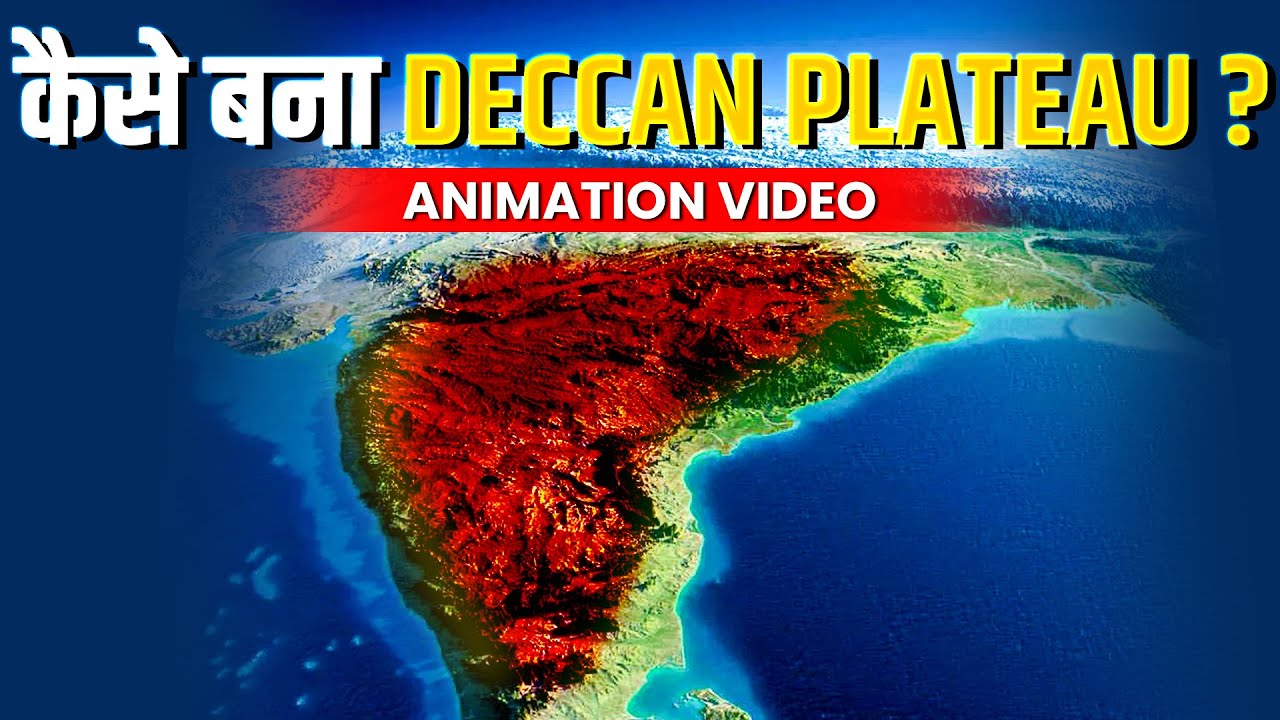
The Deccan Plateau is a massive triangular landmass covering nearly five lakh square kilometers (500,000 sq km) of central and southern India.
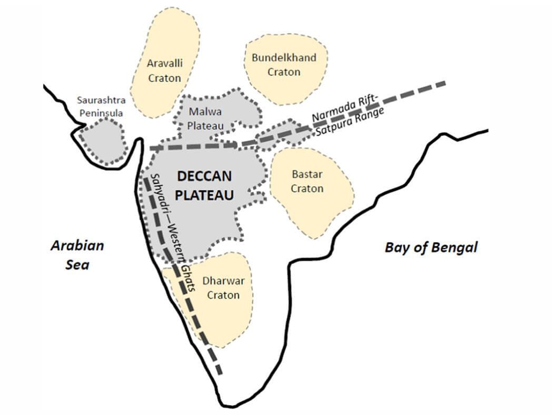
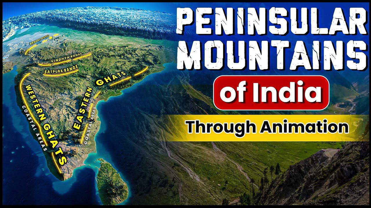
- It is bounded by the Satpura and Vindhya ranges in the north-west, the Mahadev and Maikal ranges in the north, the Western Ghats in the west, and the Eastern Ghats in the east.
- It has an average elevation of , rising to in the south and gently dipping down to in the north.
- The general slope tilts from west to east, as shown by the flow of its major eastward-flowing rivers.
Maharashtra Plateau
The Maharashtra Plateau forms the northern, lava-covered portion of the larger Deccan Plateau.
Geography of Maharashtra Plateau
The underlying rocks here come directly from ancient volcanic activity.
- (i) The entire region rests on volcanic basalt rocks formed by cooled lava, known as the Deccan Traps.
- (ii) Natural breaking down of rocks (weathering) has given the land a gently rolling appearance with step-like hills.
- (iii) The wide, shallow river valleys of the Godavari, Bhima, and Krishna are bordered by steep, flat-topped ridges.
- (iv) The land is coated in fertile black soil called regur, which is excellent for growing cotton.
Karnataka Plateau
Also called the Mysore Plateau, this region lies directly south of the Maharashtra Plateau with an average height of to .

Plateau Division
The land is carved up by rivers flowing from the Western Ghats and is split into two distinct geographic zones.
- (i) Malnad: Meaning "hill country" in Kannada, this section features deep forested valleys and rugged terrain.
- (ii) Maidan: A rolling plain with low, smooth granite hills.
- (iii) The highest mountain peak in this plateau is Mulangiri () located in the Baba Budan Hills of the Chikmagalur district.
- (iv) In the far south, the plateau narrows between the Western and Eastern Ghats to meet the Nilgiri Hills.
Telangana Plateau
The Telangana Plateau consists of ancient rock formations with an average height of to .
- It is made up of ancient gneiss and Dharwar rock layers, along with coal-bearing Gondwana rocks inside the Godavari Valley.
- Due to its Dharwar rock strata, the region is highly rich in valuable mineral reserves.
- The southern part is elevated higher than the northern part, and the area is drained by the Godavari, Krishna, and Penner river systems.
- The land surface is divided between higher hill ranges (Ghats) and flat, eroded land surfaces (peneplains).
Bastar Plateau
The Bastar Plateau lies in the southernmost part of Chhattisgarh state between the Mahanadi and Godavari rivers.
- This forest-rich and mineral-rich elevated region is bisected into two parts by the Indravati River.
- It is home to diverse indigenous tribal communities and has faced political instability due to Naxalite movements.
Chhattisgarh Plain
The Chhattisgarh Plain is a unique landform, being the only notable low-lying plain located inside the Peninsular Plateau.
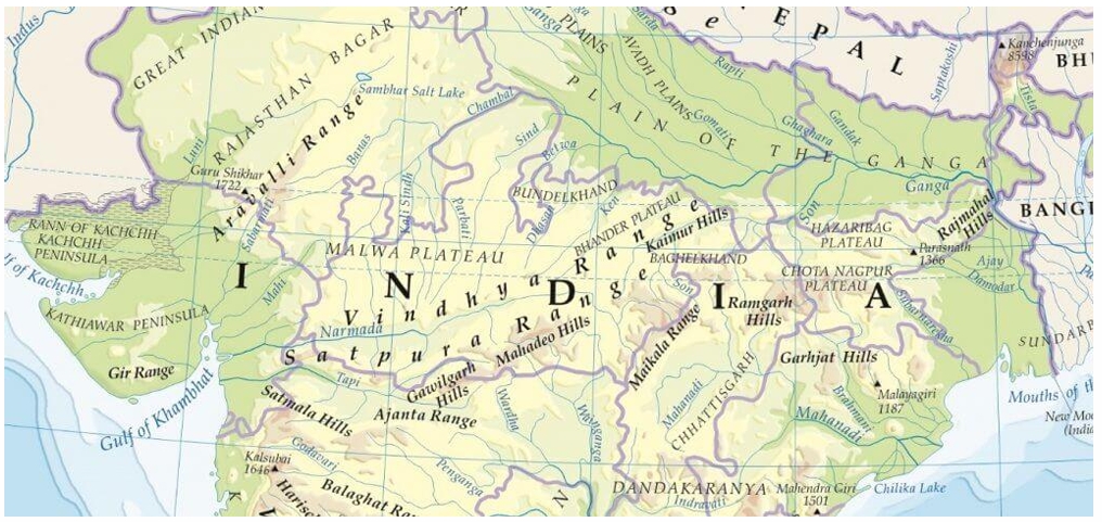
- It forms a bowl-like depression drained by the upper stretches of the Mahanadi River between the Maikal Range and Odisha hills.
- Named after the thirty-six (chhattisgarh) historic forts left behind by the ruling Haihaivanshi Rajputs.
- It is underlain by flat layers of limestone and shale, with elevation rising from in the east to in the west.
Dandakaranya Plateau
Dandakaranya is an ancient historical and geographical region spanning about 35,600 square miles across central-eastern India.
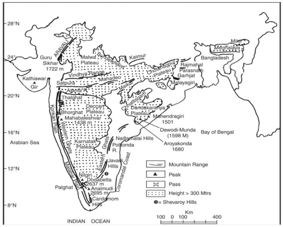
- Famous from the epic Ramayana, this region covers parts of Chhattisgarh, Odisha, Telangana, and Andhra Pradesh.
- It stretches roughly from north to south and from east to west, bounded by the Abujhmad Hills in the west and Eastern Ghats in the east.
- The dense forest zone of Abujmarh (across Narayanpur, Bijapur, and Dantewada districts) is inhabited by indigenous tribes including the Gond, Muria, Abuj Maria, and Halba.
⚡ Quick Revision Capsule: Indian Plateaus Comparison
A quick summary comparing the main features, rock types, and key heights of peninsular landforms.
| Plateau Region | Dominant Rock Types / Features | Key Heights / Location |
|---|---|---|
| Baghelkhand | Limestone, sandstone, and granite | to ; North of Maikal Range |
| Chotanagpur | Gondwana coal rocks, basalt lava in Rajmahal | Average ; Jharkhand & West Bengal |
| Meghalaya | Quartzite, shale, schist | Shillong Peak at ; North-East India |
| Maharashtra | Basaltic lava sheets (Deccan Traps) | Step-like terrain; Black regur soil |
| Karnataka | Granite hills and forested valleys | Mulangiri Peak at ; Malnad & Maidan |
📝 Summary
The Peninsular Plateau of India is composed of ancient rock formations created over . From the coal-producing rift valleys of the Chotanagpur Plateau to the lava-formed steps of the Deccan Traps, these elevated lands define India's geography, divide major river systems, and store invaluable mineral riches celebrated in historical texts like the Ramayana.
🚀 Quick Revision Points
Essential facts to review before examinations:
- (i) The Baghelkhand Plateau divides water between the Son and Mahanadi river systems.
- (ii) Chotanagpur Plateau features a radial drainage pattern and holds important Gondwana coal beds in the Damodar Valley.
- (iii) The Garo-Rajmahal (Malda) Gap separates the Meghalaya Plateau from the main Peninsular mass.
- (iv) Maharashtra Plateau is made of basalt lava layers forming Deccan Traps covered in black cotton soil.
- 💡 Exam Tip: Remember that Malnad refers to the hilly, forested region while Maidan refers to the open rolling plain in the Karnataka Plateau!
❓ Frequently Asked Questions (FAQ)
Q1: What are the Deccan Traps?
A1: They are step-like mountain features formed by multiple layers of cooled volcanic lava (basalt) across the Maharashtra Plateau.Q2: How was the Meghalaya Plateau separated from the main Indian Peninsula?
A2: It was separated by ground sinking down (down-faulting) to form the Malda Gap, which was later filled with river mud brought by the Ganga and Brahmaputra.Q3: Which historic text mentions the Dandakaranya region?
A3: The ancient epic Ramayana mentions Dandakaranya as a vast forest region.