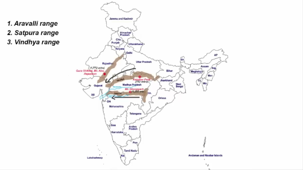
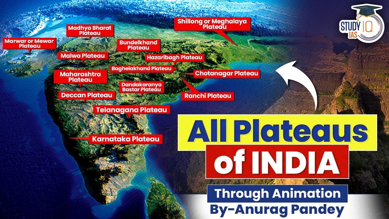
The Minor Plateaus located within the larger Peninsular Plateau of India are made up of smaller regional highlands. Each plateau has its own special rocks, ground height, and river patterns that have developed over a very long .
🎯 In this chapter, you will understand:
- The location and rock structure of the Marwar and Central Highlands.
- How rivers shape the rough landscapes of Bundelkhand and Malwa.
- The key geographical features of Baghelkhand, Rohtas, and Bhander plateaus.
- How soil types and land shapes affect farming, economics, and river flow.
💡 Why this topic matters: Understanding these smaller plateaus helps us learn how land shape, soil quality, and river networks influence farming, economic growth, and natural water flow across central India.
🧠 Core Idea: Peninsular India is divided into several unique highland areas that act as natural bridges between mountains, plains, and river valleys.
Marwar Plateau (Mewar Plateau)
The Marwar Plateau, also called the Mewar Plateau, sits in eastern Rajasthan just to the west of the famous Aravali Range. It has an elevation of above sea level and gently slopes down toward the east. The rocks underneath are made of ancient Vindhyan-period sandstone, shales, and limestone.
Central Highland (Madhya Bharat Pathar)
To the east of the Marwar Upland lies the Central Highland, also known as the Madhya Bharat Pathar or Madhya Bharat Plateau.
- (i) The landscape is defined by the Banas River and its smaller feeder streams, the Berach River and Khari River, which start in the Aravalis and wear down the land into rolling plains.
- (ii) This region features the Chambal River basin flowing through a sunken valley called a rift valley.
Bundelkhand Upland Features
The region is supported by main tributary streams including the Kali Sindh River, Banas River, Parwan River, and Parbati River.
- (a) The terrain has thick forests and gently rounded sandstone hills.
- (b) It contains large networks of deep cut valleys called ravines or badlands located north of the Chambal River.
- (c) Further east and south sits the Bundelkhand Upland, a very old, deeply worn plateau defined by its signature Bundelkhand gneiss alongside rich deposits of granite.
- (d) It is bordered by the Yamuna River to the north, the Madhya Bharat Pathar to the west, the Vindhyan Scarplands to the east and south-east, and the Malwa Plateau to the south, spreading across of Uttar Pradesh and of Madhya Pradesh.
Malwa Plateau
The Malwa Plateau is a roughly three-sided landmass sitting on the Vindhyan Hills and tightly surrounded by the Aravali Range, Madhya Bharat Pathar, and Bundelkhand. It slopes northward, dropping from in the south to below in the north.

- The Bundelkhand Upland has an elevation profile of that slopes down toward the Yamuna River.
Baghelkhand and Surrounding Regions
Centuries of continuous wearing down by the Betwa River, Dhasan River, and Ken River have carved an uneven, old land surface that makes farming very difficult in Bundelkhand.
- (i) The Malwa Plateau is covered in rich black soil created by ancient, spread-out lava flows.
- (ii) Water from this plateau drains into rivers traveling toward both the Arabian Sea and the Bay of Bengal.
- (iii) The northern edges of the Malwa Plateau are deeply cut by the well-known Chambal ravines.
- (iv) Moving east, Baghelkhand sits directly north of the Maikal Range, showing a mix of limestones and sandstones in its western half and granite in the east.
Rohtas and Bhander Plateaus
Baghelkhand is bounded by the Son River to the north, which acts as a major natural water wall separating the northern Son river network from the southern Mahanadi River network. Heights here vary between , with the prominent Bharner Hills and Kaimur Hills located near its central dip.
- The flat rock layers of Baghelkhand show that the land has stayed stable without major earthquakes over a very long time.
Value-Add Geographic Insights
In southwestern Bihar lies the Rohtas Plateau (also called the Kaimur Plateau), covering a flat elevated area of about and reaching a peak height of at Rohtasgarh.
The Water Divide and Drainage Network of Central India - Soil and Economic Divide: Differences in soil create distinct economic zones. The rich volcanic black soil (also called Regur soil) of the Malwa Plateau makes it ideal for growing cotton and oilseed crops.
- Eroded Badlands Impact: In contrast, the heavily cut badland area of the Bundelkhand Upland and Chambal Basin limits farming, creating hard-to-reach areas that affected local development.
- Vindhyan Watershed Divide: The line formed by the Bhander, Baghelkhand, and Rohtas plateaux creates India's central watershed divide.
- River Flow Path: This high ridge stops major rivers from the south from flowing directly north into the Indo-Gangetic plains, forcing rivers like the Narmada River and Tapi River west to the Arabian Sea while sending others northeast into the Ganges River system.
⚡ Quick Revision Capsule: Minor Plateaus Overview
A quick comparison of the major geographic features, elevations, and rivers across the minor plateaus of India.
| Plateau Region | Elevation & Geology | Key Rivers & Soil Features |
|---|---|---|
| Marwar Plateau | ; Sandstone, shale, and limestone | Banas, Berach, and Khari rivers |
| Central Highland | Rolling plateau with rounded sandstone hills | Chambal river basin with deep ravines |
| Bundelkhand Upland | ; Granite and Bundelkhand gneiss | Betwa, Dhasan, and Ken rivers; eroded land |
| Malwa Plateau | Slopes north from to below | Fertile volcanic Regur soil; Chambal tributaries |
| Baghelkhand & Rohtas | Heights from ; Sandstone, limestone, granite | Son and Mahanadi rivers divide; Kaimur Range steps |
📝 Summary
The minor plateaux of Peninsular India form a complex network of tablelands, highlands, and river basins. Over millions of , river action and ancient volcanic activity have shaped distinct soil profiles and land structures, creating unique natural boundaries between northern and southern India.
🚀 Quick Revision Points
Essential facts to review before examinations:
- (i) The Marwar Plateau sits west of the Aravali Range and features sandstone and limestone.
- (ii) The Chambal River basin is famous for creating deep ravine networks and badland terrain.
- (iii) The Malwa Plateau contains volcanic black soil highly suitable for cotton farming.
- (iv) The Bhander Plateau covers in the Vindhya Range and acts as a bridge to the Chotanagpur Plateau.
- 💡 Exam Tip: Remember that the Son River acts as a structural water divide separating the northern Ganges/Son drainage from the southern Mahanadi system!
❓ Frequently Asked Questions (FAQ)
Q1: What is the main rock type found in the Bundelkhand Upland?
A1: Bundelkhand is characterized by its signature Bundelkhand gneiss along with large deposits of granite rock.Q2: Why is the Malwa Plateau important for agriculture?
A2: The Malwa Plateau is covered in fertile volcanic Regur soil (black soil), which holds moisture well and is excellent for growing cotton and oilseeds.Q3: How does the central watershed divide affect river flow in India?
A3: Formed along the Bhander, Baghelkhand, and Rohtas steps, this ridge blocks central rivers from going north, directing rivers like the Narmada River west to the sea and others toward the Ganges system.