
The formation of the Himalayas is a classic story of plate tectonics, where giant pieces of Earth's crust move and bump into each other. It began when the Indian Plate crashed into the Eurasian Plate starting about . This ongoing Indian-Eurasian collision and the steps of phases of Himalayan orogenesis (which means mountain building, from up to recent times) squeezed the land to make the Greater, Lesser and Shiwalik ranges and shaped the fertile Indo-Gangetic Plain, making this an essential subject for students preparing for geography and geology exams.
🎯 In this chapter, you will understand:
- How two giant pieces of Earth's crust crashed and squeezed together to lift up massive mountain ranges.
- How an ancient, deep sea named the Tethys Sea slowly disappeared and turned into high mountain peaks.
- The step-by-step story of six different time periods (orogenic phases) that built these mountains.
- How these rising mountains created rivers, formed giant flat plains, and changed the weather system.
💡 Why this topic matters: It explains why huge earthquakes happen in Asia, how major rivers like the Ganga were born, and how the highest mountains on Earth keep growing taller today.
🧠 Core Idea: When two heavy landmasses smash together, neither can sink underneath the other, so the land buckles, folds, and pushes upward into giant mountain ridges.
📌 Formation of the Himalayas — Indian-Eurasian Plate Collision & Six Phases of Orogenesis (40–50 million years onwards)
The Himalayas were formed by a long, slow crash between the Indian Plate and the Eurasian Plate. This collision created massive pressure, causing the land to bend, break, pile up, and go through six separate building steps over millions of years.
- (i) The crash started in earnest around and is still happening today, making the mountain peaks taller and causing frequent earthquakes (seismicity).
- (ii) Because both landmasses were made of thick, heavy continental crust with similar rock weight (density), one plate could not sink (subduct) beneath the other. Instead, the crust squeezed together, doubled in thickness, and snapped along giant cracks (thrust faults) to push the ground skyward.
- (iii) The result was three side-by-side mountain lines (the Greater Himalayas, Lesser Himalayas, and Shiwalik ranges) along with nearby land features like the Indo-Gangetic Plain and the super-high Tibetan Plateau.
📌 Formation Overview — Collision, Compression & Uplift
Here is a quick summary: as the Indian Plate traveled north, it squeezed the ocean floor mud and sand (sediments) of the old Tethys Sea. This intense pressure folded the mud layers and broke them along fault lines, triggering a chain reaction of land uplift across several geologic stages.
Collision Impact and Mechanism
Our story begins with two giant land blocks meeting each other. Since the Indian Plate and Eurasian Plate had nearly the same rock weight, the typical process where a ocean plate sinks underneath a continent did not work here. Instead, the rocks crumpled, cracked, and stacked on top of each other. The crust shrank sideways and doubled in thickness under Tibet, while layers of ancient mud were folded tightly and shoved up to create sharp, icy mountain peaks. This ongoing push explains why the mountains are still rising and why earthquakes happen so often.
- (i) Both tectonic plates had similar rock weight, preventing normal sinking (subduction).
- (ii) Strong sideways squeezing (compression) and snapping along cracks produced large fault systems and folded rock sheets called nappes.
- (iii) India keeps traveling northward at about today, which keeps pushing the mountains higher.
- (iv) Below is a visual diagram showing how ocean plates sink and why continental collisions behave differently:

Diagram displaying subduction of a heavy ocean plate underneath a lighter land plate.
Himalayas: Origin from the Tethys Geosyncline
Long ago, a massive ocean named the Tethys Sea lay between two giant landmasses called Laurasia in the north and Gondwanaland in the south during the . Ancient rivers poured vast amounts of mud, sand, and ocean shells into that deep water basin (geosyncline). When the Indian landmass drifted north, it squished these sea-floor deposits like an accordion, folding and pushing them up to build the Himalayan mountain chain. In fact, sea fossils and marine limestone rocks are still found at the very top of Mount Everest today!
- (i) The Tethys ocean basin collected deep layers of river mud and sea sediments over millions of years.
- (ii) The northward journey of India squeezed these soft ocean sediments, causing them to fold and snap upward.
- (iii) The highest point on Earth, the summit of Mount Everest, is actually made of ancient ocean limestone from the Tethys Sea.

Visual stages showing how the Himalayas squeezed up from the ancient Tethys Sea basin.
Tectonic Background — Plate Positions & Paleogeography
During the (around ), all world continents were merged into one supercontinent called Pangaea. It later split into Laurasia (in the Northern Hemisphere) and Gondwanaland (in the Southern Hemisphere). India was originally part of Gondwanaland near the South Pole. By the , India broke away and moved rapidly north across the Indian Ocean, traveling over volcanic spots and shrinking the Tethys Sea in front of it.
- (i) Permian period (): The supercontinent Pangaea existed, split into Laurasia in the north and Gondwanaland in the south.
- (ii) India detached from Gondwanaland and moved northward across the ancient Indian Ocean, trapping Tethys Sea sediments between itself and Eurasia.
- (iii) The movement of tectonic plates, volcanic hot spots (like the Reunion hot spot), and changing climate zones set up the grand stage for mountain building (orogeny).
Landform & Regional Consequences
As these giant mountains rose into the sky, rivers flowing off their snowy peaks carved out deep valleys and washed down huge amounts of silt and sand. This loose river dirt (alluvium) filled deep lowlands to build the flat Indo-Gangetic Plain, creating fertile soil for farming and human cities. At the same time, the uplifting of the high Tibetan Plateau changed global wind patterns and helped form the famous South Asian monsoon rains.
- (i) Mountain building created three parallel mountain belts: the Greater Himalayas, the Lesser Himalayas, and the Shiwalik ranges.
- (ii) Himalayan rivers carried down huge amounts of soil and mud, building the flat Indo-Gangetic Plain.
- (iii) The uplift of the high Tibetan Plateau altered air movement in the atmosphere, driving the monsoon weather system.
📌 Phases of Himalayan Formation — Six Distinct Phases
The history of mountain building unfolded in six distinct time steps. Every phase represents a sudden increase in tectonic movement that lifted up different sections of the mountain ranges.
Phase 1 – (Cretaceous): Initial Northward Drift and Squeezing of Tethys
In this opening chapter, the Indian tectonic plate was located far down in the southern half of the globe (between ) moving over volcanic zones like the Reunion hot spot. India moved north extremely fast (about during this time), starting to crush the western edge of the Tethys Sea and beginning the first squeezing of sea mud.
- (i) India's southern location and movement over volcanic hot spots influenced its speed and caused volcanic activity.
- (ii) Fast movement started closing the Tethys Sea water gap and triggered the very first land compression.
Phase 2 – : Beginning of Himalayan Orogenesis & ITSZ Formation
The crash story grows more intense: the Indian Plate moved northeast and bumped into old, hard continental rocks like the Aravalli range, creating deep rock scars and lowland trenches (foredeeps). A famous boundary called the Indus–Tsangpo Suture Zone (ITSZ) formed where the old sea floor and continental edges were welded together. Squeezing doubled the thickness of the crust under Tibet to create a high plateau, while deep basins formed further south to catch river sediments.
- (i) Bumping into the ancient Aravalli rock series triggered the first major bending and cracking of the crust.
- (ii) The Indus–Tsangpo Suture Zone (ITSZ) formed as a giant tectonic scar, marking where the ocean vanished.
- (iii) Crustal doubling underneath Tibet raised the high plateau, while the Murree and Shiwalik foredeeps formed in the south to collect washed-down mud.
Phase 3 – Drass Volcanic Arc (Oligocene Period)
This phase added exploding volcanoes to the story. Melted rock underneath the Tethys floor created an island chain of volcanoes called the Drass volcanic arc. As the Indian Plate slowly spun in a counter-clockwise direction, it relieved squeezing pressure in the west but pushed extra hard on the east side, lifting up the earliest mountain section known as the Tethyan Himalayas.
- (i) Volcanic eruptions along the ocean floor created the Drass volcanic rock region.
- (ii) Counter-clockwise spinning of the Indian Plate shifted stress, easing pressure in the west and increasing compression in the east.
- (iii) This intense squeezing pushed the Tethyan Himalayan rock layers up above sea level.
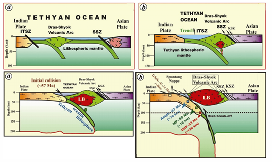
Map showing the formation of the Drass Volcanic Arc during the third phase of mountain building.
Phase 4 – : Major Thrusting and Rise of the Greater Himalayas
Squeezing reached its highest power: a massive crack in the Earth's crust called the Main Central Thrust (MCT) became the main engine that lifted the giant Greater Himalayas. The crust thickened greatly, lifting up hard, crystalline rocks to build the highest, snow-covered mountain peaks and changing the flow direction of major rivers.
- (i) Extreme sideways squeezing forced a massive slice of Earth's crust to slide over another.
- (ii) The Main Central Thrust (MCT) acted as the primary break line that pushed the Greater Himalayas skyward.
- (iii) This stage created the highest granite and crystalline mountain core and altered river paths across Asia.
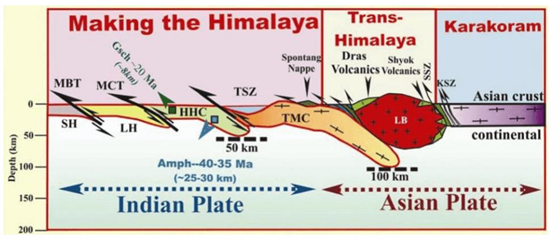
Illustration showing the uplifting of the Greater Himalayas along the Main Central Thrust line.
Phase 5 – (Miocene): Rise of the Lesser Himalayas
As thick mud and sand layers accumulated in southern lowlands, ongoing squeezing folded and pushed these deposits up to create the middle mountain belt known as the Lesser Himalayas. A major fault line called the Main Boundary Thrust (MBT) formed, separating the middle mountains from the high Greater Himalayas above them.
- (i) Layers of mud and sand piled up in lowlands were compressed and lifted to form the Lesser Himalayas.
- (ii) The Main Boundary Thrust (MBT) formed as a structural divide separating the Greater Himalayas from the Lesser Himalayas.
- (iii) This phase created middle-height mountain ranges, valleys, and complex landscapes.
Phase 6 – Rise of the Shiwalik Ranges (Latest Phase)
In the final chapter of mountain building, rivers flowing down from the high peaks dumped vast amounts of loose gravel, sand, and mud into the front lowland trench. Squeezing along a front crack called the Himalayan Frontal Fault (HFF) folded and lifted these young river deposits into the Shiwalik ranges (or Sub-Himalayas), which are the youngest and lowest mountain hills.
- (i) Himalayan rivers deposited thick layers of mud, gravel, and sand into the shallow front trench.
- (ii) Bending and cracking along the Himalayan Frontal Fault (HFF) lifted these soft river sediments into the Shiwalik hills.
- (iii) The Shiwalik hills are geologically very young, still active today, and suffer frequently from landslides and soil erosion.
Phases Illustration
Below is a visual timeline showing all six stages together, helping to connect each time period with real mountain formations.
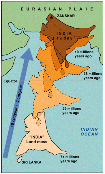
Comprehensive visual chart detailing the six consecutive stages of Himalayan orogenesis.
⚡ Quick Revision Capsule: Himalayan Mountain Building & Structural Features
Use this summary table to quickly review the key stages, fault lines, mountain belts, and time periods before your geography exams:
| Geological Phase & Time | Major Tectonic Event / Fault Line | Resulting Mountain Range or Landform |
|---|---|---|
| Phase 1 () | Rapid northward drift of the Indian Plate over volcanic hot spots | Initial narrowing and squeezing of the ancient Tethys Sea |
| Phase 2 () | Collision with crust; formation of Indus–Tsangpo Suture Zone (ITSZ) | Disappearance of ocean floor; initial uplift of the high Tibetan Plateau |
| Phase 3 () | Volcanic activity; creation of the Drass arc; plate spinning | Uplift of the Tethyan Himalayas marine rock layers |
| Phase 4 () | Major crustal thrusting along the Main Central Thrust (MCT) | Uplift of the snow-capped Greater Himalayas (Himadri) |
| Phase 5 () | Folding of foredeep sediments along the Main Boundary Thrust (MBT) | Uplift of the middle Lesser Himalayas (Himachal) |
| Phase 6 (Recent Geologic Time) | Folding of river gravel deposits along the Himalayan Frontal Fault (HFF) | Formation of the outer Shiwalik ranges and the Indo-Gangetic Plain |
📝 Summary & Exam Relevance
The formation of the Himalayas links fundamental principles of plate tectonics, paleogeography (the historical Tethys Sea), structural geology (key thrust fault lines: MCT, MBT, and HFF), and modern geography (the fertile Indo-Gangetic Plain, monsoon climate control, and earthquake risks). Always remember the time sequence: (initial plate drift) → (ITSZ formation and ocean floor closure) → Phases 3 to 6 ending with the uplift of the Greater, Lesser, and Shiwalik ranges. Today, India continues to push north at about , keeping these mountains actively growing.
🚀 Quick Revision Points
Essential facts to review before examinations:
- (i) The Himalayas are young, active folded mountains formed by a continent-to-continent collision between the Indian Plate and Eurasian Plate.
- (ii) Ancient marine limestone and sea fossils on Mount Everest prove that its rock layers originated on the ocean floor of the Tethys Sea.
- (iii) Three primary boundary faults divide the mountain zones: MCT (Greater Himalayas), MBT (Lesser Himalayas), and HFF (Shiwalik ranges).
- (iv) Soil washed off these rising mountains built the fertile Indo-Gangetic Plain described in classic texts like Geography of India.
- 💡 Exam Tip: In geography exam answers, always draw a simple sketch showing the relative positions of the three major faults (ITSZ, MCT, MBT, and HFF) from north to south alongside the three main mountain belts!
❓ Frequently Asked Questions (FAQ)
Q1: Why did neither plate sink underneath the other during the Himalayan collision?
A1: Both the Indian and Eurasian plates consist of light, buoyant continental crust of similar rock weight (density). Neither was heavy enough to sink into the Earth's mantle, forcing the land to crumple and fold upward instead.Q2: What is the Indus–Tsangpo Suture Zone (ITSZ)?
A2: The ITSZ is the primary structural scar line marking where the ancient ocean floor of the Tethys Sea completely closed, welding the Indian and Eurasian landmasses together.Q3: Why are ocean sea fossils found on top of Mount Everest?
A3: Mount Everest was formed when ocean floor mud layers from the ancient Tethys Sea were squeezed, folded, and lifted high into the sky during continental collision, as documented in geological studies such as Orogenesis and Earth History.
