
The mountain passes of India and neighboring regions play a main role in connecting places, helping with trade, and sharing cultures. From historic pathways like the Khyber Pass to high mountain routes in Ladakh and Sikkim, these natural gaps have been used for buying and selling goods, protecting borders, and traveling for hundreds of years. Learning about their whereabouts, defense importance, and natural features is very helpful for students who want to master geography and do well in their exams.
🎯 In this chapter, you will understand:
- How mountain passes act as natural gateways for travel, defense, and trade.
- The historical importance of key routes connecting Central Asia and South Asia.
- The location and features of major high-altitude Himalayan passes in India.
- The geography and purpose of natural gaps in the Deccan Plateau and Western Ghats.
💡 Why this topic matters: Mountain passes form vital paths through giant rock walls, allowing people, vehicles, and goods to move safely across steep landscapes.
🧠 Core Idea: A mountain pass is a lower, walkable path through a mountain ridge that connects two separated valleys or plains.
Importance and Strategic Significance of Mountain Passes in South Asia
Mountain passes are natural openings that connect different areas, making them very important for paths used by travelers, traders, and armies throughout history.
Natural Gateways: Resting high up in big mountain ranges, these passes act like open doors between communities. Because they are often near where rivers start, they split water flows and help people cross from one side to another.
- (i) Passes act as connectivity routes through tall, rocky mountains, linking isolated valleys to far-off lands.
- (ii) People have used them for trade, moving homes, and moving armies since ancient times.
- (iii) Many passes sit close to river sources, acting as water divides and natural walking paths between river valleys.
Mountain Passes in Pakistan – Historical and Geographical Significance
The passes in Pakistan connect Central Asia to the Indian subcontinent. They played a huge role in historical trade routes, past invasions, and the sharing of traditions.
Khyber Pass – Gateway to the Indian Subcontinent
Located in the Khyber Pakhtunkhwa province of Pakistan near the border of Afghanistan (Nangarhar Province), the Khyber Pass is one of the most famous historical paths in South Asia.
- (i) It joins Landi Kotal to the Valley of Peshawar at Jamrud right through the Spin Ghar Mountains.
- (ii) It was a major part of the ancient Silk Road, which helped people exchange goods and cultural ideas across Eurasia.
- (iii) It acted as a key military choke point when past rulers wanted to expand their empires.
- (iv) It made centuries of trade between Central Asia and South Asia possible.
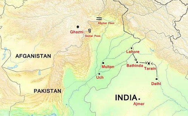
The historic Khyber Pass forming a narrow valley through tall mountains. 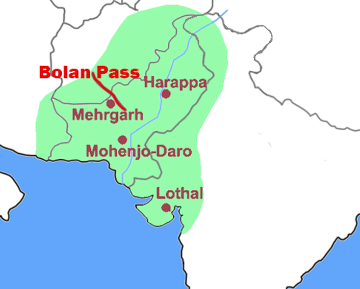
A high view of the rugged terrain surrounding Bolan Pass. Bolan Pass – The Gateway to Balochistan
The Bolan Pass is situated in the Toba Kakar Range in Balochistan province, roughly away from the Afghan border. It has long been an essential route for trade and travel between South Asia and Central Asia.
- (i) It runs for about along the Bolan River valley, starting from Rindli and ending near Darwāza close to Kolpur.
- (ii) It is filled with narrow gaps between mountains and sharp, steep cliffs.
- (iii) It lies to the southeast of Quetta and sits close to the very old historical settlement of Mehrgarh.
- (iv) The Toba Kakar Mountains form a southern branch of the great Himalayas range in Balochistan.
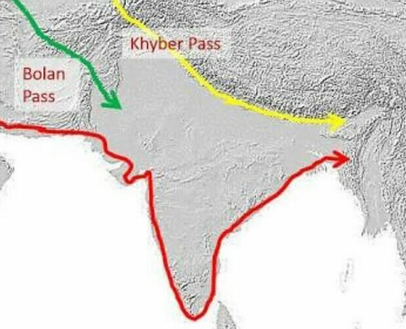
The winding mountain path of Bolan Pass in Balochistan.
Major Mountain Passes in India – Connectivity and Geopolitical Importance
India's mountain passes have always helped connect distant places, making trade, border protection, and cultural sharing easier. These routes go straight through the Himalayas, Karakoram, and other mountain ranges, linking India to Tibet, China, and Central Asia.
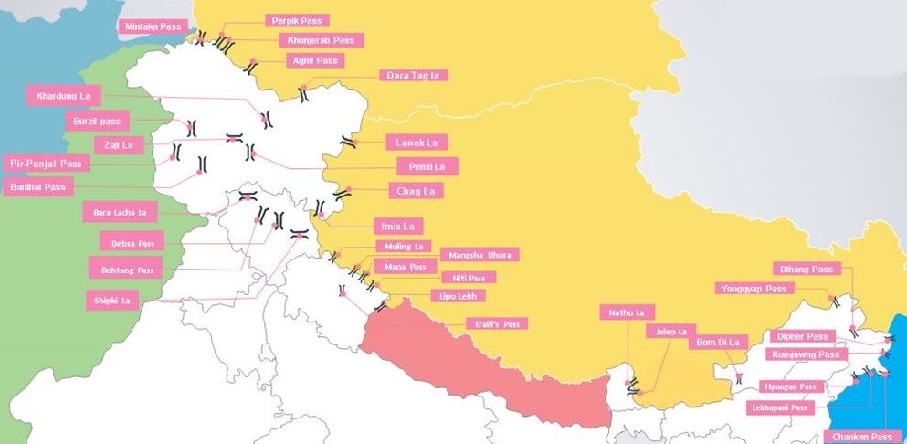
Map showing the location of main mountain passes across northern and eastern India. Zoji La Pass
Found in the Zaskar Range in Jammu & Kashmir, the Zoji La Pass sits on the main Srinagar-Leh highway and was shaped by the flowing water of the Indus River.
Banihal Pass
Sitting high in the Pir Panjal Range at a height of , this path connects the Kashmir Valley to the Outer Himalayas and the flat plains in the south. The word "Banihāl" means blizzard in the local Kashmiri language.
Shipki La Pass
Positioned right on the India-China border, this pass is an important border check post where the Sutlej River flows into India.
Bara-Lacha Pass
Located in the Zanskar Range, this route joins Himachal Pradesh to Leh along the Leh-Manali Highway, connecting the Lahaul and Ladakh regions.
Rohtang Pass
Set in the Pir Panjal Range of Himachal Pradesh, about away from Manali, the Rohtang Pass links the green Kullu Valley with the high Lahaul and Spiti Valleys.
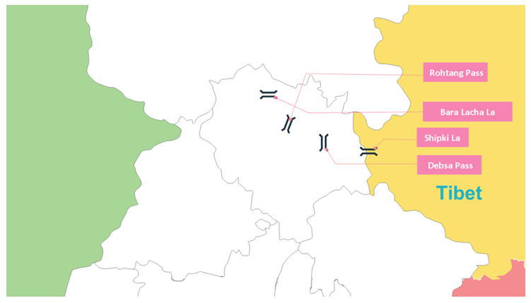
Key mountain routes across the state of Himachal Pradesh. Mana Pass
This path is one of the highest roads for vehicles in the world. It was built by the Indian military between the years and right on the India-China border.
Niti Pass
Located in Uttarakhand at an altitude of roughly , the Niti Pass links India and Tibet through a high Himalayan track.
Nathu La Pass
Found in East Sikkim, the Nathu La Pass joins India to the Tibet Autonomous Region (China). In the local language, "Nathu" means "listening ears" and "La" means pass.
Jalep La Pass
Situated in East Sikkim near the India-China border at a height of , this path connects Lhasa (Tibet) with India.
Mountain Passes in Leh & Ladakh – High Altitude Gateways
The Leh and Ladakh region has some of the highest drivable passes anywhere on Earth, connecting India to Central Asia and Tibet. These mountain roads are essential for defense, travelers, and local supply connections across the high Himalayas.
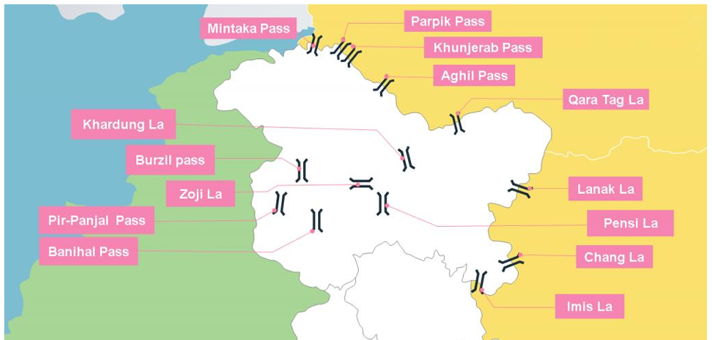
Khardung La Pass
This is celebrated as one of the highest drivable roads in India, linking Leh to the distant Siachen Glacier. Heavy winter snow forces it to close during cold months.
Thang La / Taglang La Pass
Known as the second-highest drivable pass in India, this high-altitude spot in Ladakh is a key section of the Leh-Manali Highway.
Aghil Pass
Set up high in the Karakoram Range, this pass connects Ladakh with Xinjiang, China. It remains blocked by heavy snow from .
Chang-La Pass
The Chang-La Pass links Ladakh with Tibet and serves as a major guard point for India's high mountain borders.
Lanak La Pass
This mountain gap joins Ladakh to Lhasa and was part of an old trading route through the high peaks.
Imis La Pass
Located in Ladakh, this steep trail connects Ladakh to Tibet. In older times, it was used by traveling traders and monks.
Bara-Lacha La Pass
Connecting Manali and Leh along the National Highway, this pass keeps the main road connection open between Jammu and Kashmir and Himachal Pradesh.
Summary – Importance of Mountain Passes in Geography and Defense
The mountain passes of India and neighboring lands hold huge geographic, historical, and strategic importance. They make cross-border trade possible, allow military vehicles to travel, and help different cultures share traditions over tricky land. For students preparing for exams, learning these passes builds a solid foundation in physical geography and regional defense connections.
Mountain Passes of India and Their Geographical Importance
The mountain passes of India are natural doors through tall ranges that help connect people, protect borders, and bring goods back and forth. From the snowy Himalayas in Uttarakhand and Kashmir to the green Western Ghats of the Deccan Plateau, every single pass has its own story of travel and defense. This topic appears often in geography exams, making it very helpful to learn.
Mountain Passes in Uttarakhand – Connecting the Himalayas
The Uttarakhand Himalayas feature several notable passes that connect deep valleys to Tibet. They are very important for trade routes, religious journeys, and border security.
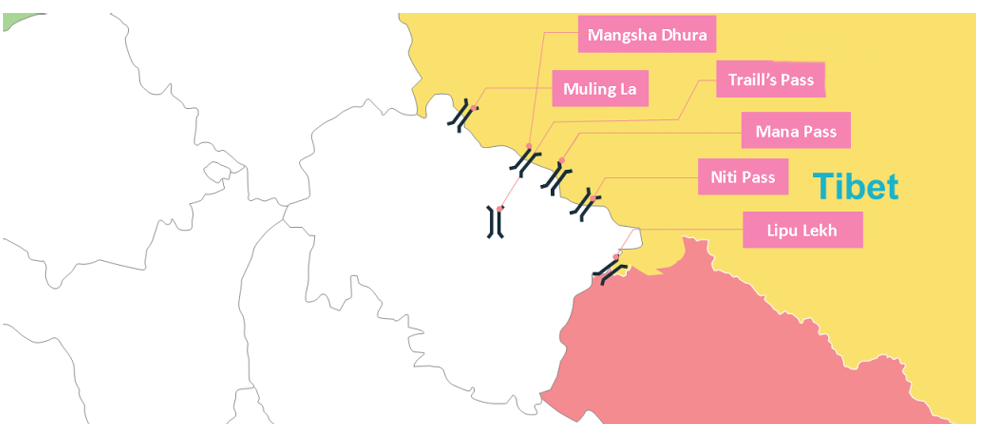
Traill’s Pass
Located in the Kumaon region, Traill's Pass joins the Pindari Valley to the Milam Valley. It has very steep, rocky land, making it a tricky mountain trail between big glaciers.
- (i) Sits right between the high peaks of Nanda Devi and Nanda Kot.
- (ii) Famous for mountain climbing adventures and ice glacier studies.
Lipu Lekh Pass
The Lipu Lekh Pass connects Uttarakhand to Tibet. It is a famous path for people taking the Kailash Mansarovar Yatra pilgrimage and aids trade between India and China.
- (i) Found in the Pithoragarh district.
- (ii) Works as a border trade path.
Mana Pass
Situated near the holy town of Badrinath, Mana Pass connects Uttarakhand with Tibet. It is one of the highest motorable roads on Earth and gets buried under snow during the cold winter.
- (i) Essential for military defense along the border.
- (ii) Historically served as an important trade path with Tibet.
Mangsha Dhura Pass
The Mangsha Dhura Pass lies along the border with Tibet. Because of frequent falling rocks and landslides, travelers must move across it with extra care.
Muling La Pass
The Muling La Pass is another high gap connecting Uttarakhand and Tibet. It gets covered with deep snow for parts of the year, making winter travel difficult.
Niti Pass
The Niti Pass connects India to Tibet through the Niti Valley. Snow covers this route for most of the year, but it remains critical for border patrols.
Mountain Passes in Northeastern States – Gateways to the East
The Northeastern region of India features key mountain openings that serve as paths for trade, defense, and cultural ties with neighboring places like Tibet and Myanmar.
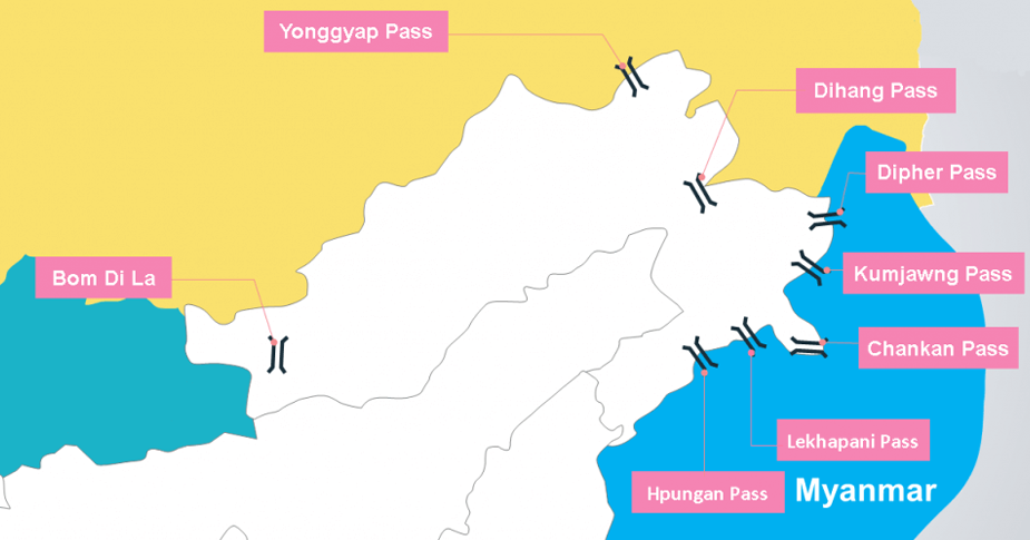
- Nathu La: A well-known trading point in Sikkim that formed part of the old Silk Route linking India with Tibet.
- Jelep La: Links Sikkim to Lhasa and has long been used for trade and travel.
- Bomdi-La: Located in Arunachal Pradesh, this pass connects to Lhasa and lies east of Bhutan.
- Yonggyap Pass: Serves as a mountain link joining Arunachal Pradesh and Tibet.
- Dihang Pass: Connects Arunachal Pradesh to Myanmar (Mandalay), showing India's eastern ground connections.
- Diphu Pass: A key strategic path in Arunachal Pradesh situated near the eastern border junction.
Mountain Passes in Kashmir – Northern Strategic Corridors
The Kashmir region is dotted with high mountain passes that act as vital transport and defense roads across the Himalayas. They link deep valleys and keep traffic moving throughout the year.
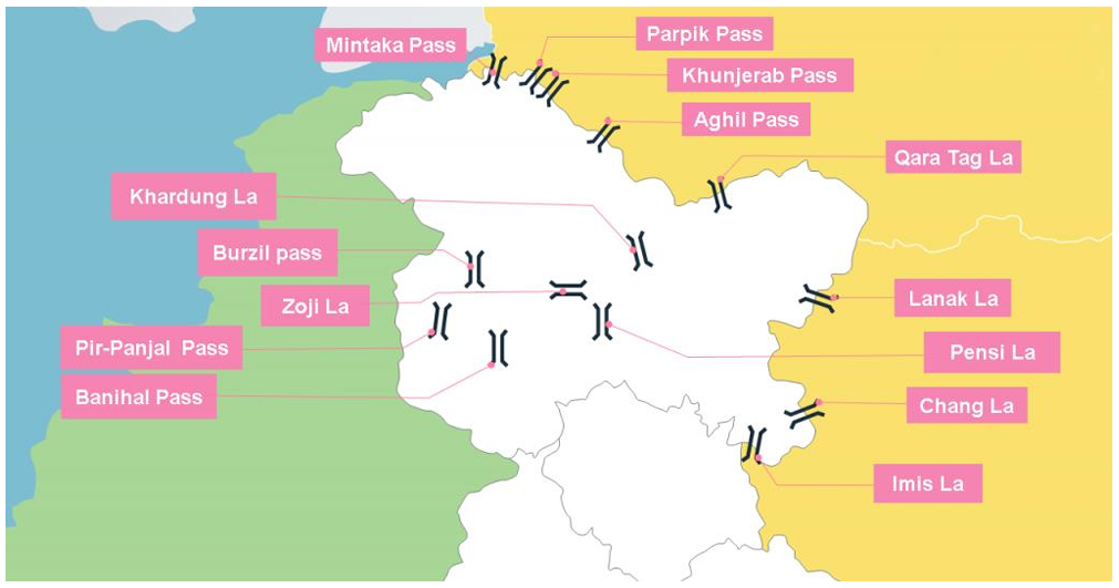
- Banihal Pass (Jawahar Tunnel): Connects Banihal to Qazigund in the Pir Panjal Range, acting as a crucial tunnel road for traffic.
- Zoji La: Links Srinagar to Kargil and Leh, continuously maintained by the Border Roads Organization.
- Burzail Pass: Connects the Astore Valley to the Deosai Plains, serving military transport needs.
- Pensi La: Located in the Greater Himalayas, it connects the Kashmir Valley to Kargil and marks the entry point into Zanskar.
Mountain Passes in Deccan Plateau (Central & Southern India)
The Deccan Plateau and the Western Ghats have natural gaps in the hills that serve as roads, trade gaps, and scenic spots across Maharashtra, Tamil Nadu, Kerala, and Madhya Pradesh.
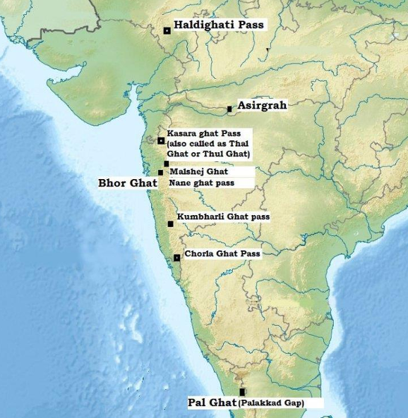
- Shencottah Gap: Connects Madurai with Kottayam, providing a major rail and road link between Tamil Nadu and Kerala.
- Bhor Ghat: Links Palasdari to Khandala, forming a busy mountain highway in Maharashtra.
- Thal Ghat: Connects Kasara in Maharashtra and features one of India's steepest railway routes.
- Palakkad Gap: Joins Coimbatore to Palakkad, serving as a historic gap through the Western Ghats.
- Asirgarh Pass: Known as the “Key to the Deccan”, it links the Narmada River valley to the Tapti River valley in Madhya Pradesh.
- Goram Ghat: Located in Rajasthan, it connects Mewar and Marwar across the Aravali Hills.
- Haldighati Pass: Famous for the historical Battle of Haldighati, named for its distinct turmeric-yellow soil.
- Jabalpur Gap, Khandwa Gap & Burhanpur Gap: Natural openings in Madhya Pradesh that help vehicles cross Central India.
- Amba Ghat: A scenic pass in Maharashtra famous for tourism and paragliding activities.
- Chorla Ghat: Lies where the borders of Goa, Karnataka, and Maharashtra meet, surrounded by dense nature.
- Malshej Ghat: Known for rich plant life and animals, acting as an ecological path in Maharashtra.
- Naneghat Pass: An ancient trade path used for collecting tolls in historic times.
- Tamhini Ghat: Links Mulshi to Tamhini, famous for green hills and waterfalls.
- Amboli Ghat: Connects Sawantwadi to Belgaum, surrounded by peaceful forests.
- Kumbharli Ghat: Joins the Ratnagiri and Satara districts together, helping regional travel.
⚡ Quick Revision Capsule: Mountain Passes of South Asia
A structured quick-reference list of key mountain passes, their locations, and why they matter:
| Pass Name | Location / Range | Connecting Regions / Significance |
|---|---|---|
| Khyber Pass | Spin Ghar Mountains (Pakistan-Afghanistan) | Connects Landi Kotal to Peshawar; historic part of the Silk Road. |
| Bolan Pass | Toba Kakar Range (Balochistan) | Links South Asia to Central Asia near ancient Mehrgarh. |
| Zoji La Pass | Zaskar Range (Jammu & Kashmir) | Connects Srinagar with Leh across the Indus River basin. |
| Khardung La Pass | Ladakh Range (Ladakh) | High motorable pass connecting Leh to the Siachen Glacier. |
| Nathu La Pass | East Sikkim | Border post linking India to Tibet; historic trade route in Silk Road History. |
📝 Summary
Mountain passes across South Asia serve as natural gateways through massive barriers like the Himalayas, Karakoram, and Western Ghats. For centuries, these routes have shaped trade routes, facilitated cultural exchange, and served as critical strategic lines for border defense from ancient times through modern history.
🚀 Quick Revision Points
Essential facts to review before examinations:
- (i) Khyber Pass and Bolan Pass were historical entry corridors from Central Asia into the Indian Subcontinent.
- (ii) Zoji La, Rohtang Pass, and Khardung La are critical transport routes in northern India.
- (iii) Passes in Sikkim such as Nathu La and Jelep La connect eastern India with Tibet.
- (iv) Southern passes like Palakkad Gap and Bhor Ghat link coastal regions across the Western Ghats as detailed in Physical Geography of India.
- 💡 Exam Tip: Map questions frequently test the location of mountain passes from West to East across the Himalayas. Practice plotting Zoji La, Shipki La, Lipu Lekh, Nathu La, and Bomdi-La in sequence!
❓ Frequently Asked Questions (FAQ)
Q1: What is a mountain pass?
A1: A mountain pass is a navigable route or gap through a mountain range or over a ridge that allows travel between valleys or regions.Q2: Which mountain pass connects Srinagar to Leh?
A2: The Zoji La Pass in the Zaskar Range connects Srinagar with Leh.Q3: What is the strategic importance of passes in Ladakh and Sikkim?
A3: Passes like Khardung La and Nathu La provide critical defense supply access along border areas and were historically vital sections of the Ancient Silk Route system.
