
The Aravalli Hills, Vindhyan Range, and Satpura Range are very old and important landforms made of rocks and soil located in India's Peninsular Plateau. They give us rich geographical insights that help students prepare for big exams like UPSC, SSC, and State PSC. These super old mountain systems were made millions of years ago through tectonic and non-tectonic processes, which means the Earth pushed, cracked, or moved over time. Because of this, they now shape our biggest rivers, store super valuable minerals underground, and give homes to many plants and animals. Learning about their origin (how they started), geology (what kinds of rocks they are made of), and ecological importance (how they help nature and wildlife) is very easy and essential for geography students and civil service aspirants.
🎯 In this chapter, you will understand:
- How ancient mountains like the Aravallis, Vindhyas, and Satpuras were created millions of years ago.
- The special high peaks, major rivers, and natural gap passes hidden across these ranges.
- The big differences in climate, height, and plant life between the Western Ghats and Eastern Ghats.
- Why the Peninsular Plateau is super important for mining, farming, rain, and wildlife protection.
💡 Why this topic matters: These mountain ranges control how the monsoon rain moves across India, where our major rivers flow, and where we find key natural resources like diamonds, marble, and iron.
🧠 Core Idea: Peninsular India's mountains act as natural climate walls, giant water towers for rivers, and massive treasure boxes of ancient rocks and minerals.
📌 Major Mountain Ranges of Peninsular India – Aravalli, Vindhya & Satpura (Geological & Geographical Overview)
The Aravalli Range is one of the oldest fold mountains in the whole world, stretching across western and northern parts of India with huge historical, rock-forming, and natural importance. The Aravalli Hills start in Gujarat and go all the way to Delhi. They play a giant role in shaping local weather, storing valuable rocks and minerals, and starting river pathways. They also hold India's oldest stone layers along with famous tall peaks and mountain paths.
- (i) The origin of the Aravallis begins in Palanpur, Gujarat.
- (ii) They stretch all the way up to the Delhi Ridge, working like a tall wall made by nature.
- (iii) These hills are ancient, containing rocks, and some parts rise higher than 1000 meters into the sky.
Aravalli Range – Geographical & Geological Features
The Aravalli Hills show us many different landscapes, very famous high points, key rivers, rich underground minerals, and lots of beautiful mountain passes and lakes across Rajasthan and Gujarat.
Topography and Highest Peaks of Aravallis
The Aravalli Range has many raised lands, flat-topped plateaus, and rolling hills. Its most famous peaks include Mt. Gurushikhar and Mt. Abu in Rajasthan, which are very famous for travel and strategy.
- (i) Mt. Gurushikhar (1722 m) – The highest single point in the whole Aravalli mountain range.
- (ii) Mt. Abu (1158 m) – Famous for its cool hill station and giant granite rock plateau.
- (iii) Includes many wide green forests and rocky areas where wild animals live safely.
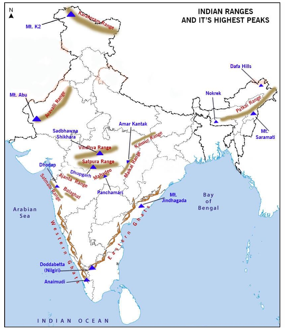
Map showing major Indian mountain ranges and their highest peaks.
Geology and Mineral Resources in Aravallis
These hills are mostly made of super old Dharwar igneous and metamorphic rocks. They are packed with rich marble deposits, which makes this area super critical for India's stone mining factories.
- (a) Ancient Dharwar rock layers show us how early these mountains were formed on Earth.
- (b) Rajasthan holds India's biggest reserves of marble stone underground.
- (c) These huge stone reserves power local rock-cutting and building industries.
Rivers, Passes, and Lakes Associated with Aravalli Hills
Several crucial rivers like the Banas, Luni, and Sabarmati start inside or travel through this range. The hills also protect historic land gaps called passes and big lakes.
- Rivers: Banas (a major side-stream feeding the Chambal River), Luni (a river that flows west into the salty marshes of the Rann of Kutch), and Sabarmati.
- Passes: Important gap paths through the mountains include Piplighat, Dewair, and Desuri.
- Lakes: Sambhar (India's largest inland salt lake), Dhebar, and Jaisamand.
Vindhyan Range – Formation, Structure & Characteristics
The Vindhyan Range is younger than the Aravalli Hills. It reaches across central India and is famous for its non-tectonic fault creation, flat-topped tablelands, and rich diamond-bearing ground.
Formation and Geological History
This mountain range was created when land sank downward to form the Narmada Rift Valley. This makes it a non-tectonic mountain system built mostly out of horizontal layers of super old Proterozoic rocks.
- (i) Spans across a long distance of 1200 km from Gujarat all the way to Bihar.
- (ii) Made mostly of flat, layered sedimentary rocks stacked like pages in a book.
- (iii) Famous for rich diamond deposits hidden inside deep rock pipes called Kimberlite intrusions.
Topography and Local Names
The Vindhyas feature very steep cliffs called escarpments, especially in places like Panna, Kaimur, and Rewa. Their average height ranges from 300 to 650 meters.
- (a) Known locally by nearby names such as Panna Hills and Kaimur Hills.
- (b) Home to India's primary diamond mining areas inside the Panna district of Madhya Pradesh.
- (c) Acts as a natural wall separating the flat northern Indo-Gangetic Plains from the southern Deccan Plateau.
Satpura Range – Geological Formation, Ecology & Resources
The Satpura Range sits right to the south of the Vindhya Range. It was created by very old Earth movements that pushed land upward, forming a group of hills, tablelands, dense forests, and rich mineral zones.
Origin and Structure of Satpura Hills
The Satpuras were born when subterranean forces pushed the land up, forming a raised block structure called a Horst landform. This eventually shaped three main hill groups: Satpura, Mahadeo, and Maikala.
- (i) Stretches out for roughly 900 km across central India.
- (ii) Packed full of ancient rock layers known as the Gondwana rock system.
- (iii) Stands as one of the oldest upward mountain pushes in the Indian subcontinent.
Plateaus and Highest Points
Known for beautiful green plateaus and high hilltops like Pachmarhi and Amarkantak, the Satpura range acts as a major water divide for rivers running toward the Bay of Bengal and the Arabian Sea.
- (a) Dhupgarh (1350 m) – The highest mountain top located in the Pachmarhi hill region.
- (b) Amarkantak (1127 m) – The special hilltop where both the Narmada and Son rivers begin flowing.
- (c) Decorated with famous roaring water cascades like the scenic Dhuandhar Falls.
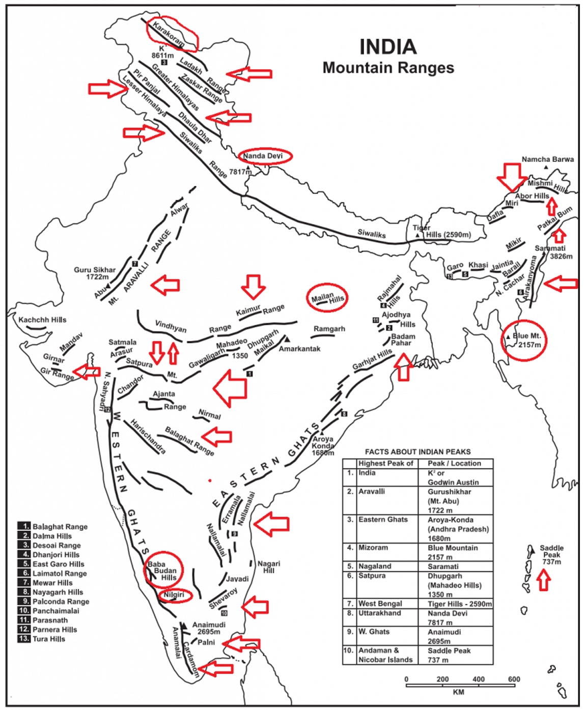
Overview diagram showing major hill ranges across central Peninsular India.
Drainage, Minerals, and Biodiversity
The Satpuras are filled with rich plant and animal life, dark green forests, mining resources, and river origins that feed central Indian nature reserves.
- Rivers: Narmada (travels west toward the Arabian Sea) and Son (travels east to join the Ganges).
- Minerals: Rich in bauxite ore found inside the Gondwana rock beds.
- Forests: Houses major tiger reserves and protected wildlife sanctuaries.
Summary of Major Mountain Ranges of Peninsular India
The Aravalli, Vindhya, and Satpura ranges represent the oldest and most complex rock systems of India. They guide how our rivers flow, where mineral deposits sit, and how local wildlife thrives. Studying these hills is crucial for geography students preparing for UPSC and other competitive exams because they teach us about physical landscapes, ecosystems, and natural resource maps spanning across Gujarat, Rajasthan, Madhya Pradesh, and Bihar.
The Western Ghats and Eastern Ghats of Peninsular India are very old, green, and important high mountain walls. They play a giant role in Indian climate, biodiversity, and cultural evolution. These mountain chains date all the way back to the ancient . They direct monsoon rainfall patterns, river drainage paths, and host thousands of special flora and fauna (plants and animals), many of which live nowhere else on Earth.
Western Ghats and Eastern Ghats: Geographical Features, Biodiversity, and Significance in India
Understanding the major physiographic features of Peninsular India through the Western Ghats and Eastern Ghats. The Western and Eastern Ghats form the strong spine of the Indian Peninsula. They show super clear contrasts in how they started, how tall they stand, how much rain they get, and the kinds of rocks they hold.
- (i) Western Ghats: A long, unbroken mountain edge that forms the western wall of the Deccan Plateau.
- (ii) Eastern Ghats: A broken chain of ancient fold mountains running right along the eastern coastline.
- (iii) Both ranges control the weather, river networks, and animal habitats of southern India.
Western Ghats: Detailed Geographical and Ecological Analysis
The Western Ghats, also popularly called the Sahyadris, stretch all the way from Gujarat down to Kerala. They stand like a giant tall wall blocking the rain-filled summer wind monsoon.
Formation and Key Features of Western Ghats
The Western Ghats were created due to the slanted tilting of the Peninsular block and the sinking of the Arabian sea floor back when the Himalayas were being pushed up. Their sharp, steep western edge and gently sloping eastern side make them look like giant block mountains with a stair-like Treppen formation.
- (i) Origin: Born from powerful Earth movements during the Himalayan mountain-building era.
- (ii) Topography: Very steep cliffs facing the west coast, turning into gentle sloped plateaus toward the east.
- (iii) Spread: Reaches across six states: Gujarat, Maharashtra, Goa, Karnataka, Tamil Nadu, and Kerala.
Biodiversity and Monsoon Impact
The Western Ghats are counted among the world's eight hottest hotspots of nature diversity and are officially marked as a famous UNESCO World Heritage Site. They guide India's weather by stopping the heavy southwest monsoon winds, forcing them to dump huge amounts of rain on the west coast.
- (a) Dense forests: Green home to over 7,400 different flowering plant species.
- (b) Endemic species: Protects over 325 animal and plant species that are threatened with extinction worldwide.
- (c) Monsoon wall: Catches rain-clouds directly, powering Indian farming and water supply.
Sectional Analysis of the Western Ghats
The Western Ghats are split into three main regions based on location and rock type, with each region showing special peaks and famous history.
- Northern Western Ghats: Runs between the Tapi Valley and line, made mostly of dark basalt rock from Deccan lava flows.
- Notable peaks: Kalsubai (1,646 m) and Mahabaleshwar (1,438 m).
- Important passes: Thal Ghat and Bhor Ghat.
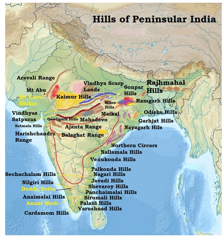
Terrain map detailing the mountain structures of the Western Ghats.
- Middle Sahyadri (Central Western Ghats): Built from tough granite and gneiss rocks. This section features high tops like Vavul Mala (2,339 m) and Kudremukh (1,892 m), and houses the famous Nilgiri Hills.
- (i) The starting home of the Kaveri River up in the Brahmagiri Hills.
- (ii) Jog Falls: One of the tallest tumbling waterfalls in India.
- Southern Western Ghats: Located past the natural mountain gap called the Palakkad Gap, featuring the tallest mountain peaks such as Anai Mudi (2,695 m).
- (i) Anai Mudi: The absolute tallest mountain peak in all of South India.
- (ii) Palani and Cardamom Hills: Covered with rich plantations growing aromatic spices.
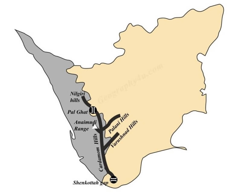
Detailed geographical overview of the Southern Western Ghats in Kerala and Tamil Nadu.
- Northern Western Ghats: Runs between the Tapi Valley and line, made mostly of dark basalt rock from Deccan lava flows.
Eastern Ghats: Detailed Geographical and Ecological Analysis
The Eastern Ghats are ancient, broken fold mountains running alongside the Bay of Bengal coast all the way from the Mahanadi River in Odisha to the Vaigai River in Tamil Nadu.
Geographical and Geological Features
The Eastern Ghats are made of separated hill ranges that have been worn down by wind and water over millions of years. While the upper northern section stays somewhat connected, the lower southern part is cut into pieces by big flowing rivers like the Godavari and Krishna.
- (i) Height: Generally much lower than the west coast—ranging between 150 to 300 meters high.
- (ii) Geology: Mostly super old Precambrian rocks like Khondalite and Granitic Gneiss.
- (iii) Valleys: Deeply carved out by rivers, creating wide U-shaped pathways.
Notable Peaks and Ranges of the Eastern Ghats
Even though they are not as tall as the Western Ghats, the Eastern Ghats hold unique hilltop peaks and plateaus filled with rich minerals and native tribal villages.
- (a) Maliya Range: Home to Mahendra Giri peak (1,501 m).
- (b) Madugula Konda Range: Holds Jindhagada Peak (1,690 m), the highest point here.
- (c) Southern Ghats: Includes the Javadi Hills and Biligiri Rangan Hills (1,279 m).
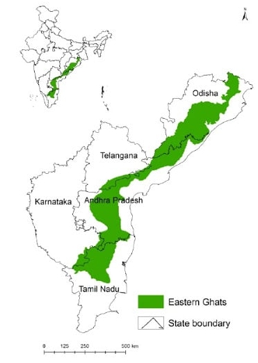
Map showing the broken ranges and state boundaries of the Eastern Ghats.
Hydrological Importance
The rivers carving across the Eastern Ghats create wide U-shaped valleys and flat rock terraces. The Indravati River is one of the unique streams that starts right inside these hills.
- (i) Delivers valuable water for farming across flat coastal farmlands.
- (ii) Supplies raw minerals to nearby manufacturing plants.
- (iii) Helps feed water and fertile silt to the rich deltas of the Godavari and Krishna rivers.
⚡ Quick Revision Capsule: Comparison Between Western Ghats and Eastern Ghats
This side-by-side table makes it super simple to understand the structural, height, and weather differences between the Western Ghats and Eastern Ghats for exam preparation.
| Feature | Western Ghats (Sahyadris) | Eastern Ghats |
|---|---|---|
| Average Height | 600–1200 m (gets much taller in the south) | 150–300 m (much lower overall) |
| Rock Composition | Basalt (Deccan Traps), Charnockite, and Granite | Ancient Gneiss, Khondalite, and Dharwar rocks |
| Mountain Origin | Block mountains formed by land tilting and sinking | Heavily eroded, broken ancient fold mountains |
| Water Divide Role | Major watershed starting almost all major south Indian rivers | Poor watershed; heavily cut through by major rivers |
| Forest & Soil Type | Dense rainforests with rich Laterite soils | Dry-to-moist deciduous forests with Red Sandy soils |
| Annual Rainfall | 150+ cm (very heavy rain along the west coast) | 60–100 cm (moderate rain along the east coast) |
Significance of the Peninsular Plateau: Economic, Geographical, and Cultural Importance
The Peninsular Plateau, wrapped on both sides by the Western and Eastern Ghats, is a region of huge economic, ecological, and cultural importance. It stores rich minerals, evergreen forests, popular hill stations, and rich river valleys.
- (i) Mineral Wealth: Packed with iron ore, manganese, copper, coal, bauxite ore, and natural gold.
- (ii) Soil Fertility: Covered with moisture-retaining black cotton soil and nutrient-rich red soils.
- (iii) Agriculture: Ideal for growing tea, coffee, cardamom spices, and rice crops.
- (iv) Forestry: Gives us high-value timber wood along with thick animal habitats.
- (v) Rivers: Swift west-flowing rivers create great chances to generate clean hydroelectric power.
- (vi) Tourism: Beautiful cool holiday hill spots like Ooty, Mahabaleshwar, Kodaikanal, and Pachmarhi.
Conclusion: Why the Western and Eastern Ghats Matter for India and Students
The Western Ghats and Eastern Ghats are far more than just long rows of stone hills; they are the true lifelines of southern India's weather, environment, financial growth, and culture. Learning about them is essential for candidates preparing for
📝 Summary
Peninsular India's mountain ranges—including the ancient Aravalli Hills, the Vindhyan and Satpura ranges in central India, and the coastal Western and Eastern Ghats—form the structural foundation of the Indian subcontinent. Originating over up to the , these ranges direct monsoon winds, feed major river systems like the Narmada, Son, and Kaveri, and store vast mineral wealth. As documented in geographical texts like Physical Geography of India, understanding these landforms is crucial for mastering physical geography, natural resources, and environmental ecology.
🚀 Quick Revision Points
Essential facts to review before examinations:
- (i) The Aravalli Range contains rocks over old and has its highest point at Mt. Gurushikhar (1722 m).
- (ii) The Vindhya Range is a non-tectonic mountain formed by sedimentary layers, famously containing diamond-rich Kimberlite deposits in Panna.
- (iii) The Satpura Range is a classic Horst block mountain whose highest peak is Dhupgarh (1350 m) in Pachmarhi.
- (iv) The Western Ghats host Anai Mudi (2,695 m)—the highest peak in South India—and are recognized as a UNESCO World Heritage hotspot, as highlighted in Indian Physical Environment.
- 💡 Exam Tip: Remember that rivers flowing west (like Narmada and Tapti) cut through rift valleys between the Vindhya and Satpura ranges and form estuaries, while rivers flowing east across the Ghats form major deltas at the Bay of Bengal!
❓ Frequently Asked Questions (FAQ)
Q1: What is the highest peak in South India, and where is it located?
A1: The highest peak in South India is Anai Mudi, standing at 2,695 meters, located in the Southern Western Ghats of Kerala.Q2: How do the geological origins of the Western Ghats and Eastern Ghats differ?
A2: The Western Ghats formed as block mountains due to continental tilting during Himalayan uplift, whereas the Eastern Ghats are ancient, highly eroded fold mountains carved into disconnected hills by rivers.Q3: Why are the Vindhya and Satpura ranges economically important?
A3: As outlined in Geography of India, these ranges contain rich deposits of diamonds in Panna, bauxite in Gondwana rock strata, and abundant sedimentary rock layers vital for mining and construction industries.
