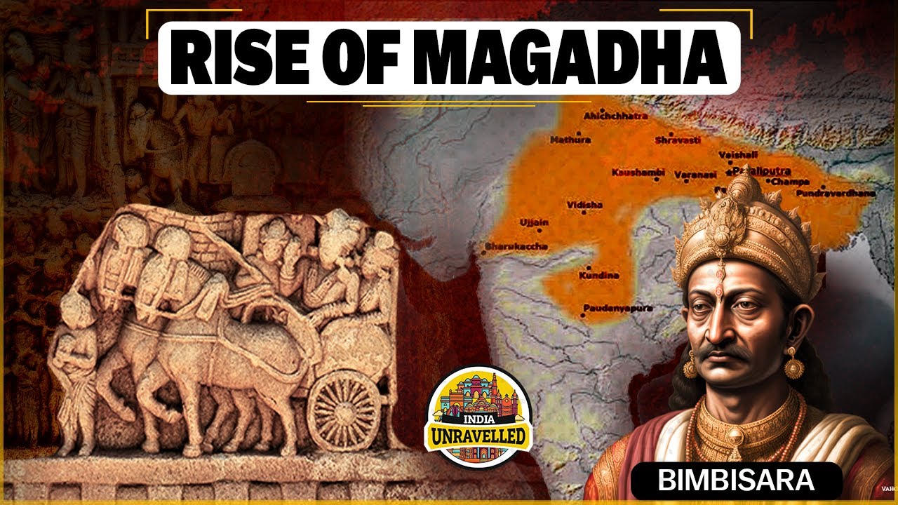
The political landscape of ancient India underwent a dramatic change around the . Small clan-based settlements gradually gave way to larger, centralized territories known as the Mahajanapadas. This shift marked the beginning of true state formation across the Gangetic plains, driven by widespread agricultural expansion and the strategic use of iron technology. Out of these sixteen great kingdoms, Magadha ultimately emerged as the most dominant power, laying the foundation for India's first historical empire.
In this chapter, you will understand:
- The transition from tribal Janapadas to territorial Mahajanapadas
- The structural differences between monarchies and Gana-Sanghas
- Economic growth driven by iron tools, paddy transplantation, and taxation
- The strategic, military, and geographical factors behind the rise of Magadha
Why this topic matters: This era marks the Second Urbanization of India, establishing fundamental political structures, administrative systems, and socio-religious movements that shaped ancient Indian history.
Core Idea: Technological advances in iron production enabled widespread agriculture and surplus food creation. This surplus supported standing armies, administrative staff, and urban centers, prompting intense competition among the 16 Mahajanapadas until Magadha consolidated regional control.
Evolution of Territorial States: Mahajanapadas and Magadha Dominance in 6th Century BCE
The mid-first millennium BCE opened a transformative chapter in early Indian history, seeing small agrarian communities combine into structured regional kingdoms. Early texts provide crucial details about these territorial units and their geographical footprints.
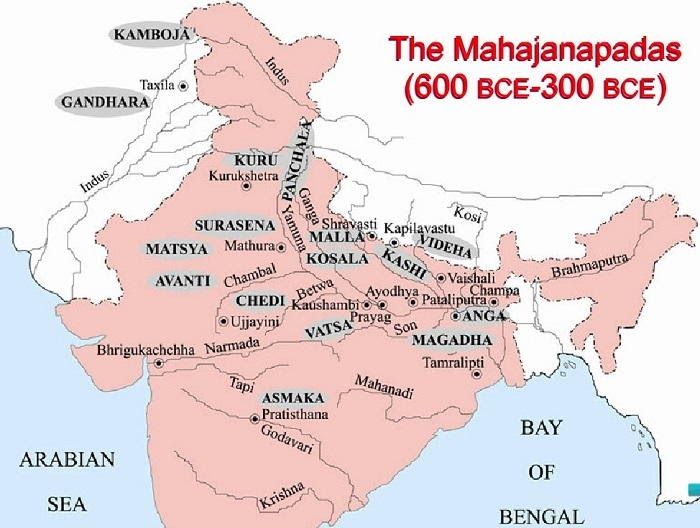
The early Buddhist textAnguttara Nikaya provides the earliest list of the 16 Mahajanapadas that grew out of the simpler political setups of the late Vedic Age.
- (i) Growth was centered primarily in eastern Uttar Pradesh and Bihar, where natural resources supported larger populations.
- (ii) Agricultural expansion thrived across fertile river lands, generating the consistent food supply required to build permanent towns.
- (iii) Abundant local iron ore deposits accelerated iron production, providing sturdy farm tools alongside stronger weapons for political defense and expansion.
Janapada to Mahajanapada Transformation: Key Factors Driving Political Growth
The shift from clan-based settlements to large territorial entities marked a major shift in how rulers organized land, taxation, and military power.
Origins of Janapadas and Territorial Identity
The term Janapada combines two ancient terms that reflect a settled population's connection to its land.
- (i) Jana refers to the community or tribe.
- (ii) Pada means foot or foothold, signifying the land where a clan permanently settled.
Catalysts for Mega-State Formation: Why the 16 Kingdoms Emerged
By , roughly 22 smaller units had reorganized into 16 major territorial states due to several shared economic and political drivers.
- (a) Heavy iron implements improved soil tilling and equipped well-armed troops.
- (b) Ambitious leaders expanded their borders by absorbing weaker neighboring lands.
- (c) Settled trade along key river routes produced reliable revenue to fund local governance and defense.
Sixteen Great Kingdoms: A Geographical Survey of the Mahajanapadas
These kingdoms spanned distinct geographic regions across the subcontinent, establishing unique local trade hubs and cultural centers.
Geographical Distribution of Mahajanapadas
The major states occupied distinct economic and strategic corridors across northern, central, and northwestern regions.
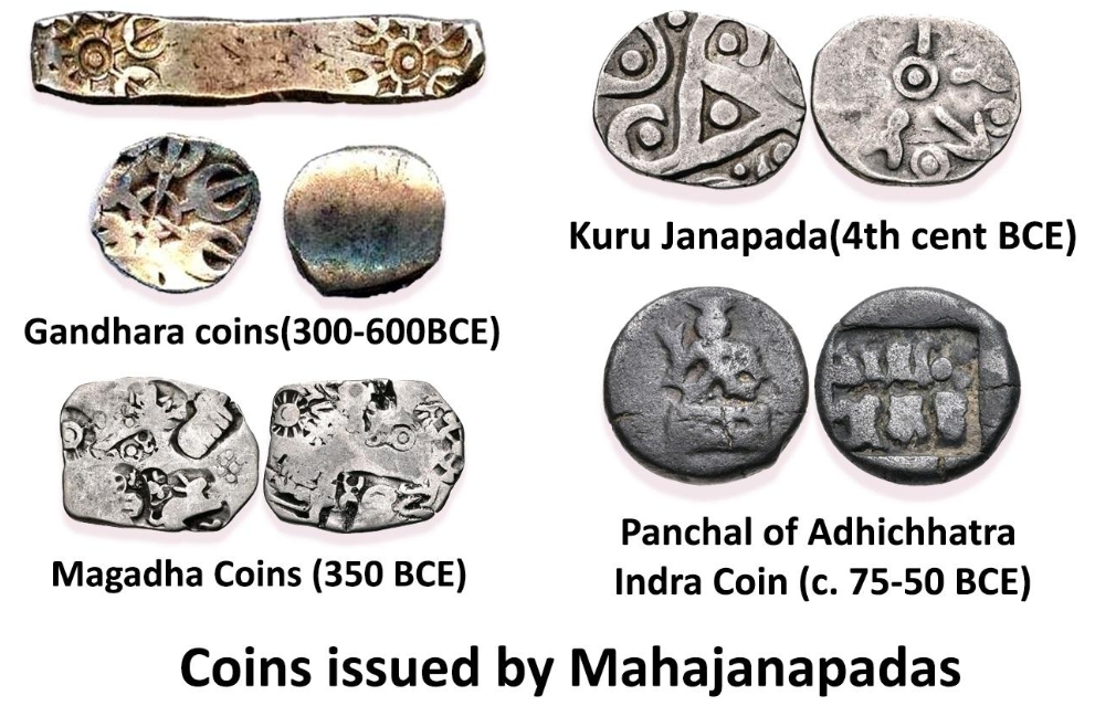
Early metallic punch-marked coins issued during the Mahajanapada era - (i) Indo-Gangetic Plain: Home to states like Kuru, Panchala, Matsya, Surasena, Vajji, Malla, Kasi, and Kosala.
- (ii) Eastern India: Included Anga and the rising power of Magadha.
- (iii) Central India: Comprised Chedi, Vatsa, and Avanti.
- (iv) Western & Southern Margins: Included Assaka (Asmaka) along the Godavari River.
- (v) Northwest Frontiers:Gandhara and Kamboja linked regional trade with international routes.
Diverse Political Systems: Monarchies and Republican States (Gana-Sanghas)
Government structures fell into two primary models: centralized hereditary monarchies and collective oligarchic republics.
Features of Mahajanapada Administration
While their governance mechanisms differed, both systems developed formal administrative bases and defensive networks.
- (i) Monarchies relied on kingship, whereas republics operated under shared clan leadership.
- (ii) Republics chose leaders through executive councils drawn from prominent landed families.
- (iii) The Vajji confederacy based at Vaishali served as a notable example of non-monarchical rule.
- (iv) Every state established a fortified administrative center to serve as its functional capital.
- (v) Fortified walls guarded capital cities against surprise incursions by aggressive neighbors.
- (vi) Rulers raised professional standing armies to protect trade lines and enforce internal order.
Gana-Sanghas: The Republican Experiment in Ancient India
The Gana-Sangha model offered an alternative governance path where elite assemblies shared authority rather than concentrating it in a single king.
Functioning and Characteristics of the Republics
Decisions in these republics passed through formal debate and joint council votes.
- (a) Governance authority rested with representative assemblies rather than a single hereditary lineage.
- (b) Members gathered at a central assembly hall known as the Santhagara to debate state affairs.
- (c) Voting mechanisms helped resolve disputes regarding defense, taxation, and legal claims.
- (d) The Vrijji (Vajji) confederacy demonstrated how allied clans could effectively manage shared defensive networks.
Monarchical System and Taxation in the Gangetic Plains
Monarchies along the fertile Gangetic basin relied on systematic taxation to maintain state operations, public officials, and regular troops.
Kingship, Administration, and Revenue Generation
Centralized monarchies developed fixed tax structures to secure predictable annual revenue.
- (i) Royal succession followed hereditary rules, passing authority down through primary lineage.
- (ii) Priestly advisers played prominent roles in state rituals, bolstering royal legitimacy.
- (iii) Regularized taxes supplied the wealth necessary for public works, defensive walls, and military upkeep.
- (iv) The primary agricultural tax was the Bhaga, set at 1/6th of total harvested produce.
- (v) Earlier customary gifts evolved into mandatory state levies such as Bali.
Economic Boom: Iron Plowshares and Advanced Agricultural Techniques
Innovations in farming methods dramatically increased crop yields, allowing governments to expand their tax bases and support non-farming urban workers.
New Methods of Production and Tax Base Expansion
Governments expanded tax collection beyond farming to include urban artisans, merchant guilds, and livestock herders.
- (i) Agriculture remained the economic cornerstone of all Mahajanapada revenue systems.
- (ii) Craftsmen and merchants paid monthly labor or goods contributions to state treasuries.
- (iii) Heavy iron plowshares allowed farmers to turn dense alluvial soils much deeper than before.
- (iv) Farmers adopted systematic paddy transplantation, which increased overall rice harvests.
Socio-Religious Change: The Rise of Buddhism and Jainism
Rapid economic shifts and urban growth created fertile ground for new philosophical movements that questioned established ritual hierarchies.
Challenge to Vedic Orthodoxy and Republican Patronage
New reform movements found strong support among merchant communities and democratic assemblies.
- (i) Buddhism and Jainism emerged as major spiritual paths during this period of political transformation.
- (ii) Both traditions questioned rigid caste hierarchies and costly ritual sacrifices.
- (iii) Republican centers provided open environments where new philosophical ideas could spread freely.
- (iv) Spiritual teachers like Gautama Buddha and Mahavira grew up in republican societies, influencing their approach to community governance.
The Ascendancy of Magadha: The Road to Empire
Among all competing kingdoms, Magadha held clear geographic, industrial, and military advantages that enabled it to defeat regional rivals.
Strategic Political Landscape in Sixth Century B.C.
Four major states—Magadha, Kosala, Vatsa, and Avanti—eventually consolidated smaller neighbors before turning their forces against one another.
- (i) Extensive iron deposits provided Magadha with raw materials for weapons and farm implements.
- (ii) Superior iron weaponry strengthened infantry forces on the battlefield.
- (iii) High crop yields fed urban populations and sustained large military campaigns.
- (iv) While 16 states initially emerged, Magadha eventually proved strongest among the top four powers.
Magadha and Rival Mahajanapadas: Key Geographical Centers
Control over critical trade rivers and strategic valley capitals dictated regional political outcomes.
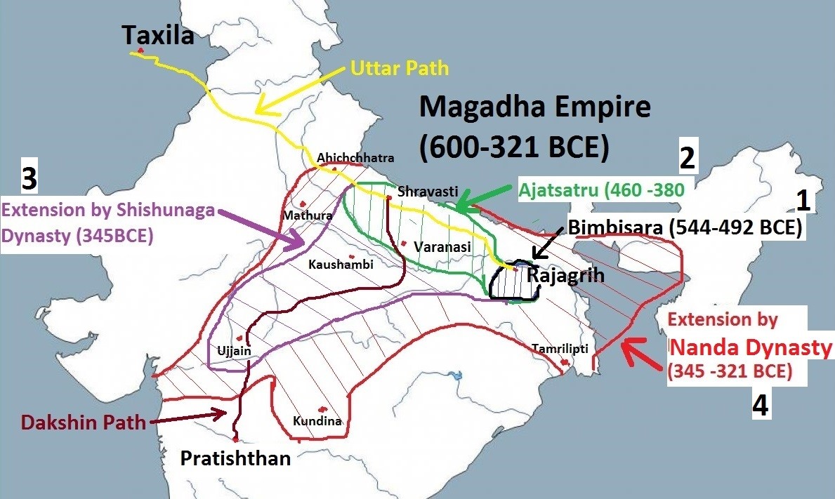
- (a) Magadha: Covered modern Patna and Gaya districts, guarded by its initial natural capital at Rajgir before moving to Pataliputra.
- (b) Kosala: Occupied eastern Uttar Pradesh with its capital at Sravasti, including major urban centers like Ayodhya.
- (c) Anga: Located near Bhagalpur, its early capture provided Magadha with useful eastern river trade access.
- (d) Kasi: Centered at Varanasi, this state fell to neighboring Kosala before being absorbed by Magadha.
- (e) Vatsa: Stationed along key Yamuna river paths, governing trade from its base at Kausambi.
- (f) Avanti: Controlled central trade routes from its twin capitals at Ujjain and Mahishmati.
Expansion of the First Magadhan Empire: A Story of Dynastic Growth and Conquest
A succession of energetic dynasties transformed Magadha from a regional kingdom into the dominant power of northern India.
Haryanka, Shishunaga, and Nanda Dynasty Rulers
Targeted diplomatic marriages, strategic river fortresses, and professional standing armies fueled Magadha's steady rise.
- (i) Bimbisara (Haryanka Dynasty) annexed Anga and formed key matrimonial alliances with Kosala and Vaishali.
- (ii) Ajatasatru built fortresses near the Ganga, defeated the Lichchhavis, and secured control over Kasi.
- (iii) Udayin established the capital at Pataliputra, a strategic river junction commanding water transport across the region.
- (iv) The Sisunaga and Nanda dynasties expanded Magadha's borders further, building up vast treasuries and large forces that set the stage for the Mauryan Empire.
Magadha Triumph: Key Reasons for Regional Dominance and Success
Magadha's ultimate success stemmed from a combination of geographical features, innovative military tactics, and strong economic resources.
Geography, Military, and Economy as Drivers of Success
Five main factors enabled Magadha to outmatch its regional opponents over time.
- (i) Natural Defenses: Iron deposits provided weapon supplies, while hill and river barriers protected Rajgir and Pataliputra.
- (ii) Military Innovations: Magadhan forces deployed trained war elephants to break opposing infantry formations.
- (iii) Economic Strength: Rich agricultural lands yielded steady revenues to maintain full-time military forces.
- (iv) Pragmatic Diplomacy: Magadhan kings combined strategic royal marriages with direct military actions.
- (v) Flexible Society: A pragmatic cultural atmosphere made it easier to integrate diverse local populations during expansion.
Quick Revision Capsule
Key political, geographical, and economic features of the major regional powers:
| Mahajanapada | Capital City | Core Significance |
|---|---|---|
| Magadha | Rajgir / Pataliputra | Rich iron deposits, river defense, and early military expansion. |
| Kosala | Sravasti | Major Gangetic power; included Ayodhya and Sakya territories. |
| Avanti | Ujjain / Mahishmati | Central trade hub; key rival to Magadha's western expansion. |
| Vajji | Vaishali | Powerful Gana-Sangha confederacy governed by clan assemblies. |
| Gandhara | Taxila | Northwestern trade center connecting Indian and international routes. |
Summary
The 6th century BCE transition from small tribal Janapadas to centralized Mahajanapadas marked a key turning point in early Indian history. Driven by iron technology, higher agricultural yields, and growing river trade, these states built fortified capitals and maintained standing armies. While Gana-Sanghas offered a collective republican alternative, centralized monarchies proved more effective at military expansion. Magadha used its natural iron deposits, river fortifications, agricultural base, and war elephants to defeat its rivals—setting the stage for the Maurya Empire and India's Second Urbanization.
Quick Revision Points
Essential takeaways for rapid review:
- (i) Anguttara Nikaya provides the foundational list of the 16 Mahajanapadas.
- (ii) Iron tools and paddy transplantation generated the farm surpluses that funded state administration.
- (iii) Monarchies levied a standard 1/6th grain tax (Bhaga) on harvests.
- (iv) Magadha secured control by moving its capital to the river junction at Pataliputra and deploying war elephants.
- Exam Tip: Pay close attention to the distinction between Gana-Sangha republics (like Vajji) and monarchies (like Magadha). Remember key rulers like Bimbisara, Ajatasatru, and Udayin, along with the strategic importance of Pataliputra's location.
Frequently Asked Questions (FAQ)
Q1: What distinguished a Janapada from a Mahajanapada?
A1: A Janapada was a smaller, clan-based settlement. A Mahajanapada was a larger, consolidated territorial state with a fortified capital, organized administration, and standing armed forces.Q2: How did iron technology encourage the growth of Mahajanapadas?
A2: Iron tools allowed farmers to clear dense forests and till heavy alluvial soils across the Gangetic plain. This increased agricultural yields, creating food surpluses that supported non-farming urban populations and military forces.Q3: Why was Pataliputra such a strategically important capital for Magadha?
A3: Located at the junction of major rivers like the Ganga and Son, Pataliputra served as a natural water fortress. It gave Magadha control over river trade, communication routes, and regional troop movements.