Geographical Features of India: Location, Boundaries, Coastline, and Unique Features
Geographical Location and Extent
Location:
India is located entirely in the northern hemisphere.
India is specifically located in the south-central part of the continent of Asia.
Latitudinal and Longitudinal Extent:
The mainland of India extends between latitudes 8°4’N and 37°6’N.
The mainland of India extends between longitudes 68°7’E and 97°25’E.
India’s locational extent is from 8° 4′ north to 37° 6′ north latitude.
India’s longitude ranges from 68° 7′ east to 97° 25′ east.
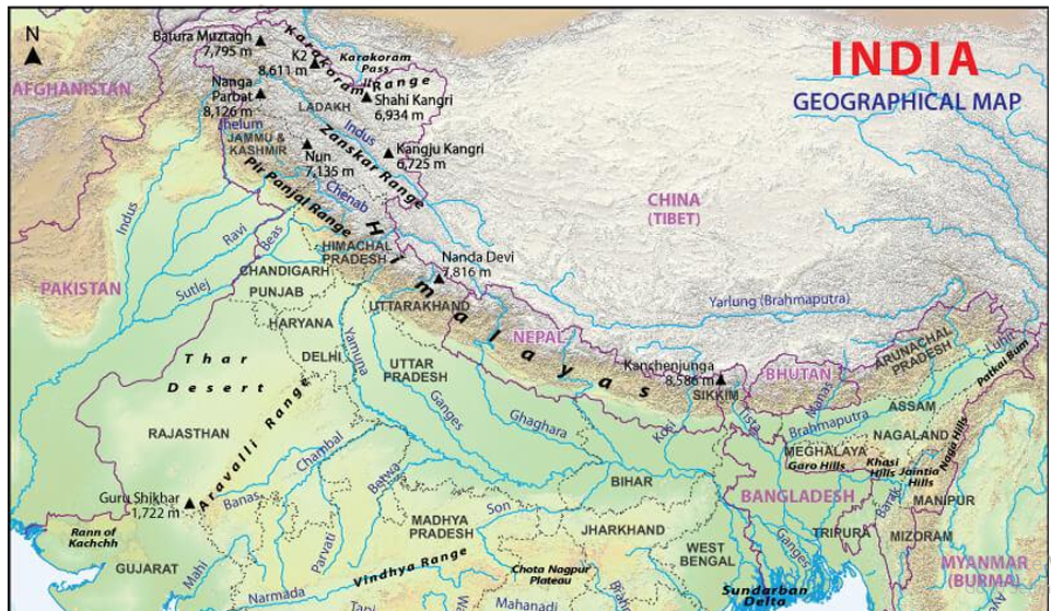
Geographical Features Map of India
Size and Area:
India is the 7th largest country in the world.
With an area of 32,87,263 sq km, India is the seventh-largest country in the world.
India accounts for about 2.4 percent of the total surface area of the world.
North-South and East-West Extent:
The latitudinal and longitudinal extent of the mainland is about 30°.
The north-south extent from Indira Col in Kashmir to Kanniyakumari is 3,214 km.
The east-west width from the Rann of Kachchh to Arunachal Pradesh is 2,933 km.
The east-west extent appears to be smaller than the north-south extent.
Boundaries and Coastline
Land Boundaries:
India has a land boundary of about 15,200 km.
India is bounded by young fold mountains in the northwest, north, and northeast.
Geographical Features Map of India
Coastline:
The total length of the coastline of the mainland, including Andaman and Nicobar and Lakshadweep, is 7,516.6 km.
Distinct Geographical Features
Physical Features:
Tropic of Cancer passing through states in India
India is marked off by mountains and the sea, giving it a distinct geographical entity.
South of about 22° north latitude, India begins to taper and extends towards the Indian Ocean.
India is divided into two seas: the Arabian Sea on the west and the Bay of Bengal on the east.
South of 22° north latitude, the country tapers off over 800 km into the Indian Ocean as a peninsula.
The southernmost point of the country, Pygmalion Point or Indira Point, is located at 6° 45′ N latitude.
Tropic of Cancer passing through states in India
Tropic of Cancer:
Tropic of Cancer passing through states in India
The Tropic of Cancer passes through the middle of the country, dividing it into two latitudinal halves.
The Tropic of Cancer passes through eight states in India: Gujarat (Jasdan), Rajasthan (Kalinjarh), Madhya Pradesh (Shajapur), Chhattisgarh (Sonhat), Jharkhand (Lohardaga), West Bengal (Krishnanagar), Tripura (Udaipur), and Mizoram (Champhai).
The area to the north of the Tropic of Cancer is nearly twice the area which lies to the south of it.
Time Zone and Standard Meridian
Time Lag:
From Gujarat to Arunachal Pradesh, there is a time lag of two hours.
Time along the Standard Meridian of India (82°30’E) passing through Mirzapur (in Uttar Pradesh) is taken as the standard time for the whole country.
Influence of Latitude:
The latitudinal extent influences the duration of day and night as one moves from south to north.
Coastline of India
India is a country that is surrounded by the sea on three of its sides. The coastal plains in India are along the west and east of the country. Extending up to 7516.6 km, the coastal plains in India are of two types:
Eastern Coastal Plains of India:
The eastern coastal plains stretch from West Bengal in the north to Tamil Nadu in the south and pass through Andhra Pradesh and Odisha.
Deltas of the rivers Mahanadi, Krishna, Godavari, and Cauveri are present in the eastern coastal plain. The deltas are very fertile and productive for agriculture. Therefore, the delta of the River Krishna is called the ‘Granary of South India‘.
Eastern Coastal plains of India
The Eastern coast is divided into three categories:
Utkal Coast: Extending between the Chilika Lake and Kolleru Lake, the Utkal Coast is much wider than the western coastal plains and undergoes immense rainfall. Some of the crops cultivated here are rice, coconut, and banana.
Andhra Coast: Extending between the Kolleru Lake and Pulicat Lake, the Andhra Coast forms a basin area for the Krishna and the Godavari rivers.
Coromandel Coast: The Coromandel Coast extends between Pulicat Lake and Kanyakumari in Tamil Nadu. This Indian coastline remains dry in summer and receives rainfall during the winter due to the north-east monsoons.
Chilka Lake and the Pulicat Lake (lagoon) are the important geographical features of the east coast.
Chilika and Pulicat lakes
Western Coastal Plains of India:
The Western Coastal Plains stretch from Kerala in the south to Gujarat in the north, passing through Karnataka, Goa, and Maharashtra. The western coastal plains stretch for 1500 km north to south and its width ranges from 10 to 25 km. The West Continental Shelf is at its widest off the Bombay coast, which is rich in oil.
Along the Malabar Coast, there are many beautiful lagoons that make the place a tourist destination. The western coast is narrower than the eastern coast.
Western Coastal plains of India
The western coast is further divided into four categories:
Kachchh and Kathiawar Coast: Kachchh, formerly a gulf, is formed by the deposition of silt by the Indus. The area of Kachchh is covered with shallow water during the monsoons and is divided into the Great Rann in the north and the Little Rann in the east. Kathiawar is situated to the south of Kachchh.
Konkan Coast: It extends between Daman in the north to Goa in the south. Rice and cashew are the two important crops of this region.
Kanada Coast: It extends between Marmagaon and Mangalore and is rich in iron deposits.
Malabar Coast: Extending between Mangalore to Kanyakumari, the Malabar Coast is relatively broad. This region also consists of lagoons running parallel to the coast in southern Kerala.
Konkan Coast = Maharashtra Coast and Goa Coast; Malabar Coast = Kerala and Karnataka Coast.
Standard Time (Time Zone)
Timezone in India
Every place on Earth is measured in terms of its distance east or west of the prime meridian (0 longitude) in Greenwich, London, United Kingdom. This is also the reference point for Coordinated Universal Time (UTC) with 1 hour per 15 degrees longitude.
For Example: At 150 degrees west (or 150 W) longitude, the time should be 150 degrees divided by 15 degrees = 10 hours behind UTC, or UTC-10.
In India, 82° 30' E has been taken as the reference for Indian Standard Time (IST), which means India is ahead of UTC by 5 hours and 30 minutes.
The Indian Standard Meridian passes through Uttar Pradesh, Madhya Pradesh, Chhattisgarh, Odisha, and Andhra Pradesh.
India: Tropical or Temperate Country?
The temperate part (north of Tropic of Cancer) is twice the area of the tropical part.
But India has always been treated as a tropical country for two different reasons – physical and cultural.
Physical Geographical Reasons:
The country is separated from the rest of Asia by the Himalayas.
Its climate is dominated by the tropical monsoons, and the temperate air masses are blocked by the Himalayas.
Entire area south of the Himalayas is essentially tropical from a climatic point of view: Although the night temperatures in winter at several places in North India may come down to the level of those prevailing in temperate lands, yet clear skies and intense insolation raise the day temperatures to a tropical level.
Cultural Geographical Reasons:
Settlements, diseases, agricultural, and primary economic activities are all tropical in nature.
We use cookies to improve your experience on our website. By continuing to browse, you agree to our use of cookies. Please review our
Privacy Policy and
Terms of Use for more information.
Stay focused & Stay away from distractions
At Studento, we make sure you always remain focused on your studies